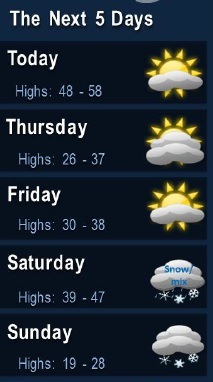
It may seem like spring in Wyandotte County today, but wait another day and winter will be back.
There will be a few chances for snow on the weekend, particularly on Sunday, according to the National Weather Service forecast.
Today, the high will be near 54 with increasing clouds and a north wind of 5 to 7 mph, the weather service said.
Tonight, the low will be 32 with mostly cloudy skies and a north northwest wind of 5 to 8 mph, according to the weather service.
Thursday, the temperature will reach only 33 degrees, with a north wind of 8 to 11 mph, the weather service said. It will start with mostly cloudy skies, then gradually become sunny.
Thursday night, the low will be around 14 with mostly clear skies, according to the weather service. A north northwest wind of 5 to 7 mph will become calm after midnight.
Friday, the high will be near 37 with mostly sunny skies, the weather service said. A calm wind will become south 5 to 8 mph in the morning.
Friday night, the low will be 29 with mostly cloudy skies, according to the weather service.
Saturday, The high will be near 44 with mostly cloudy skies, the weather service said.
Saturday night, the low will be around 16 with mostly cloudy skies, according to the weather service.
Sunday, there is a high near 23 with a chance of snow showers after noon, the weather service said. The chance of precipitation is 30 percent.
Sunday night, the low will be around 14 with partly cloudy skies, according to the weather service.
Monday, the high will be near 38 with partly sunny skies, the weather service said.
Monday night, the low will be around 23 with mostly cloudy skies, according to the weather service.
Tuesday, the high will be near 35 with mostly cloudy skies, the weather service said.