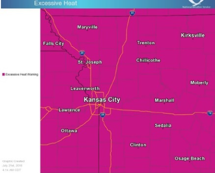
The excessive heat warning continues today through 8 p.m. July 24, according to the National Weather Service.
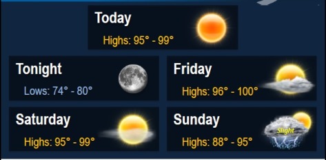
Temperatures into the first half of the weekend will soar well into the 90s area-wide, dropping off a few degrees on Sunday for the northern part of the region, the weather service said.
There is a slight possibility of thunderstorms on Friday afternoon in the northern part of the region and across the forecast area on Sunday as a frontal boundary approaches, according to the weather service.
The weather service advised residents to take extra precautions if they work or spend time outside. When possible, reschedule strenuous activities to early morning or evening. Wear light-fitting and loose-fitting clothing, drink plenty of fluids, stay in an air-conditioned room and out of the sun, and check on relatives and neighbors.
Never leave young children and pets alone in a vehicle as temperatures may reach lethal levels in minutes, the weather service said.
Today, expect a high of 98 with a heat index as high as 109, according to the weather service. A south southwest wind of 7 to 15 mph will gust as high as 22 mph.
Tonight, the low will be around 78 with a south wind of 8 to 13 mph, the weather service said.
Friday, the high will be near 99, with a heat index as high as 109, according to the weather service. A south southwest wind of 8 to 10 mph is possible.
Friday night, it will be mostly clear, with a low around 79, and a south wind of 8 to 10 mph, the weather service said.
Saturday, the high will be near 98, with a south southwest wind of 7 to 16 mph, gusting as high as 24 mph, according to the weather service.
Saturday night, the low will be 78.