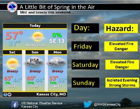
Today it will be sunny with a high near 58 and an elevated fire danger, according to the National Weather Service.
There will be sunny skies and a south southeast wind of 7 to 17 mph today, gusting as high as 25 mph, the weather service said.
With an elevated fire danger, dry conditions and wind, outdoor burning is discouraged today and Saturday, according to the weather service. Also, there is a chance of isolated strong storms Sunday evening over eastern Kansas.
Tonight, it will be mostly clear, with a low of 37, according to the weather service, and a southeast wind of 6 to 8 mph.
Saturday, the high will be near 61 with mostly sunny skies, the weather service said. A south wind of 9 to 15 mph will gust as high as 22 mph.
Saturday night, the low will be around 44 with partly cloudy skies and a south southeast wind around 11 mph, according to the weather service.
Sunday, there is a 20 percent chance of showers, with a high near 60, the weather service said. A south southeast wind of 11 to 15 mph will gust as high as 21 mph.
Sunday night, there is a 70 percent chance of showers and possibly a thunderstorm, with a low of 45, according to the weather service. New rainfall amounts may be between a tenth and a quarter inch.
Monday, expect a 30 percent chance of showers before noon, with a high near 54, the weather service said.
Monday night, the low will be around 31 with partly cloudy skies, according to the weather service.
Tuesday, the high will be near 44 with mostly sunny skies, the weather service said.
Tuesday night, the low will be around 27 with partly cloudy skies, according to the weather service.
Wednesday, the high will be near 44 with mostly sunny skies, the weather service said.