Friday morning, around sunrise, a brief window of wintry mix is possible across portions of southeastern Kansas into western Missouri, according to the National Weather Service.
During the morning commute, slick spots are possible on secondary roads, bridges and overpasses, the weather service said.
Friday, temperatures will rise, and rain will be the primary precipitation type during the day, according to the weather service. Around sunset, a transition to a rain-snow mix will occur, according to the weather service.
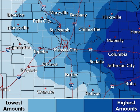
Friday night to Saturday morning, precipitation chances will increase and snow will become the primary precipitation type, the weather service said. Minor accumulations are possible.
On Saturday, precipitation chances continue, as snow will transition into a mix of rain, drizzle and snow in the afternoon as temperatures rise above freezing, according to the weather service.
From Saturday night to early Sunday, lingering light snow will remain possible, ending through sunrise Sunday, the weather service said.
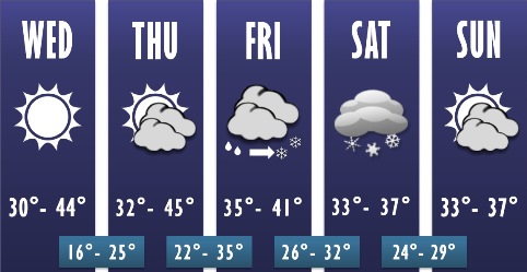
Today, there is no precipitation in the forecast. It will be sunny with a high near 40 and a north northwest wind of 7 to 13 mph, the weather service said.
Tonight, it will be partly cloudy with a low around 23 and a north northwest wind of 5 mph becoming calm, according to the weather service.
Thursday, it will be mostly sunny with a high near 42 and an east southeast wind of 5 to 10 mph, the weather service said.
Thursday night, there will be increasing clouds, with a low of 33 and a south southeast wind of 6 to 9 mph, according to the weather service.
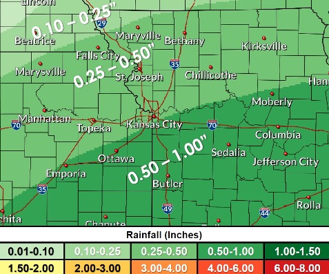
Friday, rain is likely, mainly after noon, with a high near 40 and a south southeast wind of 7 mph, the weather service said. The chance of precipitation is 80 percent. Between a tenth and quarter-inch of precipitation is possible.
Friday night, there is a 90 percent chance of rain before 7 p.m., then rain and snow between 7 p.m. and 9 p.m., then snow after 9 p.m., according to the weather service. The low will be around 30. New precipitation amounts will be between a tenth and quarter-inch of rain.
Saturday, there is a 60 percent chance of snow before 11 a.m., then rain and snow are likely between 11 a.m. and noon, then a chance of drizzle and snow after noon, the weather service said. The high will be near 36.
Saturday night, there is a 40 percent chance of snow before midnight, with a low of 28, according to the weather service.
Sunday, it will be mostly cloudy with a high of 36, the weather service said.
Sunday night, it will be partly cloudy with a low of 26, according to the weather service.
Monday, it will be mostly sunny with a high near 42, the weather service said.
Monday night, it will be mostly clear, with a low of 29, according to the weather service.
Tuesday, it will be mostly sunny with a high near 48, the weather service said.