
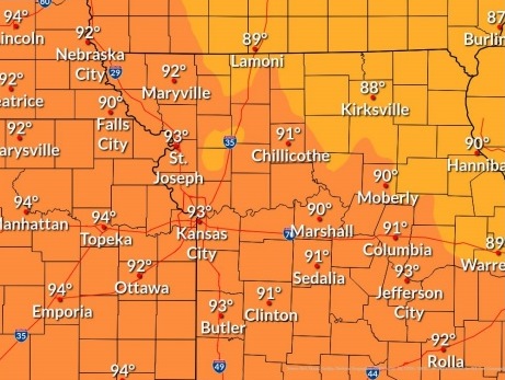
Today’s high may reach 94, according to the National Weather Service forecast.
An orange ozone air quality alert has been issued by the Mid-America Regional Council for the Greater Kansas City area today.
People and businesses are urged to avoid activities that lead to ozone formation, according to the alert. These activities include refueling, vehicles or topping off when refueling, idling vehicles unnecessarily and using gasoline-powered lawn equipment. Positive activities include car pooling, biking to work, delaying or combining errands, and using water-based paints and cleaners.
When pollution levels are elevated, the Mid-America Regional Council recommends that individuals consider limiting strenuous outdoor physical activity to reduce the risk of adverse health effects.
People who may be especially sensitive to the effects of elevated levels of pollutants include the very young, and those with pre-existing respiratory problems such as asthma or heart disease. Those with symptoms should consider consulting their personal physician.
Low humidity today may keep the heat index around the air temperature, the weather service said.
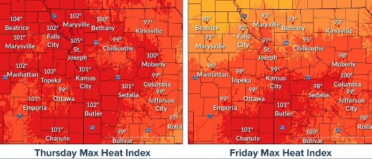
On Thursday, increasing humidity will lead to a heat index in the upper 90s to lower 100s in the afternoon, according to the weather service.
Thunderstorms are possible on Friday afternoon and evening, and through the weekend, the weather service said. A few storms could be strong to severe Friday. The highs will decline into the 80s next week.
Today, there is a 20 percent chance of showers and thunderstorms before 10 a.m., the weather service said. It will be sunny with a high near 94 and a heat index as high as 98. A south southeast wind will be 3 to 6 mph.
Tonight, there will be increasing clouds, with a low of 73 and a south wind of 6 mph, according to the weather service.
Thursday, there is a 10 percent chance of showers and thunderstorms before 1 p.m., the weather service said. The high will be near 99 with a heat index as high as 103. A south southwest wind will be 7 to 13 mph, gusting as high as 20 mph.
Thursday night, it will be mostly clear, with a low of 78, according to the weather service. A south southwest wind will be around 10 mph, gusting as high as 20 mph.
Friday, there is a 20 percent chance of showers and thunderstorms after 1 p.m., with a high near 98. A southwest wind will be 6 to 9 mph, gusting as high as 20 mph.
Friday night, there is a 40 percent chance of showers and thunderstorms, with a low of 70, according to the weather service. Less than a tenth of an inch of rain is expected.
Saturday, it will be mostly sunny, with a high near 91, the weather service said.
Saturday night, there is a 30 percent chance of showers after 1 a.m., with a low of 72, according to the weather service.
Sunday, there is a 30 percent chance of showers, with a high near 92, the weather service said.
Sunday night, there is a 50 percent chance of showers and thunderstorms, with a low of 69, according to the weather service.
Monday, there is a 30 percent chance of showers, with a high near 83, the weather service said.