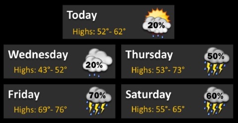
The temperature has dropped around 20 degrees today as a cold front moved into the area, the National Weather Service reported.
There will be showers to the south and north of the Kansas City area today, but as of this morning, no rain is predicted for Wyandotte County today, according to the weather service.
The chance of thunderstorms returns Thursday through Friday in the area, and the potential for severe weather is low.
Skies will be partly sunny today with a high near 61, the weather service said. A northeast wind will be 7 to 15 mph, gusting as high as 23 mph.
Tonight, the low will be around 36, with a northeast wind of 10 to 14 mph, gusting as high as 20 mph, according to the weather service.
Wednesday, there will be a 20 percent chance of showers before 1 p.m., the weather service said. The high will be near 51, with an east wind of 10 to 13 mph, gusting as high as 18 mph.
Wednesday night, there is a 40 percent chance of showers after 1 a.m., with a low of 41, according to the weather service. An east southeast wind of around 11 mph is predicted.
Thursday, expect a 40 percent chance of showers before 1 p.m., with a high near 69, according to the weather service. A southeast wind of 10 to 15 mph will gust as high as 25 mph.
Thursday night’s forecast is mostly cloudy with a low of 58, the weather service said.
Friday, there is an 80 percent chance of showers and thunderstorms after 1 p.m., according to the weather service. The high will be near 70.
Friday night, there is a 40 percent chance of showers, with a low around 48, the weather service said.
Saturday, there will be a 40 percent chance of rain, with a high near 63, according to the weather service.