Weather starts to warm up with high of 23 today

National Weather Service graphic
Snow was still on the ground on Thursday morning in Wyandotte County, where the temperature was 9 degrees at 9 a.m. Today, temperatures may rise to a high of 23.

The weather is starting to warm up, although cold temperature will continue on Thursday, with lows in the single digits in the morning, according to the National Weather Service forecast.

It was 9 degrees at 9 a.m. Thursday, according to the weather service.

Lows tonight will drop into the teens for one more night before teens and 20s expected through the weekend, the weather service said.

Highs will rebound slowly, with highs in the lower 30s for many on Friday and finally above freezing for most on Saturday, according to the weather service.

The wind chill will be between minus 1 and 9 Thursday and between minus 4 and 6 on Friday, the weather service said. Tonight, the wind chill will be between minus 4 and 1.

To see a list of warming centers, visit https://wyandotteonline.com/additional-warming-centers-open-in-kck/.

Friday will see a high of 33, while Saturday’s high will be near 38, according to the weather service.

There is a 30 percent chance of light snow and rain on Sunday, the weather service said. Expect mixed precipitation in the morning and continuing through the day. Temperatures will rise to about 40 degrees Sunday afternoon.

By Tuesday, the high will reach 55, according to the weather service.

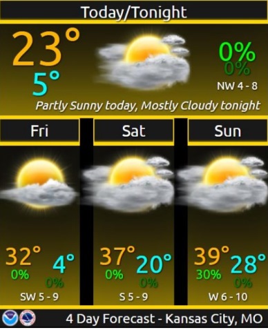
Today, it will be partly sunny, with a high near 23 and wind chill values between minus 1 and 9, the weather service said. A calm wind will become west northwest 5 to 7 mph in the afternoon.

Tonight, it will be partly cloudy, with a low of 3 and wind chill values between minus 4 and 1, according to the weather service. A west northwest wind around 5 mph will become calm.

Friday, it will be mostly sunny, with a high near 33 and wind chill values between minus 4 and 6. There will be a southwest wind of 5 to 9 mph.

Friday night, it will be mostly cloudy, with a low of 19, and a south wind of 7 mph, according to the weather service.

Saturday, it will be mostly sunny, with a high near 38 and a south wind of 6 to 8 mph, the weather service said.

Saturday night, it will be mostly cloudy, with a low of 27, according to the weather service.

Sunday, there is a 30 percent chance of snow, mixing with rain, after 11 a.m., then gradually ending. The high will be near 40.

Sunday night, it will be partly cloudy, with a low of 26, according to the weather service.

Monday, it will be sunny with a high near 49, the weather service said.

Monday night, it will be clear, with a low of 34, according to the weather.

Tuesday, it will be sunny, with a high near 55, the weather service said.

Tuesday night, it will be partly cloudy, with a low of 33, according to the weather service.

Wednesday, it will be mostly sunny, with a high near 51, the weather service said.

High near 22, chance of light snow today

National Weather Service graphic

Light snow is possible on Tuesday, mainly before 1 p.m., according to the National Weather Service.

The chance of snow also could continue in the afternoon, the weather service said.

Cold weather continues today, although warmer than Tuesday, with a high near 22, according to the weather service. Cold temperatures will continue through Friday morning. Saturday, the high will be near 37 and Sunday, the high will be 39. On Tuesday, the high will be 53.

The temperature was 8 degrees at 9 a.m. in Wyandotte County, with a wind chill of minus 2, according to the forecast.

Heavier snow today will be to the south of I-70, and only light amounts are forecast for the north, the weather service said.

A list of warming centers is at https://wyandotteonline.com/additional-warming-centers-open-in-kck/.

Today, Ash Wednesday, there is a 60 percent chance of snow, mainly before 1 p.m., then a chance of flurries after 2 p.m., the weather service said. The high will be near 22, with an east southeast wind around 6 mph. Total daytime snow accumulation for Wyandotte County will be less than a half-inch.

Tonight, it will be mostly cloudy, with a low of 5 and wind chill values between minus 2 and 3, according to the weather service. A northeast wind of 5 mph will become calm.

Thursday, it will be partly sunny, with a high near 22 and wind chill values between minus 2 and 8. There will be a north wind of 3 to 6 mph.

Thursday night, it will be partly cloudy, with a low of 2, according to the weather service. A northwest wind of 6 mph will become calm in the evening.

Friday, it will be mostly sunny, with a high near 31 and a light southeast wind becoming south southwest 5 to 9 mph in the morning, the weather service said.

Friday night, it will be mostly cloudy, with a low of 20, according to the weather service.

Saturday, it will be partly sunny, with a high near 37, the weather service said.

Saturday night, it will be mostly cloudy, with a low of 28, according to the weather service.

Sunday, it will be partly sunny, with a high near 39, the weather service said.

Sunday night, it will be partly cloudy, with a low of 25, according to the weather service.

Monday, it will be sunny, with a high near 48, the weather service said.

Monday night, it will be mostly clear, with a low of 33, according to the weather service.

Tuesday, it will be sunny, with a high near 53, the weather service said.

Dangerous cold continues today, snow in forecast

Today’s high will be about 10. The temperature at 10 a.m. was minus 4. (National Weather Service graphic)
Wyandotte County might get an inch or so of snow tonight and Wednesday. (National Weather Service graphic)

Dangerously cold temperatures continue today, according to the National Weather Service.

The temperature was minus 4 at 10 a.m., and today’s high will be near 10, the weather service said. The lowest temperature from last night to this morning was minus 8 at about 8 a.m. Tuesday.

Wind chill values Tuesday will be between minus 4 and 5, with an east southeast wind of 5 mph. The wind was calm at 10 a.m.

For a list of warming centers, visit https://wyandotteonline.com/additional-warming-centers-open-in-kck/.

Snow is in the forecast late tonight through Wednesday, the weather service said. Less than one inch of snow is in the forecast for tonight.

Areas to the south of Kansas City may receive 2 to 3 inches of snow.

A winter weather advisory is in effect from 9 p.m. Feb. 16 through 6 p.m. Feb. 17, according to the weather service.

Residents are advised to expect slippery road conditions tonight and Wednesday, that could affect commutes. They are asked to slow down and use caution while traveling.

The latest road conditions are available by calling 511, or by visiting the website, https://www.safetravelusa.com/. The kcscout.net website has highway conditions in the Greater Kansas City area.

Today, Mardi Gras, it will be mostly sunny and cold, with a high near 10, the weather service said. Wind chill values will be between minus 4 and 5. A calm wind will become east southeast around 5 mph in the afternoon.

Tonight, snow is likely, with a 60 percent chance of precipitation mainly after 3 a.m., according to the weather service. The low will be around 4 with wind chill values of between minus 3 and 2, and an east wind of 6 mph. New snow accumulation of less than one inch is in the forecast.

Wednesday, there is a 40 percent chance of snow, mainly before noon, the weather service said. There will be a high near 23 with wind chill values between minus 1 and 9. An east southeast wind will be 5 to 7 mph.

Wednesday night, it will be mostly cloudy, with a low of 7, according to the weather service. The wind chill will be between minus 1 and 4, with a northeast wind of 3 to 6 mph.

Thursday, it will be mostly sunny with a high near 23 and a north wind of 6 to 8 mph, the weather service said.

Thursday night, it will be mostly clear, with a low of 2, according to the weather service.

Friday, it will be mostly sunny, with a high near 32, the weather service said.

Friday night, it will be mostly cloudy, with a low of 19, according to the weather service.

Saturday, it will be partly sunny, with a high near 39, the weather service said.

Saturday night, it will be mostly cloudy, with a low of 31, according to the weather service.

Sunday, it will be partly sunny, with a high near 43, the weather service said.

Sunday night, it will be partly cloudy, with a low of 27, according to the weather service.

Monday, it will be sunny, with a high near 50, the weather service said.

For more weather information, visit www.weather.gov.