It’s as if winter doesn’t know it’s spring. Today, there is a 70 percent of rain and snow in Wyandotte County, the National Weather Service says.
But the forecast also says it will be less than an inch of snow accumulation.
Snow is predicted between 1 p.m. and 4 p.m. Monday.
Interestingly, today’s high will be above freezing at 37 degrees.
Temperatures were at 34 degrees at 9 a.m. Monday, and skies were mostly cloudy.
Winds Monday are predicted to be 5 to 7 mph, light and variable.
Tonight’s low will be 23 degrees.
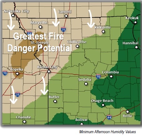
The National Weather Service said to look for an elevated fire danger on Wednesday, when winds may be 25 to 30 mph, and a chance of thunderstorms on Thursday.
Elevated fire danger on Wednesday (National Weather Service graphic)
High fire danger Saturday (National Weather Service graphic)
Hold off on any outdoor burning today, and hold off on planting anything that could be affected by a freeze.
The National Weather Service predicts a heightened fire danger this afternoon as humidity values fall in the region and wind speeds in the double digits are expected.
Today’s high may be 45 degrees, with winds currently at 12 mph. Temperature at 10 a.m. Saturday was 36 degrees, a wind chill of 28.
Sunday’s forecast is sunny and a high near 41.
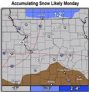
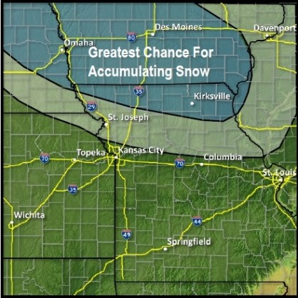
Then, on Monday, there will be a 40 per cent chance of snow and rain, with less than a tenth of an inch possible. The high will be near 43 Monday.
Chances for accumulating snow Monday (National Weather Service graphic)
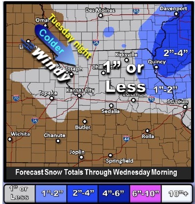
Possible snow totals through early Wednesday morning. (National Weather Service graphic)
Rain, snow, thunderstorms, wind, warm, cold – all of this is possible in the region during the next few days, according to the National Weather Service.
Enjoy today’s weather, because Wednesday’s will be 30 degrees colder.
Today started off with beautiful weather and temperatures of 54 degrees at 8 a.m.
The high is predicted to be 76 degrees this afternoon.
However, there is a slight, 10 percent chance of showers and thunderstorms after 5 p.m., the weather service said.
The threat of thunderstorms will develop late this afternoon and persist only into the early evening hours, the weather service said. The thunderstorms are most likely along a line from Butler to Chillicothe to Macon, Mo.
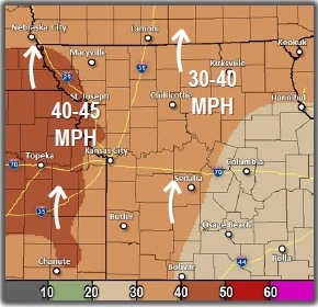
Tonight, rain is likely, possibly mixing with snow after 3 a.m., then gradually ending. Some thunder is also possible. The low will be around 31, and winds will blow from 17 to 22 mph, increasing to 25 to 30 mph in the evening. Winds may gust up to 39 mph.
Tonight’s chance of precipitation is 70 percent. New snow accumulation of less than half an inch is possible.
Wednesday, the weather will be mostly sunny, with a high near 44. Winds will be around 15 mph, with gusts as high as 22 mph.