Today’s weather: Red flag warning, windy, stormy, sunny and 76

Red flag warning from noon to 7 p.m. Monday, March 31. (National Weather Service graphic)

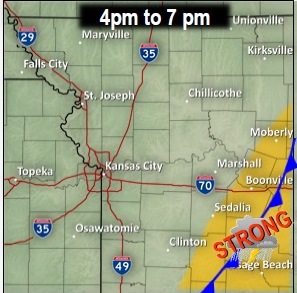
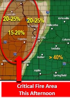
A red flag warning is in effect today from noon until 7 p.m.

A storm accompanied by lightning and rain that moved through around 6 a.m. Monday, March 31, will be  followed by windy and mostly sunny weather, with an afternoon high near 76.

Temperatures were 63 at 8 a.m.

There is a slight chance for another thunderstorm in the late afternoon.

Wind advisory in effect from 10 a.m. to 7 p.m. Monday, March 31. (National Weather Service graphic)

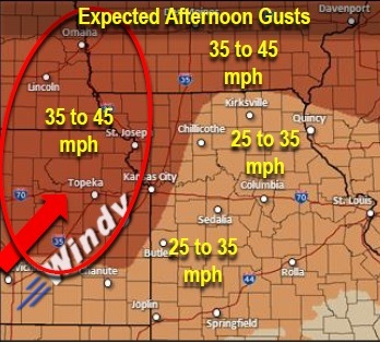
A wind advisory is in effect from 10 a.m. until 7 p.m. Monday.

The red flag warning means that there is a very high fire danger today. Residents are asked to avoid outdoor burning.

A cold front will move through the area, with temperatures at 35 degrees Monday night.

Tuesday’s high will be 54 degrees, and Wednesday, 57.

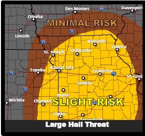
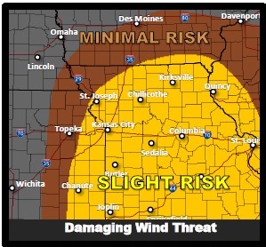
On Wednesday, strong to severe thunderstorms are possible in the region. inch of rain possible.

The chance of rain and storms continues on Thursday.

Mild weather in today’s forecast

Friday should be a day without rain or storms, according to the National Weather Service forecast.

Temperatures are expected to reach a high of 51 today, and skies will be partly sunny. A north wind will be around 6 mph.

Tonight’s low will be around 34.

Saturday, look for temperatures of 60 and sunny skies.

Sunday, temperatures rise to 73. Sunny skies and south winds of 13 to 18 mph, increasing to 19 to 24 mph, are in the forecast. Wind gusts could reach 32 mph on Sunday.

Sunday night brings a chance of showers after 1 a.m.

Monday’s forecast is mostly sunny, with a high near 68.

For those who are interested in planting a garden, take note: temperatures could reach a low of 32 degrees on Monday night.


Severe thunderstorms possible today


Large hail threat (National Weather Service graphic)
Damaging wind threat (National Weather Service graphic)
Tornado threat (National Weather Service graphic)


Strong to severe thunderstorms are expected to develop along a cold front this afternoon in the region.

According to the National Weather Service, the storms will begin just west of I-=35 and grow more organized as they push east of the Kansas City area.

Large hail and damaging winds are the primary threats of the storm, the weather service said.

If clouds clear out more than expected, the atmosphere will become unstable and the severe threat may be higher.

Timing of the storm may change, but the latest data suggests that storms will develop earlier in the afternoon in the Kansas City area.

A strong front will race through the area and move into central Missouri by the evening hours.

There is a slight risk of large hail, a slight risk of damaging winds and a minimal risk of tornadoes with this storm.

The chance of thunderstorms today is 30 percent in Wyandotte County.

Temperatures at 8 a.m. Thursday were 55 degrees. The temperature may rise to 67.

Winds today will be 22 mph to 28 mph, with gusts as high as 39 mph.

Timeline of storm: 11 a.m. to 3 p.m. (National Weather Service graphic)
Timeline of storm: 1 p.m. to 5 p.m. (National Weather Service graphic)


Timeline of storm: 4 p.m. to 7 p.m. (National Weather Service graphic)