Forecast: Today’s high near 92

Temperatures may reach a high in the low 90s on Monday. (National Weather Service graphic)

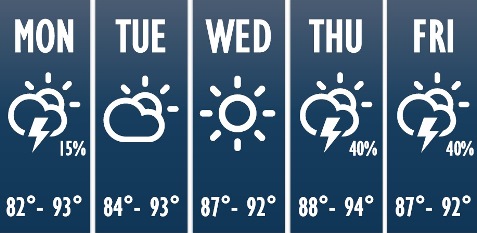
Temperatures could reach a high of 92 degrees today, according to the National Weather Service.

While there a a slight chance for a few storms to develop this afternoon, most areas will stay dry, the weather service said.

Storm chances will increase at the end of the week, with the greatest chances north of the Missouri River, according to the weather service.

Temperatures will gradually warm through the week, but humidity should be low enough to keep heat index concerns low, the weather service said.

Today, it will be sunny with a high near 92 and a south wind of 6 to 10 mph, the weather service said.

Tonight, it will be mostly clear, with a low of 71 and a south southeast wind of 6 to 8 mph, according to the weather service.

Tuesday, it will be sunny with a high near 91 and a south wind of 7 to 10 mph, the weather service said.

Tuesday night, it will be mostly clear, with a low of 70 and a south southeast wind of 7 mph, according to the weather service.

Wednesday, it will be sunny, with a high near 92 and a south wind of 6 to 10 mph, gusting as high as 20 mph, the weather service said.

Wednesday night, it will be mostly clear, with a low of 72, according to the weather service.

Thursday, it will be mostly sunny, with a high near 93, the weather service said.

Thursday night, there is a 40 percent chance of showers and thunderstorms after 1 a.m., with a low of 72, according to the weather service.

Friday, there is a 30 percent chance of showers and thunderstorms before 1 p.m., with a high near 92, the weather service said.

Friday night, there is a 40 percent chance of showers and thunderstorms, with a low of 72, according to the weather service.

Saturday, there is a 40 percent chance of showers and thundrstorms, with a high near 90, the weather service said.

Saturday night, there is a 50 percent chance of showers and thunderstorms, with a low of 68, according to the weather service.

Sunday, there is a 30 percent chance of showers and thunderstorms, with a high near 87, the weather service said.

Rain today, storms possible Tuesday

Rain is in the forecast today for Wyandotte County, and stronger storms are possible on Tuesday, according to the National Weather Service.

The storms Tuesday may be capable of small hail and gusty winds, the weather service said.

One to two inches of rain will be possible today through Wednesday, which could lead to minor river flooding, according to the weather service.

Today’s forecast calls for a 100 percent chance of rain, mainly before 3 p.m., the weather service said. The high will be near 63, with a light and variable wind becoming northwest 5 to 10 mph in the morning. Between a quarter and a half-inch of rain is possible.

Tonight, expect mostly cloudy skies with a low of 47, and a west northwest wind of 5 to 8 mph, according to the weather service.

Tuesday, There will be a 60 percent chance of showers, the weather service said. A thunderstorm is possible after 1 p.m. The high will be near 58 with a northwest wind of 5 to 9 mph becoming northeast in the afternoon. Between a tenth and a quarter inch of rain is likely.

Tuesday night, expect an 80 percent chance of rain and possibly a thunderstorm, according to the weather service. The low will be around 44 with a northeast wind of 10 to 16 mph, gusting as high as 28 mph. Between three-quarters and one inch of rain is possible.

Wednesday, there is a 60 percent chance of rain, mainly before 1 p.m., the weather service said. The high will be near 55. The north northwest wind will be 17 to 20 mph, gusting as high as 28 mph. Between a quarter and half-inch of rain is possible.

Wednesday night, there is a 20 percent chance of showers before 1 a.m., according to the weather service. The low will be around 39.

Thursday, skies will be sunny with a high near 56, the weather service said.

Thursday night, the low will be around 36 with mostly clear skies, according to the weather service.

Friday, expect sunny skies with a high near 61, the weather service said.

Friday night, skies will be mostly clear with a low of 46, according to the weather service.

Saturday, there will be sunny skies and a high near 71, the weather service said.

Beautiful day ahead; fire danger increases in afternoon

As temperatures today reach a high of 77 with mostly sunny skies, the National Weather Service is advising residents to be concerned about the potential for fire hazards as the dry weather continues.

Today, a north northeast wind will be 12 to 17 mph in the afternoon, the weather service said, gusting as high as 26 mph. A dry cold front is settling into the region.

With low relative humidity values, about 20 to 30 percent in the afternoon, and increasing wind speeds in the afternoon, there will be an elevated fire weather danger this afternoon, the weather service said.

If you still have vegetables outdoors in the garden, be alert on Friday night and Saturday, as the morning temperatures could dip down to near freezing in the region, creating the first frost of the season in some areas, according to the weather service.

Tonight, the low will be around 41, the weather service said. The north northwest wind will be 7 to 10 mph, according to the weather service.

Friday, the high will be near 61 with sunny skies and a north wind of 5 to 10 mph, the weather service said.

Friday night’s forecast is partly cloudy with a low of 39, according to the weather service. A north wind around 5 mph will become calm.

On Saturday, it will be partly sunny with a high near 58, and a southeast wind of 7 to 9 mph, the weather service said. Saturday night, expect partly cloudy skies with a low of 45.

Sunday’s forecast is mostly sunny and a high near 67, according to the weather service. Sunday night, it will be partly cloudy with a low of 53.