Today’s weather: Hot, windy with rain possible late tonight

The heat index could reach the mid-90s today. (National Weather Service graphic)
A south wind of 11 to 15 mph, gusting to 25 mph, is in today’s forecast. (National Weather Service graphic)
A 30 percent chance of rain and thunderstorms is possible tonight. (National Weather Service graphic)

Today’s forecast is hot and humid, according to the National Weather Service.

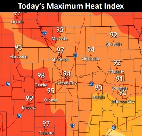
The heat index could reach into the mid-90s today, according to the weather service. The high temperature could be 87.

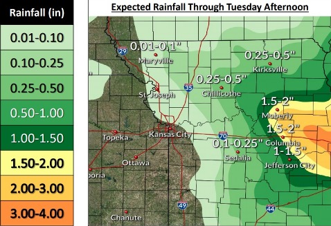
Scattered storms are possible overnight, with heavy rain in some areas, the weather service said.

Hot and humid conditions also are expected Tuesday through Thursday, according to the weather service.

The maximum heat index values could reach 105-110 degrees on Wednesday, the weather service said.

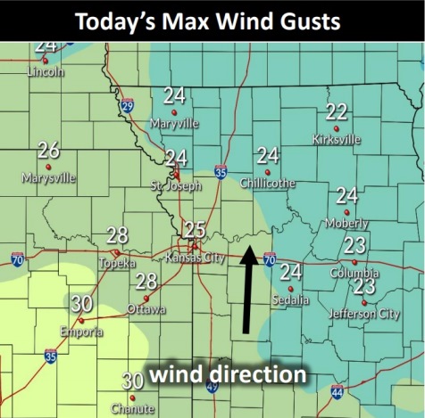
Today, it will be mostly cloudy, with a high near 87 and a south wind of 11 to 15 mph, gusting as high as 25 mph, the weather service said.

Tonight, there is a 30 percent chance of showers and thunderstorms, mainly between 1 a.m. and 4 a.m., according to the weather service. The low will be around 76 with a south southeast wind of 8 to 11 mph, gusting as high as 21 mph.

Tuesday, it will be partly sunny, with a high near 91 and a heat index as high as 102, the weather service said. A south wind will be 9 to 14 mph, gusting as high as 21 mph.

Tuesday night, there is a 20 percent chance of showers and thunderstorms after 1 a.m., according to the weather service. The low will be around 77 with a south wind of 7 mph.

Wednesday, it will be mostly sunny, with a high near 96, the weather service said, and a south wind around 6 mph.

Wednesday night, there is a 20 percent chance of showers and thunderstorms, with a low around 72, according to the weather service.

Thursday, it will be sunny, with a high near 94, the weather service said.

Thursday night, it will be partly cloudy, with a low of 72, according to the weather service.

Friday, it will be mostly sunny, with a high near 90, the weather service said.

Friday night, it will be partly cloudy, with a low of 71, according to the weather service.

Saturday, Independence Day, it will be mostly sunny, with a high near 91, the weather service said.

Saturday night, it will be mostly clear, with a low around 71, according to the weather service.

Sunday, it will be mostly sunny, with a high near 92, the weather service said.

Above normal temperatures and below normal precipitation are forecast for July 6 to July 12. (National Weather Service graphic)

Heat index could reach 97 today; showers, thunderstorms possible later

After 5 p.m. Friday and overnight, there is a slight risk of severe storms in Wyandotte County. Risks include flash flooding, damaging winds and hail. (National Weather Service graphic)

After a hot day, with temperatures in the 90s and a heat index that could reach 97, there will be a slight chance of showers and thunderstorms after 5 p.m. tonight, with more storms possible overnight and Saturday, according to the National Weather Service forecast.

Severe thunderstorms are possible this evening into the early morning hours Saturday, the weather service said.

The chance for severe storms will be greater to areas north of I-70, according to the weather service.

Large hail, damaging winds and heavy rain that could cause minor flooding are the primary hazards, the weather service said.

Off-and-on thunderstorm chances will persist through the weekend, when the threat of severe weather will be low, according to the weather service.

Today, it will be sunny with a high near 93, and the heat index could rise as high as 97, the weather service said. There will be a 10 percent chance of storms and showers after 5 p.m. A south southwest wind will be from 9 to 14 mph, gusting as high as 24 mph.

Tonight, there is a 70 percent chance of showers and thunderstorms, mainly after 1 a.m., according to the weather service. The low will be around 72 with a southwest wind of 9 to 13 mph, gusting as high as 20 mph. New rainfall amounts will be between a quarter and half-inch.

Saturday, there is a 60 percent chance of showers and thunderstorms, mainly after 1 p.m., the weather service said. The high will be near 86 with a south southwest wind of 8 to 11 mph. Between a tenth and quarter-inch of rain is possible.

Saturday night, there is a 50 percent chance of showers and thunderstorms, with a low of 73, according to the weather service. A calm wind will become south around 6 mph after midnight. Between a half and three-quarters of an inch of rain is possible.

Sunday, there will be a 20 percent chance of showers and thunderstorms, with a high near 92, the weather service said. The high will be near 92 with a south wind of 6 to 10 mph, gusting as high as 24 mph.

Sunday night, it will be mostly cloudy, with a low of 74, according to the weather service.

Monday, there is a 30 percent chance of showers and thunderstorms after 1 p.m., with a high near 91, the weather service said.

Monday night, there is a 30 percent chance of showers and thunderstorms after 1 a.m., with a low of 73, according to the weather service.

Tuesday, there is a 40 percent chance of showers and thunderstorms, with a high near 92, the weather service said.

Tuesday night, there is a 30 percent chance of showers and thunderstorms, with a low of 72, according to the weather service.

Wednesday, there is a 30 percent chance of showers and thunderstorms, with a high near 92, the weather service said.

Wednesday night, there is a 30 percent chance of showers and thunderstorms, with a low of 70, according to the weather service.

Thursday, there is a 40 percent chance of showers and thunderstorms, with a high near 90, the weather service said.

Thursday’s weather: Warmer, chance of rain

On Friday, Wyandotte County will be in a marginal risk area for severe storms. (National Weather Service graphic)

Thursday’s temperatures could reach a high of 91, according to the National Weather Service, with a slight chance of rain.

Scattered showers and thunderstorms may linger across portions of the region today, the weather service said.

Early Friday, there could be more scattered showers and isolated thunderstorms across portions of the region, according to the weather service.

Severe thunderstorms are possible Friday afternoon into the evening, most likely for areas north of I-70, the weather service said. Large hail, damaging winds and heavy rains could result in minor flooding.

Off-and-on thunderstorm chances will persist through the weekend, according to the weather service. The threat of severe weather is low.

Today, there is a 20 percent chance of showers and thunderstorms before 10 a.m., the weather service said. It will be sunny, with a high near 91 and a south wind of 6 to 11 mph.

Tonight, it will be mostly clear, with a low of 72 and a south wind of 9 to 11 mph, gusting as high as 21 mph, according to the weather service.

Friday, there is a 30 percent chance of showers and thunderstorms after 1 p.m., with a high near 92, the weather service said. The heat index could be as high as 97. A south southwest wind of 10 to 17 mph will gust as high as 25 mph.

Friday night, there is an 80 percent chance of showers and possibly a thunderstorm, with a low of 72, according to the weather service. A south southwest wind of 6 to 9 mph will gust as high as 20 mph. Between a half and three-quarters of an inch of rain is possible.

Saturday, there is a 50 percent chance of showers and thunderstorms, with a high near 87, the weather service said, and a south southwest wind of 6 mph. Between a quarter and half-inch of rain is possible.

Saturday night, there is a 40 percent chance of showers and thunderstorms, with a low of 73, according to the weather service. Between a half and three-quarters of an inch of rain is possible.

Sunday, there is a 30 percent chance of showers and thunderstorms, with a high near 91, the weather service said.

Sunday night, it will be partly cloudy, with a low of 76, according to the weather service.

Monday, there is a 30 percent chance of showers and thunderstorms after 1 p.m., with a high near 90, the weather service said.

Monday night, there is a 30 percent chance of showers and thunderstorms, with a low of 76, according to the weather service.

Tuesday, there is a 30 percent chance of showers and thunderstorms, with a high near 91, the weather service said.

Tuesday night, there is a 40 percent chance of showers and thunderstorms, with a low of 72, according to the weather service.

Wednesday, there is a 40 percent chance of showers and thunderstorms, with a high near 89, the weather service said.