Heat index could reach 98 today

The heat index could rise to the high 90s today in Wyandotte County. (National Weather Service graphic)
At left, there is a greater chance for strong to severe thunderstorms from 3 a.m. to 9 a.m. Thursday, according to the weather service, with heavy rain and high winds possible. The green area has a smaller chance for severe storms. Winds could be 30 to 50 mph. (National Weather Service graphic)

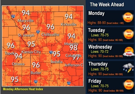
The heat index in Wyandotte County could reach 98 today, with a high near 92 in the National Weather Service forecast.

Heat indices will likely rise above 85 degrees by 9 a.m. and persist until at least 9 p.m., the weather service said. Winds will be out of the south between 10 to 15 mph, with occasional gusts going over 20 mph this afternoon.

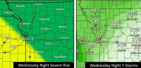
A round of strong to severe overnight storms will move into the area after 4 a.m. Thursday, possibly lasting until midday, according to the weather service. The storms could linger in the area through Friday.

Wyandotte County is on the edge of this system, with smaller chances for severe storms, the weather service said. Winds could gust to 30 to 50 mph in some areas.

Warm and humid conditions are expected for the upcoming weekend, along with another chance for storms on Saturday, according to the weather service.

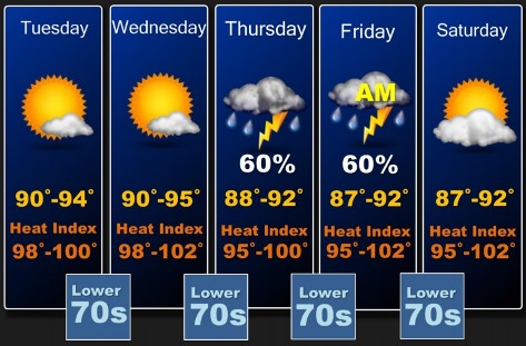
Today, it will be sunny with a high near 92 and a heat index as high as 98, the weather service said. A light south southwest wind will become south 5 to 9 mph in the morning.

Tonight, there is a 30 percent chance of showers and thunderstorms after 4 a.m., according to the weather service. The low will be around 74 with a south southeast wind of 5 to 8 mph. Less than a tenth of an inch of rain is possible.

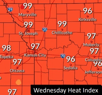
Thursday, there is a 50 percent chance of showers and thunderstorms, with a high near 89, and a southwest wind of 5 to 7 mph, the weather service said. The heat index will be as high as 96. Less than a tenth of an inch of rain is possible.

Thursday night, there is a 40 percent chance of showers and thunderstorms, with a low of 71, according to the weather service. A west northwest wind of 6 mph will become calm in the evening. Between a half and three-fourths of an inch of rain is possible.

Friday, there is a 20 percent chance of showers and thunderstorms before 1 p.m., according to the weather service. The high will be near 92 with a calm wind.

Friday night, there is a 20 percent chance of showers and thunderstorms after 1 a.m., with a low of 73, according to the weather service.

Saturday, there is a 30 percent chance of showers and thunderstorms after 1 p.m., with a high near 93, the weather service said.

Saturday night, there is a 30 percent chance of showers and thunderstorms before 1 a.m., with a low of 70, according to the weather service.

Sunday, it will be sunny with a high near 90, the weather service said.

Sunday night, it will be mostly clear, with a low of 69, according to the weather service.

Monday, it will be sunny, with a high near 91, the weather service said.

Monday night, it will be mostly clear, with a low of 74, according to the weather service.

Tuesday, it will be mostly sunny, with a high near 95, the weather service said.

For more weather information, visit www.weather.gov.

Heat index could reach 98 today

National Weather Service graphic

Temperatures today could top out at 93 with a heat index of 98, according to the National Weather Service forecast.

There is a very slight chance of showers this afternoon.

Hot and humid conditions will affect the area from Wednesday through the end of the week, the weather service said.

The heat index all week will be in the mid 90s to the lower 100s, according to the weather service.

The next chance for widespread storms will come Thursday or as early as Wednesday night, the weather service said.

Storms could be strong, but widespread severe weather is not yet anticipated, according to the weather service.

Today, it will be mostly sunny, with a high near 93 and a heat index as high as 98, the weather service said. A calm wind will become south around 6 mph in the afternoon.

Tonight, it will be mostly clear, with a low of 73 and a south southeast wind of 3 to7 mph, according to the weather service.

Wednesday, it will be sunny with a high near 94 and a heat index as high as 99, the weather service said. A light south wind will increase to 6 to 11 mph in the morning.

Wednesday night, it will be mostly clear, with a low of 74 and a south southeast wind of 5 to 9 mph becoming calm in the evening, according to the weather service.

Thursday, there is a 50 percent chance of showers and thunderstorms, with a high near 92 and a south wind of 3 to 5 mph, the weather service said. Between a quarter and half-inch of rain is possible.

Thursday night, there is a 60 percent chance of showers and thunderstorms, mainly after 1 a.m., according to the weather service. The low will be around 72. Between a tenth and quarter-inch of rain is possible.

Friday, there is a 30 percent chance of showers and thunderstorms before 1 p.m., with a high near 91, the weather service said.

Friday night, it will be mostly clear, with a low of 71, according to the weather service.

Saturday, it will be mostly sunny, with a high near 92, the weather service said.

Saturday night, there is a 30 percent chance of storms and showers, with a low of 71, according to the weather service.

Sunday, it will be sunny with a high near 90, the weather service said.

Sunday night, it will be mostly clear, with a low of 70, according to the weather service.

Monday, it will be mostly sunny, with a high near 92, the weather service said.

Hot, humid weather ahead

National Weather Service graphic
Hot and humid weather is ahead, with the best chance for storms on Thursday of this week.

Hot and humid conditions will affect the area through the end of next week, according to the National Weather Service forecast.

Heat index values all week will be in the mid 90s to lower 100s, the weather service said.

The next chance for widespread thunderstorms will be Thursday, perhaps as early as Wednesday night, according to the weather service. Storms may be strong, but widespread severe weather is not anticipated as this time.

Today, it will be mostly sunny, with a high near 91 and a heat index as high as 95, the weather service said. A calm wind will become east southeast around 5 mph in the afternoon.

Tonight, it will be partly cloudy, with a low of 73 and an east southeast wind of 5 mph becoming calm in the evening, according to the weather service.

Tuesday, it will be mostly sunny, with a high near 92 and a heat index as high as 97, the weather service said. A calm wind will become southwest around 5 mph in the afternoon.

Tuesday night, it will be mostly clear, with a low of 73 and a south wind of 6 mph becoming calm in the evening, according to the weather service.

Wednesday, it will be sunny with a high near 92 and a calm wind becoming south 5 to 7 mph in the afternoon, the weather service said.

Wednesday night, there is a 20 percent chance of showers and thunderstorms after 2 a.m., according to the weather service. The low will be around 74.

Thursday, there is a 60 percent chance of showers and thunderstorms, after 8 a.m., the weather service said. The high will be near 90.

Thursday night, there is a 60 percent chance of showers and thunderstorms, mainly after 2 a.m., according to the weather service. The low will be around 72.

Friday, there is a 60 percent chance of showers and thunderstorms, mainly before 8 a.m., the weather service said. The high will be near 91.

Friday night, the low will be around 71, according to the weather service.

Saturday, it will be sunny with a high near 94, the weather service said.

Saturday night, it will be mostly clear, with a low of 73, according to the weather service.

Sunday, it will be mostly sunny, with a high near 90, the weather service said.