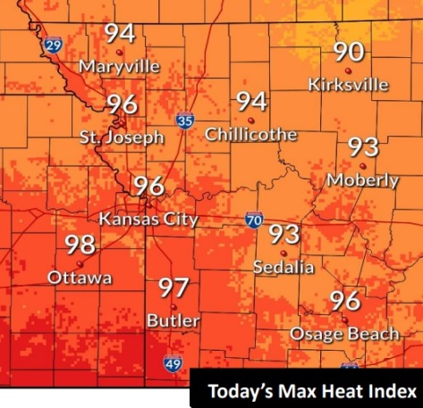
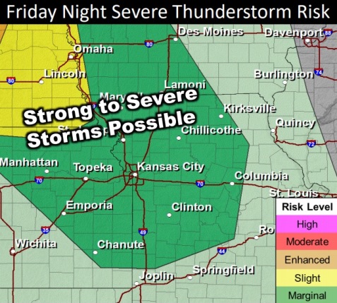
Temperatures today could reach 91, with a maximum heat index of 96. (National Weather Service graphic)Storms may move into the area on Friday night and Saturday morning. (National Weather Service graphic)
Temperatures today in Wyandotte County could reach a high of 91, with a heat index as high as 96, according to the National Weather Service.
The heat index may rise several degrees on Saturday, but it will depend on Saturday morning’s storms, the weather service said.
Storms are possible overnight today into Saturday morning, according to the weather service. Strong to severe storms are possible with wind and hail the main concerns. Storms will develop over the Dakotas and Nebraska on Friday afternoon, working its way southeast into the Kansas City area by late tonight into Saturday morning.
Today, it will be sunny with a high near 91 and a calm wind becoming east southeast around 6 mph in the afternoon, the weather service said.
Tonight, there is a 50 percent chance of showers and thunderstorms after 10 p.m., with a low of 71, and a southeast wind of 5 to 7 mph, according to the weather service.
Saturday, there is a 40 percent chance of showers and thunderstorms, mainly before 1 p.m., with a high near 91, the weather service said. The heat index could be as high as 95. A south southeast wind of 6 to 8 mph will become northwest in the afternoon. Between a quarter and half-inch of rain is possible.
Saturday night, it will be mostly clear, with a low of 68 and a north northwest wind of 5 mph becoming calm in the evening, according to the weather service.
Sunday, it will be sunny with a high of 88 and a calm wind becoming north around 5 mph, the weather service said.
Sunday night, it will be mostly clear, with a low of 69, according to the weather service.
Monday, it will be sunny, with a high near 92, the weather service said.
Monday night, it will be partly cloudy, with a low of 74, according to the weather service.
Tuesday, it will be partly sunny, with a high near 95, the weather service said.
Tuesday night, it will be partly cloudy, with a low of 75, according to the weather service.
Wednesday, it will be partly sunny, with a high near 93, the weather service said.
Wednesday night, it will be partly cloudy, with a low of 75, according to the weather service.
Thursday it will be partly sunny, with a high of 96, the weather service said.
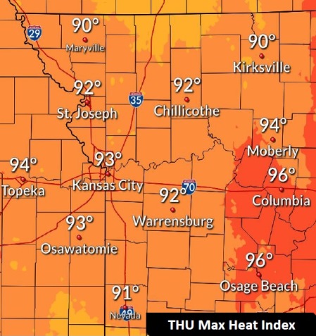
The high will be 88 today with a possible maximum heat index in the low 90s. (National Weather Service graphic)
After some rain this morning, the rest of the day could be dry for most people.
According to the National Weather Service, if another storm develops today, it could be strong to severe with wind and hail being the concerns.
Today’s high will be near 88, the weather service said. It was 74 degrees at 9 a.m.
The heat index will remain in the low to upper 90s for the rest of the week into the weekend, according to the weather service.
The next best chance for storms will be on Saturday morning, when strong to severe storms are possible, with wind and hail being the main concerns, the weather service said.
Today, there is a 30 percent chance of showers and thunderstorms, mostly before 10 a.m., the weather service said. The high will be near 88 with a light and variable wind becoming southwest 5 to 7 mph in the morning. Between a tenth and quarter-inch of rain is possible.
Tonight, there is a 20 percent chance of showers and thunderstorms, with a low of 70, according to the weather service. A west northwest wind of 5 mph will become calm in the evening.
Friday, the high will be near 92 with a heat index as high as 96, the weather service said. A calm wind will become north northeast around 5 mph in the afternoon.
Friday night, there is a 20 percent chance of showers and thunderstorms after 1 a.m., with a low of 73, according to the weather service.
Saturday, there is a 40 percent chance of showers and thunderstorms, with a high near 91, the weather service said. Between a quarter and half-inch of rain is possible.
Saturday night, there is a 20 percent chance of showers and thunderstorms before 1 a.m., with a low of 69, according to the weather service.
Sunday, it will be sunny with a high near 87, the weather service said.
Sunday night, it will be mostly clear, with a low of 67, according to the weather service.
Monday, it will be sunny, with a high near 91, the weather service said.
Monday night, it will be partly cloudy, with a low of 74, according to the weather service.
Tuesday, it will be mostly sunny, with a high near 95, the weather service said.
Tuesday night, it will be partly cloudy, with a low of 78, according to the weather service.
Wednesday, it will be mostly sunny and hot, with a high near 97, the weather service said.