Excessive heat warning issued for noon Friday in Wyandotte County

Wyandotte County will be under an excessive heat warning from noon Friday until 9 p.m. Sunday. (National Weather Service graphic)
On Friday, the heat index could be as high as 105 in Wyandotte County, according to the National Weather Service. (National Weather Service graphic)
On Saturday, the heat index could be as high as 106 in Wyandotte County, according to the National Weather Service. (National Weather Service graphic)
On Sunday, the heat index could reach as high as 102 in Wyandotte County, according to the National Weather Service. (National Weather Service graphic)

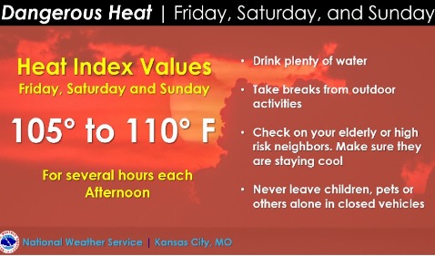
An excessive heat warning has been issued for noon Friday until 9 p.m. Sunday for Wyandotte County and the surrounding area, according to the National Weather Service.

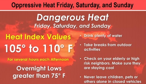
Dangerously hot conditions with heat index values between 105 and 110 degrees are expected each afternoon, the weather service said.

Saturday is expected to be the hottest day. Overnight lows will be above 75 degrees, providing very little relief, according to the weather service.

Residents should check on family members and elderly neighbors to make sure they are stay cool, the weather service said. Also, residents should drink plenty of fluids, stay in an air-conditioned room and stay out of the sun.

Those who work or spend time outside should reschedule strenuous activities to early morning or evening, according to the weather service. Wear lightweight and loose-fitting clothing when possible, take frequent rest breaks in the shade or in air-conditioning. Anyone overcome by the heat should be moved to a cool and shaded location. If there are symptoms of heat stroke, call 911.

There is a slight chance for a few storms on Friday afternoon and again on Sunday morning, the weather service said. No severe weather is expected.

Thunderstorm chances will increase Sunday night into early next week, according to the weather service.

Today, it will be mostly sunny with a high near 94 and a heat index as high as 105, the weather service said. A south wind will be 5 to 10 mph.

Tonight, it will be mostly clear, with a low of 78 and a south wind of 8 to 10 mph, according to the weather service.

Saturday, there is a 20 percent chance of showers and thunderstorms between 9 a.m. and 10 a.m., the weather service said. It will be sunny and hot, with a high near 97 and a heat index as high as 106. A south wind will be 10 to 17 mph, with gusts as high as 28 mph.

Saturday night, there is a 20 percent chance of showers and thunderstorms after 1 a.m., with a low of 76, according to the weather service. A south southwest wind of 8 to 13 mph may gust as high as 22 mph.

Sunday, there is a 20 percent chance of showers and thunderstorms, with a high near 94, the weather service said. A south southwest wind of 6 mph will become calm in the afternoon.

Sunday night, there is a 50 percent chance of showers and thunderstorms, with a low of 73, according to the weather service. Between a quarter and half-inch of rain is possible.

Monday, there is a 40 percent chance of showers and thunderstorms, with a high near 90, the weather service said.

Monday night, there is a 50 percent chance of showers and thunderstorms, with a low of 73, according to the weather service.

Tuesday, there is a 40 percent chance of showers and thunderstorms before 1 p.m., with a high near 89, the weather service said.

Tuesday night, there is a 30 percent chance of showers and thunderstorms after 1 a.m., with a low of 72, according to the weather service.

Wednesday, there is a 30 percent chance of showers and thunderstorms, with a high near 90, the weather service said.

Wednesday night, it will be partly cloudy, with a low of 74, according to the weather service.

Thursday, it will be partly sunny, with a high near 93,the weather service said.

Dangerous heat in forecast for Friday, Saturday and Sunday

National Weather Service graphic

Several days of dangerous high heat and humidity are expected Friday through the weekend, according to the National Weather Service.

The heat index may reach the lower 100s each day, with Saturday and Sunday being the hottest, the weather service said.

Residents should check on family members and elderly neighbors to make sure they are staying cool, the weather service said.

Thunderstorm chances will increase Sunday night into early next week, according to the weather service.

Today, the high will be near 88 with mostly sunny skies and a calm wind becoming east southeast around 6 mph in the afternoon, the weather service said.

Tonight, it will be partly cloudy, with a low of 73 and an east southeast wind of 6 mph, according to the weather service.

Friday, there is a 20 percent chance of showers and thunderstorms before 9 a.m., with a high near 94, the weather service said. The heat index will be as high as 102. A south southeast wind of 5 to 13 mph will gust as high as 18 mph.

Friday night, the low will be around 78 with a south wind of 8 mph, according to the weather service.

Saturday, it will be mostly sunny and hot, with a high near 97, the weather service said. A south southwest wind of 8 to 11 mph will gust as high as 25 mph.

Saturday night, it will be partly cloudy with a low of 78, according to the weather service.

Sunday, it will be mostly sunny, with a high near 96, the weather service said.

Sunday night, there is a 40 percent chance of showers and thunderstorms, with a high near 92, according to the weather service.

Monday, there is a 40 percent chance of showers and thunderstorms, with a high near 92, the weather service said.

Monday night, there is a 40 percent chance of showers and thunderstorms after 1 a.m., with a low of 72, according to the weather service.

Tuesday, there is a 30 percent chance of showers and thunderstorms, with a high near 89, the weather service said.

Tuesday night, it will be partly cloudy, with a low of 71, according to the weather service.

Wednesday, it will be mostly sunny, with a high near 90, the weather service said.

More rain, storms possible today

Wyandotte County is in an area of marginal risk for severe storms this afternoon and evening. (National Weather Service graphic)
There is a risk of hail and damaging winds in the region on Wednesday afternoon and evening. (National Weather Service graphic)
The area could get an inch of rain or more on Wednesday and Thursday. (National Weather Service graphic)

After a morning storm and rain, more rain is possible today, mainly before 2 p.m., according to the National Weather Service.

Heavy rain across the region could lead to local flooding and flash flooding this morning, the weather service said. Weather radar maps showed that storms now in the Topeka area could be headed toward Wyandotte County this morning.

There is a slight or 10 percent chance of severe storms later in the afternoon and evening, as well, according to the weather service. Hail, damaging winds and heavy rain are possible.

Today’s high will be in the low 80s, with temperatures expected to gradually increase through the end of the week. On Saturday, the high could be 97.

Today, showers and thunderstorms are possible before 2 p.m., the weather service said. The high will be near 82 with an east wind of 5 to 7 mph becoming north in the afternoon. Between a half and three-quarters of an inch of rain is possible.

Tonight, there is a 10 percent chance of showers and thunderstorms before 7 p.m., according to the weather service. The low will be around 70 with a north wind of 5 to 7 mph becoming calm in the evening.

Thursday, it will be partly sunny, with a high near 86 and a calm wind becoming east around 6 mph in the afternoon, the weather service said.

Thursday night, the low will be 72 with a calm wind, according to the weather service.

Friday, there is a 20 percent chance of showers and thunderstorms before 1 p.m., with a high near 94, the weather service said. A calm wind will become south 5 to 8 mph in the afternoon.

Friday night, it will be partly cloudy, with a low of 78, according to the weather service.

Saturday, it will be mostly sunny and hot, with a high near 97, the weather service said.

Saturday night, it will be mostly clear, with a low of 78, according to the weather service.

Sunday, it will be mostly sunny and hot, with a high near 97, the weather service said.

Sunday night, there is a 30 percent chance of showers and thunderstorms after 1 a.m., according to the weather service. The low will be around 76.

Monday, it will be mostly sunny, with a high near 95, the weather service said.

Monday night, there is a 30 percent chance of showers and thunderstorms, with a low of 75, according to the weather service.

Tuesday, it will be mostly sunny, with a high near 94, the weather service said.

For more weather information, visit www.weather.gov.