Severe storms possible, high fire danger today

Wyandotte County is under a wind advisory until 6 p.m. today. Winds could gust as high as 47 mph. (National Weather Service graphic)
Wyandotte County is under a slight risk for severe storms tonight. Rain and storms may move into the Wyandotte County area around 6 p.m. or 7 p.m. tonight. Quarter-size hail is possible in places. There also is a possibility of flash flooding through Thursday. (National Weather Service graphic)
The Wyandotte County area could receive more than 2 inches of rain tonight through Monday, with a possibility of flash flooding. (National Weather Service graphic)

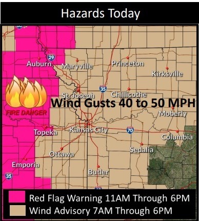
Wyandotte County is under a wind advisory from 7 a.m. to 6 p.m. Wednesday, and also, severe storms are possible tonight, according to the National Weather Service.

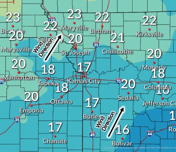
Very high fire weather danger is expected today, with dry conditions and south-southwest winds gusting as high as 47 mph, the weather service said. Use extra caution when driving, especially if operating a high-profile vehicle, and secure outdoor objects, the weather service advised.

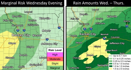
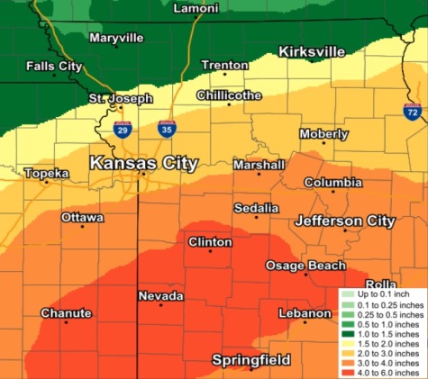
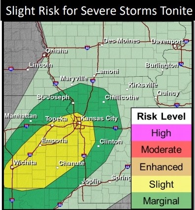
Thunderstorms are expected this evening into Thursday, according to the weather service. There is a 70 percent chance of precipitation tonight, and a few strong to isolated severe storms with quarter-sized hail are possible.

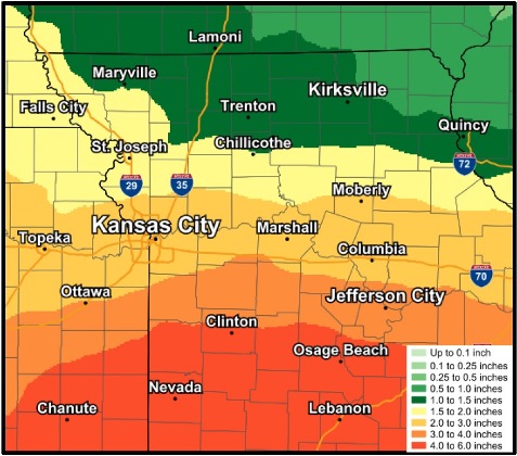
Additional rainfall will be possible through the weekend, the weather service said.

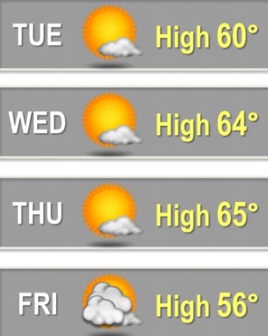
Today, it will be partly sunny, with a high near 74, the weather service said. It will be breezy, with a south southwest wind of 15 to 20 mph increasing to 24 to 29 mph in the afternoon. Winds may gust as high as 47 mph.

Tonight, there is a 70 percent chance of precipitation, with showers and thunderstorms possible, according to the weather service. Rain and storms may move into the area around 6 p.m. Showers are likely after midnight. The low will be around 42. It will be breezy, with a south southwest wind of 17 to 22 mph, becoming northwest 6 to 11 mph in the evening. Winds may gust as high as 31 mph. Between a quarter and half-inch of rain is possible.

Thursday, there is a 30 percent chance of showers before 9 a.m., with a high near 60, the weather service said, and a north wind of 7 to 10 mph.

Thursday night, it will be partly cloudy, with a low of 39 and a north northeast wind of 6 mph, according to the weather service.

Friday, there is a 60 percent chance of rain, mainly after noon, the weather service said. The high will be near 55 with an east northeast wind of 7 to 13 mph. Between a quarter and half-inch of rain is possible.

Friday night, there is a 70 percent chance of rain, with a low of 42, according to the weather service. Between a quarter and half-inch of rain is possible.

Saturday, there is an 80 percent chance of rain, with a high near 52, the weather service said.

Saturday night, there is an 80 percent chance of rain, with a low around 42, according to the weather service.

Sunday, there is an 80 percent chance of rain, with a high near 51, the weather service said.

Sunday night, there is a 70 percent chance of rain, mainly before midnight, with a low of 38, according to the weather service.

Monday, there is a 30 percent chance of rain, with a high near 51, the weather service said.

Monday night, it will be mostly cloudy, with a low of 34, according to the weather service.

Tuesday, it will be partly sunny, with a high of 52, the weather service said.

Today’s forecast: Breezy, high near 74, rain tonight

Wyandotte County has a marginal risk of severe storms and flooding Wednesday night through Thursday, according to the National Weather Service. (National Weather Service graphic)
From 2 to 3 inches of rain are possible from Wednesday through Monday, according to the National Weather Service. There is a possibility of flooding in the region. (National Weather Service graphic)

Today’s weather forecast includes wind gusts of up to 33 mph, a high near 74 and rain possible after 9 p.m.

Rain is possible, according to the forecast, each day from tonight through Monday. There is even a chance of snow Saturday morning.

Winds will gust up to 33 mph today and up to 43 mph on Wednesday, according to the National Weather Service.

There is a high fire danger during the daytime on Tuesday, with the dry conditions and high winds.

The highs in the 70s will be ending on Wednesday, according to the forecast. Thursday will see temperatures in the 60s, then the weather will move to a high in the 50s on Friday.

Thunderstorms will be possible Wednesday evening into Thursday, the weather service said.

A few strong to isolated severe storms will be possible with quarter-sized hail the main threat, according to the weather service.

Heavy rain could lead to localized flooding Wednesday night into Thursday, the weather service said. Additional rainfall is possible through the weekend.

Today, it will be mostly sunny, with a high near 74, the weather service said. A south wind of 17 to 23 mph will gust as high as 33 mph.

Tonight, there is a chance of drizzle, mainly between 9 p.m. and 5 a.m., with a low of 59, according to the weather service. A south wind of 18 to 20 mph will gust as high as 33 mph.

Wednesday, there is a 20 percent chance of drizzle before noon, then a slight chance of showers after noon, the weather service said. The high will be near 73 with a south southwest wind of 20 to 24 mph, gusting as high as 43 mph.

Wednesday night, there is a 70 percent chance of showers and possibly a thunderstorm, according to the weather service. The low will be around 48 with a south southwest wind of 13 to 18 mph becoming northwest 7 to 12 mph after midnight. Winds may gust as high as 30 mph. Between a half and three-quarters of an inch of rain is possible.

Thursday, there is a 40 percent chance of showers, mainly before noon, with a high near 61 and a north wind of 7 to 9 mph. Less than a tenth of an inch of precipitation is expected.

Thursday night, there is a 30 percent chance of showers, mainly after midnight, according to the weather service. The low will be around 42. Less than a tenth of an inch of rain is possible.

Friday, there is a 70 percent chance of precipitation, with a high near 53, the weather service said.

Friday night, there is a 50 percent chance of showers before 7 p.m., then a chance of rain after 7 p.m., according to the weather service. The low will be about 38.

Saturday, there is a 60 percent chance of rain before 8 a.m., then a chance of rain and snow between 8 a.m. and 9 a.m., then rain likely after 9 a.m., according to the weather service. The high will be near 48.

Saturday night, there is a 60 percent chance of rain with a low of 36, according to the weather service.

Sunday, there is a 70 percent chance of rain, with a high near 47, the weather service said.

Sunday night, there is a 50 percent chance of rain, with a low of 35, according to the weather service.

Monday, there is a 30 percent chance of rain with a high near 54, the weather service said.

Sunny, windy today with high near 61

National Weather Service graphic
Wind gusts in the mid-teens are possible today. (National Weather Service graphic)

Today’s weather will be sunny and windy, with a high near 61, according to the National Weather Service forecast.

An elevated grassland fire weather danger is possible because of the breezy conditions and low relative humidity, the weather service said.

Surface high pressure will exit the region this morning, making way for a mid-level low pressure center to bypass the forecast area just to the south over the course of Tuesday, according to the weather service.

Most areas are expected to remain dry for the week ahead, along with above normal temperatures, the weather service said.

Today, it will be sunny with a high near 61, the weather service said. A southwest wind of 7 to 13 mph will gust as high as 18 mph.

Tonight, it will be clear with a low of 35 and a southwest wind around 8 mph, according to the weather service.

Wednesday, it will be sunny, with a high near 65 and a west southwest wind of 6 mph becoming calm in the afternoon, the weather service said.

Wednesday night, it will be clear with a low of 35 and a calm wind, according to the weather service.

Thursday, it will be sunny, with a high near 65 and a calm wind becoming east southeast 5 to 8 mph in the morning, the weather service said.

Thursday night, it will be mostly cloudy, with a low of 42, according to the weather service.

Friday, it will be partly sunny, with a high near 56, the weather service said.

Friday night, it will be mostly clear, with a low of 35, according to the weather service.

Saturday, it will be sunny, with a high near 61, the weather service said.

Saturday night, it will be mostly clear, with a low of 40, according to the weather service.

Sunday, it will be mostly sunny, with a high near 62, the weather service said.

Sunday night, it will be partly cloudy, with a low of 45, according to the weather service.

Monday, it will be mostly sunny, with a high near 65, the weather service said.