Today’s high near 94

National Weather Service graphic

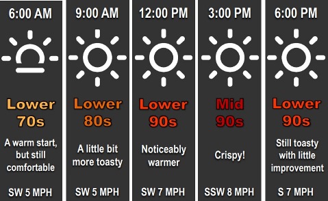
Hot weather continues this week, with a high near 94 today, according to the National Weather Service forecast.

The heat index will range from the low to upper 90s this week, the weather service said.

Dry weather is expected for most of the area at least through the end of the work week, according to the weather service. Rain is in the forecast for Friday night and Saturday.

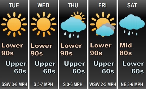
Today, it will be sunny with a high near 94 and a south southwest wind of 7 mph, the weather service said.

Tonight, it will be clear, with a low of 71 and a south wind of 5 to 7 mph, according to the weather service.

Wednesday, it will be sunny, with a high near 96 and a south wind of 6 to 9 mph, the weather service said.

Wednesday night, it will be mostly clear, with a low of 72 and a south wind around 6 mph, according to the weather service.

Thursday, it will be sunny with a high near 92 and a south wind of 3 to 7 mph, the weather service said.

Thursday night, it will be partly cloudy, with a low of 71, according to the weather service.

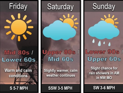
Friday, it will be sunny with a high near 94, the weather service said.

Friday night, there is a 30 percent chance of showers and thunderstorms after 1 a.m., with a low of 70, according to the weather service.

Saturday, there is a 30 percent chance of showers and thunderstorms, with a high near 84, the weather service said.

Saturday night, there is a 30 percent chance of showers and thunderstorms after 1 a.m., according to the weather service. The low will be around 64.

Sunday, there is a 40 percent chance of showers and thunderstorms, with a high near 84, the weather service said.

Sunday night, there is a 40 percent chance of showers and thunderstorms, with a low of 70, according to the weather service.

Monday, there is a 50 percent chance of showers and thunderstorms, with a high near 85, the weather service said.

Today’s weather: Return to summer

National Weather Service graphic

Hot weather is here again today, with a high of about 95, according to the National Weather Service.

The week will include more hot weather, with a heat index ranging from the low to upper 90s, the weather service said.

There will be dry weather through Friday night, when there is a chance for rain and storms, according to the weather service.

Today, it will be sunny with a high near 95 and a south southwest wind of 5 to 7 mph, the weather service said.

Tonight, it will be clear with a low around 71 and south wind of 5 to 7 mph, according to the weather service.

Tuesday, it will be sunny, with a high of 94 and a heat index as high as 97, the weather service said. A light south southwest wind will become southwest 5 to 9 mph in the morning.

Tuesday night, it will be clear with a low around 71, and a south wind 5 to 7 mph becoming calm in the evening, according to the weather service.

Wednesday, it will be sunny with a high near 94 and a calm wind becoming south southwest 5 to 7 mph in the morning, the weather service said.

Wednesday night, it will be mostly clear, with a low of 72, according to the weather service.

Thursday, it will be mostly sunny, with a high near 93, the weather service said.

Thursday night, it will be partly cloudy, with a low of 72, according to the weather service.

Friday, it will be mostly sunny, with a high near 94, the weather service said.

Friday night, there is a 30 percent chance of showers and storms after 2 a.m., with a low of 68, according to the weather service.

Saturday, there is a 30 percent chance of showers and thunderstorms, with a high near 86, the weather service said.

Saturday night, there is a 30 percent chance of showers and thunderstorms, with a low of 66, according to the weather service.

Sunday, there is a 40 percent chance of showers and thunderstorms, with a high near 84,the weather service said.

Temperatures begin to warm up again

National Weather Service graphic

Today, it’s summer again as temperatures may reach a high of 88, according to the National Weather Service.

The unseasonable cool weather in the past few days is changing, the weather service said.

An upper ridge will flatten out, and also expand eastward, allowing temperatures to rise to 90 on Saturday and the low to mid-90s on Saturday, according to the weather service. A weak front could lead to showers and storms Saturday night into Sunday, but it is uncertain at this time if Wyandotte County will get any rain.

Today, it will be sunny with a high near 88 and a south southwest wind of 3 to 6 mph, the weather service said.

Tonight, it will be clear, with a low of 65 and a south wind around 6 mph, according to the weather service.

Saturday, it will be sunny, with a high near 90 and a south southwest wind of 3 to 7 mph, the weather service said.

Saturday night, there is a 20 percent chance of showers and thunderstorms after 1 a.m., according to the weather service. The low will be around 69 with a calm wind becoming south around 5 mph after midnight.

Sunday, it will be sunny with a high near 92 and a southwest wind of 3 to 6 mph, the weather service said.

Sunday night, it will be mostly clear, with a low of 70, according to the weather service.

Monday, it will be sunny, with a high near 93, the weather service said.

Monday night, it will be clear with a low of 70, according to the weather service.

Tuesday, it will be sunny, with a high near 94, the weather service said.

Tuesday night, it will be mostly clear, with a low of 70, according to the weather service.

Wednesday, it will be sunny, with a high near 93, the weather service said.

Wednesday night, it will be mostly clear, with a low of 71, according to the weather service.

Thursday, it will be sunny with a high near 91, the weather service said.