Rain possible this weekend

Wyandotte County is in an area of marginal risk for severe storms tonight, according to the National Weather Service. The more severe storms should be to the north of the Kansas City area. (National Weather Service graphic)

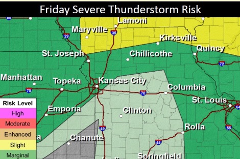
Late tonight, there is a slight possibility of thunderstorms, according to the National Weather Service.

After a warm and humid day on Friday, some cooler temperatures will be moving in, the weather service said.

The remnants of Hurricane Laura will stay to the southeast of the Kansas City region, according to the weather service.

A high pressure system is building in the lower Rockies, and a cold front will move across Kansas, arriving Saturday, according to the forecast.

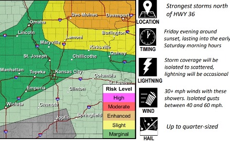
There could be some showers and storms late Friday into Saturday, the weather service said. The most severe of these storms will be mostly to the north of the Kansas City area.

The weather then becomes cooler and more active, according to the weather service. More chances for rain will come early next week.

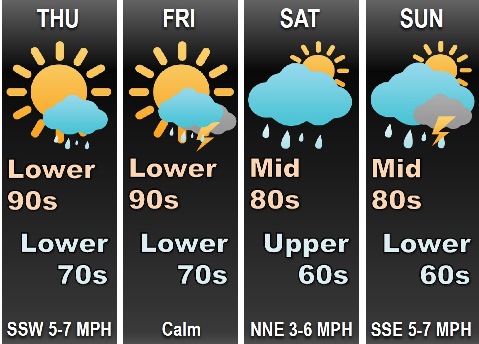
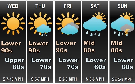
Today, it will be sunny with a high near 94 and a heat index as high as 99, the weather service said. A west wind will be 3 to 5 mph.

Tonight, there is a 30 percent chance of showers and thunderstorms, mainly between 1 a.m. and 4 a.m., according to the weather service. The low will be around 70 with a light and variable wind becoming north 5 to 9 mph after midnight.

Saturday, there is a 20 percent chance of showers and thunderstorms before 1 p.m., the weather service said. The high will be near 83 with a north wind of 7 to 10 mph.

Saturday night, there is a 20 percent chance of showers and thunderstorms after 1 a.m., according to the weather service. The low will be 62 with a north northeast wind of 5 to 7 mph, becoming calm after midnight.

Sunday, there is a 20 percent chance of showers and thunderstorms, with a high near 83, the weather service said. A calm wind will become east 5 to 7 mph in the morning.

Sunday night, there is a 50 percent chance of showers and thunderstorms, with a low of 68, according to the weather service. New rainfall amounts between a quarter and half-inch are possible.

Monday, there is a 70 percent chance of showers and thunderstorms, mainly before 1 p.m., with a high near 79, the weather service said.

Monday night, there is a 30 percent chance of showers and thunderstorms after 1 a.m., with a low of 59, according to the weather service.

Tuesday, there is a 40 percent chance of showers and thunderstorms, with a high near 76, the weather service said.

Tuesday night, there is a 40 percent chance of showers and thunderstorms, with a low of 59, according to the weather service.

Wednesday, there is a 30 percent chance of showers andthunderstorms, with a high near 79, the weather service said.

Wednesday night, it will be partly cloudy, with a low of 63, according to the weather service.

Thursday, it will be sunny, with a high near 81, the weather service said.

Sunny today, storms possible Friday

National Weather Service graphic
Hail, damaging winds and tornadoes are possible with a storm that will be to the north of Wyandotte County on Friday night. There is a 20 percent chance of showers and thunderstorms in Wyandotte County. (National Weather Service graphic)

The hot weather continues today, but there will be a break in temperatures on Saturday, according to the National Weather Service forecast.

Storms may move in on Friday afternoon and evening, the weather service said.

Temperatures will be in the mid-80s on Saturday, according to the weather service.

Hurricane Laura made landfall overnight in southeastern Louisiana, but won’t have much effect on this area currently, according to the weather service. On Friday, Laura will track across far southeastern Missouri, with cloud cover over the southeastern part of the region, the weather service said.

An upper-level wave will track across the northern plains and upper Midwest, pushing a cold front southward through Iowa and then to Missouri and Kansas on Friday evening, according to the weather service.

Today, it will be sunny with a high near 93 and a heat index as high as 99, with a south southwest wind of 9 mph, the weather service said.

Tonight, it will be mostly clear, with a low around 71 and a south wind of 5 to 7 mph becoming calm after midnight, according to the weather service.

Friday, it will be sunny, with a high near 94 and a heat index as high as 99, the weather service said. A light and variable wind will become west northwest around 5 mph in the afternoon.

Friday night, there will be a 20 percent chance of showers and thunderstorms, with a low of 70, according to the weather service. A calm wind will become north around 6 mph after midnight.

Saturday, it will be mostly sunny, with a high near 85 and a north northeast wind around 7 mph, the weather service said.

Saturday night, it will be partly cloudy, with a low of 63, according to the weather service.

Sunday, there will be a 30 percent chance of showers and thunderstorms after 1 p.m., the weather service said, with a high near 83.

Sunday night, there is a 60 percent chance of showers and thunderstorms, mostly after 1 a.m., with a low of 68.

Monday, there is a 70 percent chance of showers and thunderstorms, mainly before 1 p.m., with a high near 81, the weather service said.

Monday night, there is a 40 percent chance of showers and thunderstorms, with a low of 59, according to the weather service.

Tuesday, there is a 40 percent chance of showers and thunderstorms, with a high near 78, the weather service said.

Tuesday night, there is a 30 percent chance of showers and thunderstorms, with a low around 62, according to the weather service.

Wednesday, there is a 30 percent chance of showers and thunderstorms, with a high near 83, the weather service said.

Today’s heat index could be as high as 100

National Weather Service graphic

Today’s heat index in Wyandotte County could be as high as 100, according to the National Weather Service.

Above normal temperatures will continue through Friday, with today’s high near 96, the weather service said.

The southern and central portions of Missouri may get some rain from Hurricane Laura, according to the weather service, but at this time, Wyandotte County is not in that area.

On Friday night, there is a 20 percent chance of rain here, with more rain possible Sunday night, according to the weather service.

Today, it will be sunny, with a high near 96 and a heat index as high as 100, the weather service said. There wil be a south southwest wind of 7 to 11 mph.

Tonight, it will be mostly clear with a low of 73 and a south wind of 8 mph, according to the weather service.

Thursday, it will be mostly sunny, with a high near 92 and a heat index as high as 99, the weather service said. There will be a south southwest wind of 6 to 9 mph.

Thursday night, it will be mostly clear, with a low of 71 and a south southeast wind of 6 mph becoming calm after midnight, according to the weather service.

Friday, it will be sunny with a high near 93 and a light and variable wind, the weather service said.

Friday night, there is a 20 percent chance of showers and thunderstorms, with a low of 69, according to the weather service.

Saturday, it will be mostly sunny, with a high near 83, the weather service said.

Saturday night, it will be partly cloudy, with a low of 60, according to the weather service.

Sunday, it will be mostly sunny, with a high near 85, the weather service said.

Sunday night, there is a 50 percent chance of showers and thunderstorms, with a low of 68, according to the weather service.

Monday, there is a 60 percent chance of showers and thunderstorms, with a high near 83, the weather service said.

Monday night, there is a 40 percent chance of showers and thunderstorms, with a low of 64, according to the weather service.

Tuesday, there is a 40 percent chance of showers and thunderstorms, with a high near 80, the weather service said.