Cloudy, high near 58 today

National Weather Service graphic

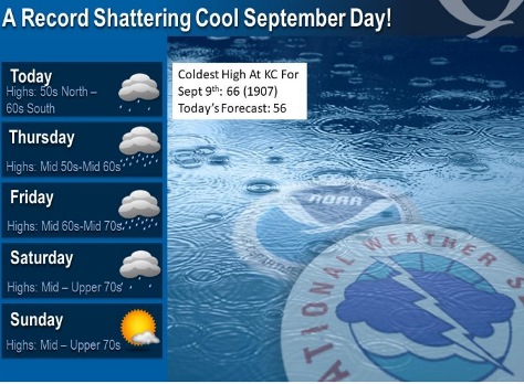
After some morning showers, today will be cool and cloudy, according to the National Weather Service forecast.

The high will be near 58 today, and it could be the coolest high temperature for Sept. 9 on record in Kansas City, the weather service stated. The previous record was 66 in 1907.

The chances of showers will continue on Thursday through Saturday, the weather service stated.

From 1 to 3 inches of precipitation is expected through Saturday, according to the weather service.

Today, after showers this morning, it will be cloudy with a high near 58 and a north northeast wind of 10 mph, the weather service said. Less than a tenth of an inch of rain is possible.

Tonight, there is a 60 percent chance of showers, mainly after 1 a.m., according to the weather service. The low will be around 53 with a north northeast wind of 8 to 10 mph, gusting as high as 20 mph. Between a quarter and half an inch of rain is possible.

Thursday, there is a 60 percent chance of showers, with a high near 61 and a north northeast wind of 7 to 9 mph, the weather service said. Between a tenth and quarter-inch of rain is possible.

Thursday night, there is a 40 percent chance of showers, mainly after 1 a.m., according to the weather service.The low will be around 58 with a north northeast wind of 6 mph becoming calm in the evening. Between a tenth and quarter-inch of rain is possible.

Friday, there is a 60 percent chance of showers, mainly after 1 p.m., the weather service said. The high will be near 71 with a calm wind becoming east southeast around 5 mph in the afternoon. Between a half and three-quarters of an inch of rain is possible.

Friday night, there is a 50 percent chance of showers, with a low of 62, according to the weather service. Between a tenth and quarter-inch of rain is possible.

Saturday, there is a 30 percent chance of showers after 1 p.m., with a high near 81, the weather service said.

Saturday night, it will be mostly clear, with a low of 59, according to the weather service.

Sunday, it will be sunny, with a high near 79, the weather service said.

Sunday night, it will be mostly clear, with a low of 57, according to the weather service.

Monday, it will be sunny with a high near 79, the weather service said.

Monday night, it will be mostly clear, with a low of 58, according to the weather service.

Tuesday, it will be sunny, with a high near 79, the weather service said.

Lower temperatures, rain likely through Saturday

National Weather Service graphic

Temperatures dropped to the 50s on Tuesday morning, with showers and thunderstorms possible today, according to the National Weather Service forecast.

Well below normal temperatures are expected this week, the weather service said. Today, temperatures may reach 63 in Wyandotte County.

Showers and thunderstorms will be possible throughout the day today, according to the weather service.

Chances for rain and storms continue all week, with 1 to 3 inches of rain expected through Saturday, the weather service said.

Temperatures may work their way back to 72 on Friday and 79 on Saturday, then end in the mid-70s for Sunday and Monday, according to the weather service.

Today, showers and thunderstorms are likely during the day, with a thunderstorm possible after 3 p.m., the weather service said. The high will be near 63 with a northeast wind of 10 to 14 mph, gusting as high as 22 mph. There is a 60 percent chance of precipitation. Between a tenth to quarter-inch of rain is possible.

Tonight, there is a 50 percent chance of showers and thunderstorms, with a low of 53, according to the weather service. A north northeast wind of 10 to 15 mph will gust as high as 23 mph. Between a tenth to quarter-inch of rain is possible.

Wednesday, there is a 30 percent chance of showers, with a high near 64 and a northeast wind of 9 mph, the weather service said. Less than a tenth of an inch of rain is forecast.

Wednesday night, there is a 40 percent chance of showers, with a low of 55 and a north northeast wind of 6 to 9 mph, according to the weather service. Less of a tenth of an inch of rain is likely.

Thursday, there is a 50 percent chance of showers, with a high near 65, and a north northeast wind of 7 mph, the weather service said. Less than a tenth of an inch of rain is possible.

Thursday night, there is a 40 percent chance of showers, then more chances of showers and thunderstorms after 1 a.m., according to the weather service. The low will be around 59. Between a tenth and quarter-inch of rain is possible.

Friday, there is a 50 percent chance of precipitation, with a high near 72, the weather service said.

Friday night, there is a 50 percent chance of showers and thunderstorms, with a low of 62, according to the weather service.

Saturday, there is a 50 percent chance of showers and thunderstorms, with a high near 79, the weather service said.

Saturday night, it will be mostly clear, with a low of 58, according to the weather service.

Sunday, it will be sunny, with a high near 76, the weather service said.

Sunday night, it will be partly cloudy, with a low of 55, according to the weather service.

Monday, it will be sunny, with a high near 76, the weather service said.

Temperatures could reach high of 93 today

Today’s high will be about 93, with a heat index of 96, according to the National Weather Service forecast.

Temperatures may reach a high of 93 today, with a heat index as high as 96, according to the National Weather Service.

Warm and humid weather continues today, and a cold front will move into the region from the north late Monday, bringing a chance of thunderstorms, the weather service said.

On Monday night, a few storms may be strong to severe, with damaging hail and wind possible with the strongest storms, according to the weather service.

Today, the high will be near 93 with a heat index as high as 96, the weather service said. It will be breezy, with a south southwest wind of 17 to 21 mph, gusting as high as 34 mph.

Tonight, it will be mostly clear, with a low of 70 and a southwest wind of 8 to 16 mph, gusting as high as 26 mph, according to the weather service.

Monday, Labor Day, there is a 20 percent chance of showers and thunderstorms after 3 p.m., according to the weather service. The high will be near 87, while an east northeast wind of 6 to 13 mph may gust up to 20 mph.

Monday night, there is a 60 percent chance of showers and thunderstorms, followed by more showers and a thunderstorm after 1 a.m., according to the weather service. The low will be around 59 with an east southeast wind of 9 to 11 mph becoming north northeast after midnight. Less than a tenth of an inch of rain is possible.

Tuesday, there is a 100 percent chance of showers and possibly a thunderstorm, the weather service said. The high will be near 67 with a north wind of 6 to 13 mph, gusting as high as 25 mph. Between a quarter and half-inch of rain is possible.

Tuesday night, there is an 80 percent chance of showers and possibly a thunderstorm before 1 a.m., then a chance of showers and thunderstorms between 1 a.m. and 4 a.m., followed by a chance of showers after 4 a.m., according to the weather service. The low will be around 50. Between a quarter and half-inch of rain is possible.

Wednesday, there is a 70 percent chance of showers, with a high near 58, the weather service said.

Wednesday night, there is a 30 percent chance of showers before 1 a.m., with a low of 50, according to the weather service.

Thursday, there is a 30 percent chance of showers and thunderstorms, with a high near 63, the weather service said.

Thursday night, there is a 30 percent chance of showers and thunderstorms, with a low of 53, according to the weather service.

Friday, there is a 30 percent chance of showers and thunderstorms, with a high near 67, the weather service said.

Friday night, it will be mostly cloudy, with a low of 53, according to the weather service.

Saturday, it will be mostly sunny, with a high near 72, the weather service said.