Forecast: High of 48, gusty north wind

National Weather Service graphic

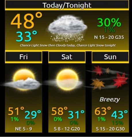
Light rain and wintry precipitation will exit the area by this afternoon, according to the National Weather Service forecast.

Gusty winds out of the north will continue through the day around 14 to 20 mph, gusting as high as 33, the weather service said.

Temperatures will rise to the 50s and 60s on the weekend, according to the weather service.

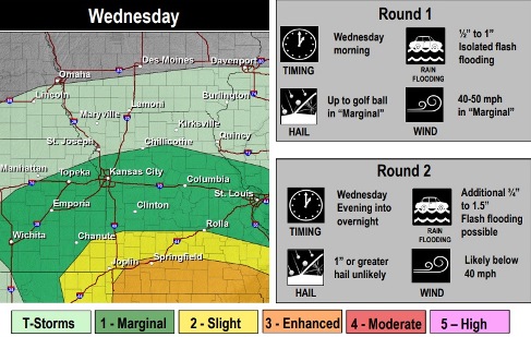
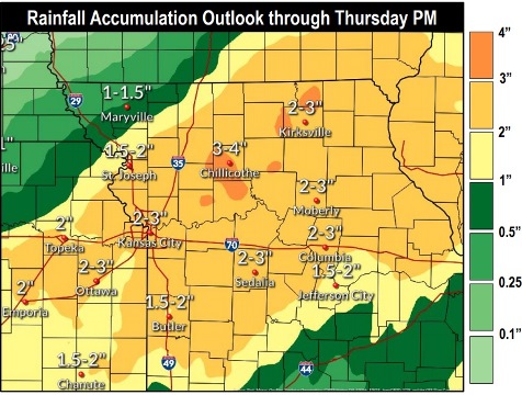
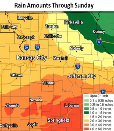
The next chance for rain will come early next week, with scattered showers and isolated thunderstorms, the weather service said.


Monday and Tuesday will see more than a 60 percent chance of rain, according to the weather service. Severe weather is not expected.

Today, there is a 20 percent chance of rain and snow before 11 a.m., the weather service said. The high will be near 48 with a north wind of 14 to 20 mph, gusting as high as 33 mph.

Tonight, it will be mostly clear, with a low of 28 and a north wind of 6 to 10 mph, according to the weather service.

Friday, it will be sunny, with a high near 51 and an east northeast wind of 7 mph, the weather service said.

Friday night, it will be mostly clear, with a low of 30 and an east wind of 3 to 6 mph, according to the weather service.

Saturday, it will be sunny, with a high near 58 and a south southeast wind of 6 to 13 mph, gusting as high as 21 mph, the weather service said.

Saturday night, it will be partly cloudy, with a low of 42, according to the weather service.

Sunday, it will be mostly sunny, with a high near 63 and breezy, the weather service said.

Sunday night, it will be mostly cloudy, with a low of 48, according to the weather service.

Monday, there is a 70 percent chance of rain, mainly after 1 p.m., with a high near 60, the weather service said.

Monday night, there is a 70 percent chance of rain, with a low of 49, according to the weather service.

Tuesday, there is a 60 percent chance of rain, with a high near 60, the weather service said.

Tuesday night, it will be partly cloudy, with a low of 42, according to the weather service.

Wednesday, it will be partly sunny, with a high near 58, the weather service said.

Rain, storms in forecast for St. Patrick’s Day

Wyandotte County is at a marginal risk for severe storms on Wednesday. Flash flooding is possible in some areas. (National Weather Service graphic)
From 2 to 3 inches of rain are possible through Thursday night. (National Weather Service graphic)

The St. Patrick’s Day forecast for Wyandotte County includes scattered thunderstorms and rain before 3 p.m. Wednesday, then more rain and possibly a thunderstorm, according to the National Weather Service.

Earlier this morning, rain moved through Wyandotte County, and is expected to return this afternoon and evening.

Tonight and into Thursday, snow and rain are possible, as the low will reach about 35, the weather service said.

Some isolated flash flooding is possible with tonight’s rain and snow, according to the weather service.

From 2 to 3 inches of precipitation is expected, leading to concerns about river flooding and isolated flash flooding, the weather service said.

Rain is next in the forecast on Sunday night through Tuesday, according to the weather service.

Today, there is a 90 percent chance of rain and thunderstorms before 3 p.m., then rain and possibly a thunderstorm, mainly after 3 p.m., the weather service said. The high will be near 50 with a north northeast wind of 13 to 20 mph, gusting as high as 28 mph. Between a half and three-quarters of an inch of rain is possible.

Tonight, there is a 100 percent chance of rain, possibly mixed with snow, with a low o f35, according to the weather service. A north wind of 20 to 23 mph will gust as high as 32. Little or no snow accumulation is expected.

Thursday, there is a 60 percent of snow and rain before 9 a.m., then a chance of rain, the weather service said. The high will be near 46 with a north northwest wind of 17 to 22 mph, gusting as high as 31 mph. Little or no snow accumulation is expected.

Thursday night, the low will be around 28 with a north wind of 6 to 11 mph, according to the weather service.

Friday, it will be sunny with a high near 52 and a northeast wind of 6 to 8 mph, the weather service said.

Friday night, it will be mostly clear, with a low of 32, according to the weather service.

Saturday, it will be sunny, with a high near 60, the weather service said.

Saturday night, it will be partly cloudy, with a low of 43, according to the weather service.

Sunday, it will be partly sunny, with a high near 64, and breezy, the weather service said.

Sunday night, there is a 30 percent chance of rain after 1 a.m., with a low of 49, according to the weather service.

Monday, there is a 60 percent chance of rain, with a high near 60, the weather service said.

Monday night, there is a 60 percent chance of rain, with a low of 48, according to the weather service.

Tuesday, there is a 40 percent chance of rain, with a high near 59, the weather service said.

For more information, visit www.weather.gov.

Forecast: Cooler today, rain Friday

Wyandotte County could receive more than 2 inches of rain through Sunday, according to the National Weather Service. (National Weather Service graphic)
A storm moved through Wyandotte County on Wednesday night, with lightning and rain.

Today’s weather will reach a high of 59, cooler than recent days, according to the National Weather Service.

A cold front has pushed through the area after last night’s rain. The cold front is expected to stay in the area into the first half of the weekend, with more rain expected in parts of the region, the weather service said.

In Wyandotte County, rain is in the forecast every day from Friday through Monday. Heavier rain is expected to fall south of the Missouri River, according to the weather service.

Some of the areas in the region are under a flood watch for Friday and Saturday, the weather service said.

Another round of showers and thunderstorms is possible on Sunday that could lead to additional flooding, according to the weather service.

Today, it will be partly sunny, with a high near 59 and a north wind of 7 to 9 mph, the weather service said.

Tonight, it will be partly cloudy, with a low of 40 and a northeast wind of 5 to 8 mph, according to the weather service.

Friday, there is an 80 percent chance of showers, mainly after noon, with a high near 52, the weather service said. An east wind of 9 to 15 mph will gust as high as 29 mph. Between a half and three-quarters of an inch of rain is possible.

Friday night, there is an 80 percent chance of rain with a low of 45, according to the weather service. An east wind of 10 to 15 mph will gust as high as 26 mph. Between a quarter and half-inch of rain is possible.

Saturday, there is a 90 percent chance of rain with a high near 55, the weather service said. An east southeast wind of 15 mph will gust as high as 23 mph. Between a quarter and half-inch of rain is possible.

Saturday night, there is a 90 percent chance of rain with a low of 48, according to the weather service. Between a half and three-quarters of an inch of rain is possible.

Sunday, there is a 90 percent chance of rain, with a high near 57, the weather service said.

Sunday night, there is a 70 percent chance of rain, mainly before midnight, according to the weather service. The low will be around 41.

Monday, there is a 40 percent chance of rain, with a high near 51, the weather service said.

Monday night, it will be mostly cloudy, with a low of 33, according to the weather service.

Tuesday, it will be partly sunny, with a high near 49, the weather service said.

Tuesday night, it will be mostly cloudy, with a low of 33, according to the weather service.

Wednesday, it will be mostly cloudy, with a high near 48, the weather service said.