Windy Wednesday will have high in 70s

Wind gusts of up to 33 mph are possible today, with a high of about 73. (National Weather Service graphic)

Today’s weather will be windy with a high of 73, according to the National Weather Service.

A dry cold front is moving through the region this morning, bringing lower temperatures tonight and on Thursday, the weather service said.

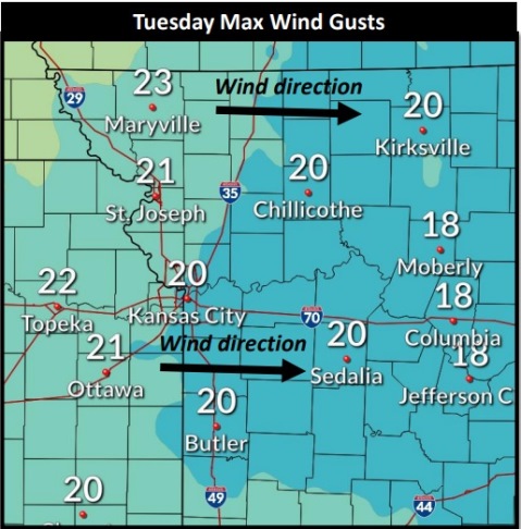
Wind gusts of up to 33 mph are possible this morning and in the early afternoon, before decreasing a little in the afternoon, according to the weather service.

Low relative humidity and strong winds will lead to near red-flag criteria across the region, so burning is discouraged, the weather service said.

This afternoon, the dry cold front moving through the region will mean that today’s high temperature will occur around 2 p.m. instead of later in the afternoon.

On Friday, patchy frost is possible in the early morning across the northern part of the state, according to the weather service. The low temperature on Thursday night and Friday morning could be about 40.

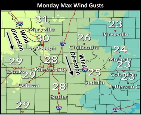
Today, it will be sunny with a high near 73, the weather service said. A west southwest wind of 10 to 18 mph will become north northwest in the morning, and winds may gust as high as 33 mph.

Tonight, it will be clear, with a low of 45 and a west wind of 7 mph, according to the weather service.

Thursday, it will be sunny with a high near 64, the weather service said. A north northwest wind of 9 to 15 may gust as high as 26 mph.

Thursday night, it will be mostly clear, with a low of 40, according to the weather service. A north northwest wind of around 6 mph will become calm in the evening.

Friday, it will be mostly sunny with a high near 64 and a light and variable wind, the weather service said.

Friday night, there is a 20 percent chance of sprinkles with a slight chance of showers after 1 a.m., according to the weather service. The low will be around 48.

Saturday, there is a 30 percent chance of showers with a high near 65, the weather service said.

Saturday night, it will be partly cloudy, with a low of 46, according to the weather service.

Sunday, it will be mostly sunny with a high near 60, the weather service said.

Sunday night, it will be mostly clear, with a low of 42, according to the weather service.

Monday, it will be sunny, with a high near 68, the weather service said.

Monday night, it will be mostly clear, with a low of 50, according to the weather service.

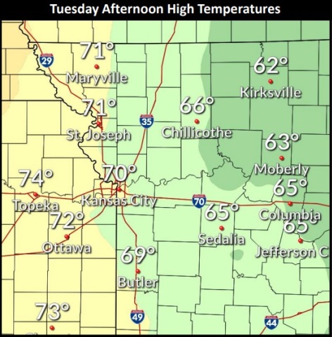
Tuesday, it will be sunny, with a high near 74, the weather service said.

Today’s weather: Windy, high of 70

The high temperature today may be 70, according to the National Weather Service forecast. (National Weather Service graphic)
A west wind of 6 to 11 mph today may gust up to 21 mph, according to the National Weather Service. (National Weather Service forecast)

The temperatures will warm up a little today, reaching a high of 70, with wind gusts expected this afternoon, according to the National Weather Service.

Wind gusts of up to 21 mph are possible today, the weather service said.

The warmer weather will continue Wednesday, but a dry cold front will push into the area from the north, according to the weather service.

Drier and cooler air will settle into the area Thursday and Friday, with highs in the 60s and lows in the 40s on Thursday morning, the weather service said.

On Thursday night, the low will be around 39. Frost may be possible on Friday morning close to the northern border of the state.

Weekend temperatures will be in the 60s, according to the weather service.

Today, it will be mostly sunny, with a high near 70 and a west wind of 6 to 11 mph, gusting as high as 21 mph, the weather service said.

Tonight, it will be mostly clear with a low of 52 and a west southwest wind of 6 to 9 mph, according to the weather service.

Wednesday, it will be sunny with a high near 76 and a west southwest wind of 7 to 17 mph becoming north northwest in the afternoon, the weather service said. Winds may gust up to 26 mph.

Wednesday night, it will be clear, with a low of 46 and a west northwest wind of 3 to 8 mph, according to the weather service.

Thursday, it will be sunny, with a high near 64, the weather service said. A north northwest wind will be 6 to 14 mph, gusting as high as 25 mph.

Thursday night, it will be mostly clear, with a low of 39, according to the weather service.

Friday, it will be sunny, with a high near 63, the weather service said.

Friday night, it will be mostly cloudy, with a low of 45, according to the weather service.

Saturday, it will be partly sunny, with a high near 68, the weather service said.

Saturday night, it will be partly cloudy, with a low of 46, according to the weather service.

Sunday, it will be mostly sunny, with a high near 65, the weather service said.

Sunday night, it will be mostly clear, with a low of 44, according to the weather service.

Monday, it will be sunny, with a high near 70, the weather service said.

Cooler temperatures, wind gusts in today’s forecast

Wind gusts as high as 28 mph are in today’s forecast. (National Weather Service graphic)

Today, temperatures will be cooler, with wind gusts as high as 28 mph, according to the National Weather Service forecast.

The entire week will be below average in temperatures, the weather service said. Today, high temperatures will be in the mid-60s.
A cold front moved into the area on Sunday, bringing rain and cooler temperatures, according to the weather service.

A secondary cold front moved through the region this morning, the weather service said.

Wind gusts of 28 mph are possible, as winds will pick up before noon today, according to the weather service.

Isolated rain showers are possible over the region this afternoon, the weather service said. At this time, rain is not appearing in the Wyandotte County forecast. Higher chances of precipitation will be east of I-35.

Tuesday and Wednesday may be a few degrees warmer, according to the weather service.

Thursday will return to the mid-60s, the weather service said. A cold front is set to move from north to south on Wednesday afternoon and evening.

Patchy frost may be possible toward the end of the week as temperatures drop into the upper 30s, according to the weather service. A low temperature of 39 degrees is possible Thursday night in Wyandotte County. It will be cooler north of the Missouri River.

Today, it will be mostly sunny, with a high near 66, the weather service said. A northwest wind of 8 to 17 mph will gust as high as 28 mph.

Tonight, it will be mostly cloudy, then gradually becoming mostly clear, with a low of 44, according to the weather service. A north northwest wind of 5 to 10 mph will become light northwest.

Tuesday, it will be sunny, with a high near 67 and a west northwest wind of 5 to 8 mph, the weather service said.

Tuesday night, it will be clear, with a low of 51 and a southwest wind of 6 mph, according to the weather service.

Wednesday, it will be sunny, with a high near 75, the weather service said. A light west wind will become northwest 5 to 10 mph in the morning, with winds gusting as high as 21 mph.

Wednesday night, it will be clear, with a low around 46, according to the weather service.

Thursday, it will be sunny, with a high near 63, the weather service said.

Thursday night, it will be clear, with a low of 39, according to the weather service.

Friday, it will be sunny, with a high near 61, the weather service said.

Friday night, it will be partly cloudy, with a low of 42, according to the weather service.

Saturday, there is a 30 percent chance of showers, with a high near 64, the weather service said.

Saturday night, it will be partly cloudy, with a low of 47, according to the weather service.

Sunday, it will be mostly sunny, with a high near 64, the weather service said.