Today’s weather: Cold, windy, with elevated fire risk

A drop in the relative humidity plus increased winds means an increase of fire risk on Friday and Saturday, according to the National Weather Service. (National Weather Service graphic)
There also is a risk of fire on Saturday, with increased wind gusts and decreased relative humidity. (National Weather Service graphic)

Temperatures of 37 degrees, with a little frost in places, greeted residents at 8 a.m. Friday.

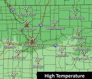
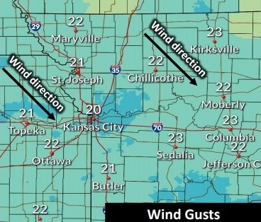
The wind chill was at 33 degrees at 8 a.m. Today’s temperatures will rise to about 62 degrees, and there is elevated fire risk, according to the National Weather Service forecast. Winds could gust as high as 23 mph today.

On Saturday, temperatures will be in the mid-70s. But lows will drop to about 37 on Sunday night and Monday night, according to the weather service.

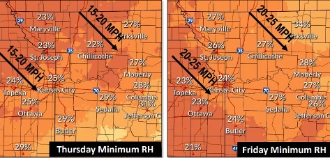
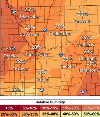
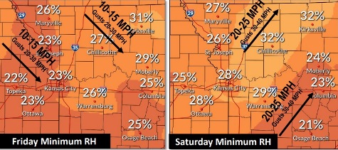
Today, humidity values will drop to 20 percent to 30 percent, with west winds of 5 to 11 mph, gusting as high as 23 mph, the weather service said.

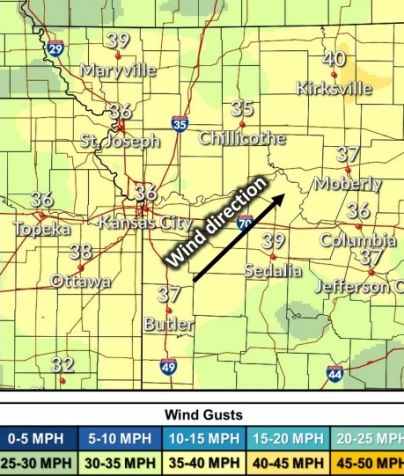
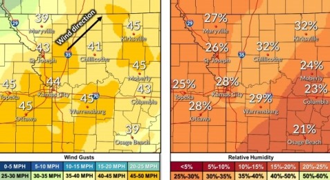
Significant fire weather danger also is expected Saturday, when humidity values may drop to 25 percent to 35 percent with southwesterly winds at 20 to 25, gusting to 45 mph, according to the weather service.

On Sunday, there is a 20 percent chance of rain, the weather service said.

Today, it will be sunny with a high near 62 and a west wind of 5 to 11 mph, gusting as high as 23 mph, the weather service said.

Tonight, it will be mostly clear, with a low of 49 and a south wind of 5 to 10 mph increasing to 13 to 18 mph after midnight, with wind gusts up to 24 mph, according to the weather service.

Saturday, it will be sunny with a high near 74, the weather service said. It will be breezy, with a south southwest wind of 20 to 25 mph, gusting as high as 45 mph.

Saturday night, it will be partly cloudy, with a low of 42 and a south southwest wind of 6 to 8 mph becoming north after midnight, according to the weather service.

Sunday, there is a 20 percent chance of rain, with a high near 51, the weather service said. A north northeast wind of 9 to 11 mph will gust as high as 20 mph.

Sunday night, it will be mostly cloudy, with a low of 37, according to the weather service.

Monday, it will be mostly cloudy, with a high near 51, the weather service said.

Monday night, it will be mostly cloudy, with a low of 37, according to the weather service.

Tuesday, there is a 30 percent chance of showers and thunderstorms after 1 p.m., the weather service said. The high will be near 58.

For more weather information, visit www.weather.gov.

Elevated fire weather possible today, as temperatures drop 20 degrees

Relative humidity is dropping Thursday and Friday, leading to elevated fire weather. (National Weather Service graphic)
Temperatures could reach a high of 59 today. (National Weather Service graphic)
A north northwest wind of 10 to 13 mph may gust as high as 21 mph today. (National Weather Service graphic)

Elevated fire weather danger is possible this afternoon, as temperatures have dropped about 20 degrees this morning, according to the National Weather Service forecast.

The temperature was 51 degrees at 9 a.m. Thursday. Today’s temperatures will reach a high near 59, a sharp contrast to Wednesday, when temperatures reached the 80s, the weather service said.

This afternoon, humidity values will drop into the 20 percent to 30 percent range with northwesterly winds gusting to about 21 mph, according to the weather service.

Elevated fire weather danger also is expected on Friday and Saturday, the weather service said. On Friday, humidity values will drop to 20 percent to 30 percent with northwesterly wind gusts to 25 mph. Saturday, humidity values will drop to 25 percent to 35 percent, with southwesterly winds gusting to about 35 mph.

Although there is no freeze warning for Wyandotte County, temperatures could drop to a low of about 38 degrees tonight, according to the weather service. There might be frost on Friday morning.

Late Saturday or early Sunday, a front will push into the region, and could bring some light rain next week, although it is too early to say for certain. Next week will bring cooler temperatures and more fall-like weather, according to the weather service.

Today, it will be sunny with a high near 59 and a north northwest wind of 10 to 13 mph, gusting as high as 21 mph, the weather service said.

Tonight, it will be mostly clear, with a low of 38 and a north northwest wind of 6 mph becoming calm, according to the weather service.

Friday, it will be sunny with a high near 61 and a west northwest wind of 6 to 13 mph, gusting as high as 22 mph, the weather service.

Friday night, it will be partly cloudy, with a low of 47 and a light southwest wind becoming south 8 to 13 mph in the evening, according to the weather service. Winds may gust as high as 22 mph.

Saturday, It will be mostly sunny, with a high near 72, the weather service said. It will be breezy, with a south southwest wind of 15 to 20 mph, gusting as high as 36 mph.

Saturday night, it will be partly cloudy, with a low around 44, according to the weather service.

Sunday, it will be mostly cloudy, with a high near 55, the weather service said.

Sunday night, it will be mostly cloudy, with a low of 42, according to the weather service.

Monday, there is a 30 percent chance of rain before 1 p.m., the weather service said. The high will be near 54.

Monday night, it will be mostly cloudy, with a low of 40, according to the weather service.

Tuesday, it will be partly sunny, with a high near 56, the weather service said.

Tuesday night, it will be mostly cloudy, with a low of 44, according to the weather service.

Wednesday, it will be partly sunny, with a high near 62, the weather service said.

Weather: High in 80s, risk of fire increases today

Winds could gust as high as 38 mph today in Wyandotte County. Dry and windy conditions create a greater chance of fire. (National Weather Service graphic)
Relative humidity could drop to about 28 percent today. The dry and windy conditions create a greater risk of fire. (National Weather Service graphic)

The risk of fire is increasing on Wednesday, with winds gusting as high as 38 mph and relative humidity dropping this afternoon, according to the National Weather Service forecast.

An area to the southeast of Wyandotte County is under a red flag warning today for fire weather, but that warning is not in place for Wyandotte County.

Typical fall weather returns to the area on Thursday.

Temperatures will drop about 20 degrees or so on Thursday, as a cold front moves through the area, the weather service said. Temperatures may reach a low of 37 early Friday morning.

There is a potential for frost in the region, but at this time, the Wyandotte County forecast does not show any temperatures falling below freezing this week.

Today, it will be sunny with a high near 84, the weather service said. It will be breezy, with a south southwest wind of 10 to 20 mph gusting as high as 38 mph.

Tonight, the low will be around 49 with a north northwest wind of 11 mph, gusting as high as 18 mph, according to the weather service.

Thursday, it will be mostly cloudy through mid-morning, then gradually clearing, with a high near 60, the weather service said. A north northwest wind of 10 to 14 mph will gust as high as 20 mph.

Thursday night, it will be mostly clear, with a low of 37 and a north northwest wind of 5 mph becoming calm in the evening, according to the weather service.

Friday, it will be sunny, with a high near 61 and a light west southwest wind becoming west northwest 6 to 11 mph in the morning, the weather service said. Winds may gust as high as 23 mph.

Friday night, it will be partly cloudy with a low of 46, according to the weather service.

Saturday, it will be mostly sunny, with a high near 70, and breezy, the weather service said.

Saturday night, it will be partly cloudy, with a low of 43, according to the weather service.

Sunday, it will be partly sunny, with a high near 56, the weather service said.

Sunday night, it will be partly cloudy, with a low around 39, according to the weather service.

Monday, it will be mostly sunny, with a high near 54, the weather service said.

Monday night, it will be partly cloudy, with a low of 38, according to the weather service.

Tuesday, it will be mostly sunny, with a high near 58, the weather service said.