Today’s weather: Rain, high near 54

Rain is in the forecast in the area. (National Weather Service graphic)

Rain returns to the area today, with a chance of drizzle throughout the day, according to the National Weather Service. A strong cold front moves in Thursday night and Friday morning, with the possibility of damaging winds.

There is a possibility of showers and thunderstorms after 4 p.m., according to the weather service. Rain chances will continue through the week.

Today’s high will be near 54, with temperatures rising each day through Thursday, when they may reach the 80s, the weather service said.

Friday night’s low will be close to freezing, at 34 degrees, according to the forecast. Frost is possible on Saturday morning. Cool weather is forecast for the weekend, with highs around 50.

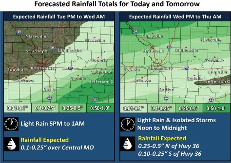
Today, there is a 30 percent chance of drizzle before 1 p.m., then a slight chance of drizzle and thunderstorms between 1 p.m. and 4 p.m., followed by a chance of showers and thunderstorms after 4 p.m., the weather service said. The high will be near 54 with an east wind of 5 to 7 mph becoming light and variable in the afternoon.

Tonight, there is a 20 percent chance of showers and thunderstorms, mainly between 10 p.m. and 1 a.m., according to the weather service. The low will be around 41 with a calm wind.

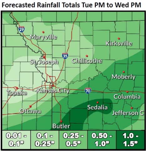
Wednesday, there is a 20 percent chance of showers, with thunderstorms also possible after 1 p.m., the weather service said. The high will be near 59 with an east wind of 3 to 8 mph.

Wednesday night, it will be mostly cloudy, with temperatures rising to about 65 by 2 a.m., according to the weather service. An east wind of 8 to 14 mph will become south after midnight, with winds gusting as high as 23 mph.

Thursday, it will be sunny, with a high near 83, the weather service said. It will be breezy, with a south wind of 15 to 24 mph, gusting as high as 43 mph.

Thursday night, there is a 50 percent chance of showers and thunderstorms, with a low of 41, according to the weather service. Between a tenth and quarter-inch of rain is possible.

Friday, it will be partly sunny, with a high near 50, the weather service said.

Friday night, there may be areas of frost after 5 a.m., according to the weather service. The low will be around 34.

Saturday, it will be partly sunny, with a high near 50, the weather service said

Saturday night, it will be mostly cloudy, with a low of 41, according to the weather service.

Sunday, there is a 30 percent chance of showers and thunderstorms, with a high near 54, the weather service said.

Sunday night, there is a 30 percent chance of showers nad thunderstorms, with a low of 37, according to the weather service.

Monday, there is a 30 percent chance of showers and thunderstorms, with a high near 43, the weather service said.

Cool temperatures today, rain possible Tuesday

Wyandotte County may get less than a tenth of an inch of rain on Tuesday. (National Weather Service graphic)
An east northeast wind of 7 to 9 mph, gusting in the teens, is in Monday’s forecast. (National Weather Service graphic)

Temperatures today may reach a high of 48, with rain in the forecast for Tuesday, according to the National Weather Service forecast.

It was 42 degrees at 9 a.m., with a wind chill of 35.

Temperatures will rise each day through Thursday, then drop off Thursday night, the weather service forecast said. Thursday, temperatures may reach into the 80s. Friday night, temperatures could decline to 36 degrees.

Look for a 50 percent chance of scattered rain showers on Tuesday afternoon into Wednesday morning, according to the weather service.

Today, it will be cloudy with a high near 48 and an east northeast wind of 7 to 9 mph, the weather service said.

Tonight, it will be mostly cloudy, with a low of 41 and an east wind of 5 to 7 mph, according to the weather service.

Tuesday, there is a 50 percent chance of showers after 1 p.m., with a high near 55, and an east wind of 3 to 8 mph, the weather service said. Less than a tenth of an inch of rain is possible.

Tuesday night, there is a 30 percent chance of showers, mainly before 1 a.m., with a low of 46, and a calm wind, according to the weather service. Less than a tenth of an inch of rain is possible.

Wednesday, there is a 20 percent chance of showers, with a high near 68, and an east southeast wind of 3 to 8 mph, the weather service said.

Wednesday night, it will be partly cloudy with a low of 62, according to the weather service.

Thursday, it will be mostly sunny, with a high near 81 and breezy, the weather service said.

Thursday night, there is a 50 percent chance of showers and thunderstorms, with a low of 47, according to the weather service.

Friday, there is a 30 percent chance of showers before 1 p.m., with a high near 55, the weather service said.

Friday night, it will be mostly cloudy, with a low of 36, according to the weather service.

Saturday, it will be partly sunny, with a high near 51, the weather service said.

Saturday night, it will be mostly cloudy, with a low of 41, according to the weather service.

Sunday, there is a 30 percent chance of showers, with a high near 59, the weather service said.

Fire danger increases with windy weather today

Wind gusts of up to 46 mph are possible Saturday, according to the National Weather Service. Wyandotte County is under a wind advisory through 3 p.m. Saturday. (National Weather Service graphic)

Open burning is discouraged on Saturday because of strong winds, low relative humidity and recent dry conditions, according to the National Weather Service.

Winds could gust up to 46 mph today, according to the weather service forecast.

Residents are asked to use extra caution when driving, especially if operating a high profile vehicle, the weather service said. Residents should secure outdoor objects, according to the weather service.

A wind advisory is in effect in Wyandotte County from 9 a.m. through 3 p.m. Saturday, the weather service said.

A red flag warning is in effect in areas to the south and east of Wyandotte County, but not in Wyandotte County, according to weather service information.

Winds may shift to the north northeast as a cold front moves through tonight, the weather service said.

There is a slight, 20 percent chance of rain on Sunday, according to the weather service.

Today, it will be sunny with a high near 75. Winds will be south southwest from 18 to 25 mph, gusting as high as 46 mph, the weather service said.

Tonight, it will be partly cloudy with a low of 43 and a southwest wind of 6 to 13 mph becoming north northeast after midnight, according to the weather service. Winds may gust as high as 21 mph.

Sunday, there is a 20 percent chance of rain with a high near 50, the weather service said. A north northeast wind of 13 to 16 mph will gust as high as 28 mph.

Sunday night, it will be cloudy, with a low of 39, and a northeast wind of 8 mph, according to the weather service.

Monday, it will be mostly cloudy, with a high near 50 and an east northeast wind of 7 to 9 mph, the weather service said.

Monday night, it will be partly cloudy, with a low of 38, according to the weather service.

For more weather information, visit www.weather.gov.