Freeze warning issued for tonight

A freeze warning will be in effect tonight. (National Weather Service graphic)
Wintry precipitation is possible on Monday. (National Weather Service graphic)

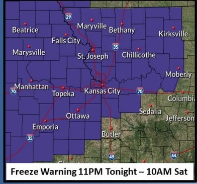
A freeze warning has been issued for 11 p.m. tonight through 10 a.m. Saturday, according to the National Weather Service.

The first freeze of the season is expected for most of the area tonight, the weather service said.. Sensitive vegetation will need to be protected to avoid damage or death.

Residents are advised to wrap or drain outdoor water pipes to avoid freezing and possible bursting of pipes, according to the weather service.

Residents who have in-ground sprinkler systems should drain them and cover above-ground pipes to protect them from freezing, the weather service said.

Showers may continue through 10 a.m. Friday, with today’s high reaching 45 degrees, according to the weather service.

Well below normal temperatures are expected through the weekend, the weather service said.

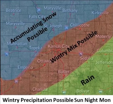
Wintry precipitation may affect the entire area late Sunday night into Monday. There is a chance of snow on Monday, according to the weather service.

Today, there is a 30 percent chance of showers, mainly before 10 a.m., the weather service said. The high will be near 45 with a north wind of 16 mph, gusting as high as 30 mph. Less than a tenth of an inch of rain is possible.

Tonight, areas of frost are possible before 3 a.m., and after 4 a.m., according to the weather service. The low will be around 31 with a north wind of 6 to 11 mph.

Saturday, there could be widespread frost before 10 a.m., the weather service said. The high will be near 48 with an east wind of 7 to 9 mph.

Saturday night, it will be mostly cloudy, with a low of 39, according to the weather service, and an east wind of 6 to 8 mph.

Sunday, there is a 40 percent chance of rain, with a high near 47 and an east wind of 9 mph, the weather service said. Between a tenth and quarter of an inch of rain is possible.

Sunday night, there is a 30 percent chance of rain, mainly after 1 a.m., with a low of 29, according to the weather service. Less than a tenth of an inch of rain is possible.

Monday, there is a 30 percent chance of snow, with a high near 33, the weather service said.

Monday night, it will be mostly cloudy, with a low of 23, according to the weather service.

Tuesday, it will be partly sunny, with a high near 38, the weather service said.

Tuesday night, it will be partly cloudy, with a low of 30, according to the weather service.

Wednesday, it will be mostly sunny, with a high near 52, the weather service said.

Wednesday night, it will be mostly cloudy, with a low of 37, according to the weather service.

Thursday, it will be partly sunny, with a high near 53, the weather service said.

Storms in tonight’s forecast, wind advisory in effect

There is a marginal risk of storms tonight in Wyandotte County. (National Weather Service graphic)
A wind advisory is in effect today from 9 a.m. to 5 p.m.. (National Weather Service graphic)

Today’s forecast from the National Weather Service includes possible storms tonight, and a wind advisory from 9 a.m. to 5 p.m.

A strong cold front with storms will move through the area in the evening, and some storms could develop with severe wind gusts and large hail, the weather service said.

Winds may gust as high as 43 mph this afternoon, according to the weather service.

Today’s high will be near 83, and this will be the last day in the 80s through the next week, the forecast stated. Temperatures will drop to a low of 39 tonight, and a high of 47 on Friday.

It’s time to bring in the outdoor plants and the last of the garden vegetables, as the low will reach 32 on Friday night. There is a chance of frost on Friday night and Saturday morning, according to the weather service. Snow is possible on Monday and Tuesday.

There is a 10 percent chance of showers after 5 p.m. today, with a high near 83 during the day. It will be breezy, with a south southwest wind at 9 to 14 mph increasing to 19 to 24 mph in the afternoon, the weather service said. Winds may gust as high as 43 mph.

Tonight, there is a 80 percent chance of showers and thunderstorms likely before 10 p.m., then showers and possibly a thunderstorm between 10 p.m. and 4 a.m., then showers likely after 4 a.m., according to the weather service. The low will be around 39 with a south southwest wind of 10 to 16 mph, becoming north northwest after midnight. Winds may gust as high as 22 mph. Between a quarter and half-inch of rain is possible.

Friday, there is a 60 percent chance of showers before 7 a.m., the weather service said. The high will be near 47 with a north wind of 14 to 16 mph, gusting as high as 23 mph. Less than a tenth of an inch of rain is possible.

Friday night, areas of frost will be possible before 3 a.m., then widespread frost after 4 a.m., according to the weather service. The low will be around 32 with a north northeast wind of 4 to 9 mph.

Saturday, widespread frost is possible before 8 a.m., the weather service said. The high will be near 49 with an east wind of 6 to 9 mph.

Saturday night, there is a 20 percent chance of showers after 1 a.m., with a low of 44, according to the weather service.

Sunday, there is a 50 percent chance of showers possible, with a high near 50, the weather service said.

Sunday night, there is a 40 percent chance of rain showers before 2 a.m., then a chance of rain and snow showers, according to the weather service. The low will be around 30.

Monday, there is a 30 percent chance of snow showers before 1 p.m., the weather service said. The high will be near 36.

Monday night, widespread frost is possible before 3 a.m., then widespread frost after 4 a.m., according to the weather service. The low will be around 24.

Tuesday, there is a 30 percent chance of rain and snow showers, with a widespread frost, the weather service said. The high will be near 39.

Tuesday night, there will be widespread frost, with a low of 28, according to the weather service.

Wednesday, there will be widespread frost, with a high near 48, the weather service said.

Rain, fog, high of 58 in today’s forecast

There may be light rain on Wednesday and Thursday night. (National Weather Service graphic)
Fog over I-70 and I-635 on Wednesday morning. (KC Scout photo)

Wyandotte County saw some dense fog this morning, mainly along and north of I-70.

The National Weather Service forecast calls for rain and a high of about 58 today.

Temperatures will rise to near 82 on Thursday, before falling again, with Friday’s high near 48, the weather service said.

Friday night’s low will be just above freezing, at about 35 degrees, according to the weather service.

Today, there is a 30 percent chance of showers and thunderstorms, mainly between 10 a.m. and noon, the weather service said. A patchy dense fog may continue through 9 a.m. The high will be near 58 with a calm wind becoming east 5 to 8 in the morning.

Tonight, there is a 30 percent chance of showers and thunderstorms before 1 a.m., with a patchy fog in the early morning hours, according to the weather service. The low will be around 54 with an east wind of 6 to 8 mph becoming south after midnight. Less than a tenth of an inch of rain is expected.

Thursday, it will be sunny with a high near 82 and it will be breezy with a south southwest wind of 14 to 23 mph, gusting as high as 39 mph, the weather service said.

Thursday night, there is a 60 percent chance of showers and thunderstorms likely, with a low of 41, according to the weather service. A south southwest wind of 9 to 15 mph will become north northwest after midnight, and gust as high as 20 mph. Between a quarter and half-inch of rain is possible.

Friday, there will be a 20 percent chance of showers and thunderstorms before 1 p.m., the weather service said. The high will be near 48 with a north wind of 13 to 15 mph, gusting to 22 mph.

Friday night, it will be mostly cloudy with a low of 35, according to the weather service.

Saturday, there may be areas of frost before 10 a.m., with a high near 48, the weather service said.

Saturday night, it will be cloudy, with a low of 43, according to the weather service.

Sunday, there is a 40 percent chance of showers with a high near 54, the weather service said.

Sunday night, there is a 40 percent chance of showers with a low of 35, according to the weather service.

Monday, there is a 40 percent chance of showers, with a high near 41, the weather service said.

Monday night, there is a 30 percent chance of rain and snow showers, with a low around 30, according to the weather service.

Tuesday, there is a 50 percent chance of rain and snow showers, with a high near 41, the weather service said.