Thunderstorms possible today

Wyandotte County is at risk for thunderstorms today. (National Weather Service graphic)
Wyandotte County could see thunderstorms around noon today. (National Weather Service graphic)

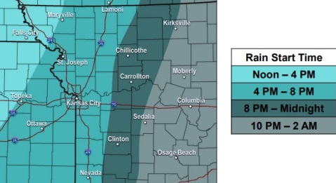
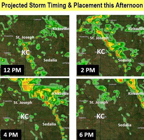
Additional showers and thunderstorms are expected to develop by late morning and continue through the afternoon hours, according to the National Weather Service.

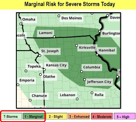
A few storms could be strong to severe, the weather service said. The Kansas City area has a risk of thunderstorms. Winds may gust up to 21 mph.

The main threats could be a brief tornado and hail up to quarter-size throughout the region, according to the weather service.

Severe weather is possible from 11 a.m. to 6 p.m. The weather service said that the timing of the storms could be around noon in the Kansas City area.

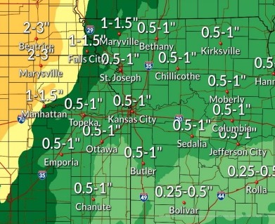
Between a quarter and half-inch of rain could fall today, according to the weather service.

At 9 a.m., it was overcast in Wyandotte County.

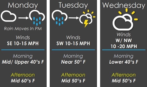
Today, there is a 90 percent chance of rain, with thunderstorms also possible after 1 p.m., the weather service said. The high will be near 60, with an east wind of 9 to 13 mph becoming south in the afternoon. Winds may gust up to 21 mph. Between a quarter and half-inch of rain may fall.

Tonight, there is an 80 percent chance of rain, mainly before 7 p.m., according to the weather service. The low will be around 45 with a southwest wind of 8 to 13 mph. Less than a tenth of an inch of rain is possible.

Wednesday, it will be mostly cloudy, with a high near 53 and a west wind of 10 to 14 mph, gusting up to 18 mph, the weather service said.

Wednesday night, there is a 30 percent chance of rain, with a low of 40, according to the weather service. A north northwest win of 6 mph will become light and variable. Less than a tenth of an inch of rain is likely.

Thursday, there is a 20 percent chance of rain after 1 p.m., the weather service said. The high will be near 53. A north northeast wind will be 5 to 8 mph.

Thursday night, there is a 20 percent chance of rain before 1 a.m., with a low of 37, according to the weather service.

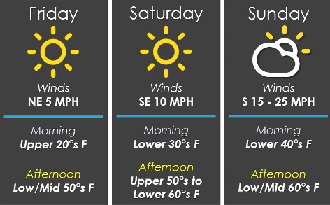
Friday, it will be partly sunny, with a high near 60, the weather service said.

Friday night, there is a 50 percent chance of rain, with a low of 46, according to the weather service.

Saturday, it will be mostly sunny, with a high near 64, the weather service said.

Saturday night, it will be mostly clear, with a low of 42, according to the weather service.

Sunday, it will be sunny, with a high near 62, the weather service said.

Sunday night, it will be mostly clear, with a low of 41, according to the weather service.

Monday, it will be sunny, with a high near 66, the weather service said.

For more weather information, visit www.weather.gov.

Today’s high near 63, rain in forecast

National Weather Service graphic
Wyandotte County could get from a half-inch to an inch of rain today through Tuesday. (National Weather Service graphic)
Rain is expected to start this evening. (National Weather Service graphic)

Patchy drizzle is in the forecast for Monday before 10 a.m., with temperatures reaching a high near 63 today, according to the National Weather Service.

Rain chances will build from east to west, reaching Wyandotte County by the evening, possibly around 6 p.m., the weather service said. The best chances for rain will be overnight through Tuesday morning.

Between today and Tuesday, widespread rainfall of half an inch to an inch is possible across the area, according to the weather service. There could be localized increases in streams and rivers.

Scattered thunder is expected on Tuesday, the weather service said. A few strong storms midday Tuesday into the afternoon cannot be ruled out at this time.

Today, there could be patchy drizzle before 10 a.m., with a high this afternoon near 63, the weather service said. A south southeast wind of 5 to 14 mph will gust as high as 23 mph.

Tonight, there is a 90 percent chance of rain, with a low of 51, according to the weather service. A southeast wind of 10 to 14 mph will gust as high as 22 mph. Between a tenth and quarter-inch of rain is possible.

Tuesday, there is a 90 percnet chance of rain, and possibly a thunderstorm, the weather service said. The high will be near 59 with a south wind of 10 to 15 mph, gusting as high as 24 mph. Between a quarter and half-inch of rain is possible.

Tuesday night, it will be mostly cloudy, with a low of 44, according to the weather service. A west southwest wind of 11 to 14 mph will gust as high as 20 mph.

Wednesday, it will be mostly cloudy, with a high near 56, the weather service said. A west wind of 10 to 13 mph will gust as high as 20 mph.

Wednesday night, there is a 40 percent chance of rain, with a low of 41, according to the weather service. Between a tenth and quarter-inch of rain is possible.

Thursday, there is a 30 percent chance of rain, with a high near 52, the weather service said.

Thursday night, there is a 30 percent chance of rain before 1 a.m., with a low of 38, according to the weather service.

Friday, it will be partly sunny, with a high near 58, the weather service said.

Friday night, there is a 30 percent chance of rain before 1 a.m., with a low of 43, according to the weather service.

Saturday, it will be mostly sunny, with a high near 63, the weather service said.

Saturday night, it will be mostly clear, with a low of 42, according to the weather service.

Sunday, it will be sunny, with a high near 60, the weather service said.

Cool start today, weekend temperatures to rise to 50s and 60s

National Weather Service graphic

With a freezing start to Friday, temperatures today should reach 54 by 5 p.m., according to the National Weather Service forecast.

The temperature at 8 a.m. was a cold 30 degrees, with a wind chill index of 25, the weather service said.

Temperatures will rise to 59 on Saturday and 64 on Sunday, according to the weather service forecast. Winds will gust up to 30 mph on Sunday.

Rain will be possible Sunday night through Tuesday night, the weather service said.

Today, it will be sunny with a high near 54 and an east northeast wind of 5 to 7 mph, the weather service said.

Tonight, it will be clear, with a low of 31 and an east southeast wind of 3 to 6 mph, according to the weather service.

Saturday, it will be sunny with a high near 59 and a south southeast wind of 5 to 13 mph, gusting as high as 21 mph, the weather service said.

Saturday night, it will be partly cloudy, with a low of 43 and a south southeast wind of 9 to 11 mph, gusting as high as 20 mph, according to the weather service.

Sunday, it will be mostly sunny, with a high near 64 and a south wind of 13 to 20 mph, gusting to 30 mph, the weather service said.

Sunday night, there is a 20 percent chance of rain after 1 a.m., with a low of 48, according to the weather service.

Monday, there is a 70 percent chance of rain, with a high near 59, the weather service said.

Monday night, there is an 80 percent chance of rain, with a low of 49, according to the weather service.

Tuesday, there is a 70 percent chance of rain, with a high near 58, the weather service said.

Tuesday night, there is a 30 percent chance of rain before 1 a.m., with a low of 40, according to the weather service.

Wednesday, it will be mostly sunny, with a high near 58, the weather service said.

Wednesday night, it will be partly cloudy, with a low of 38, according to the weather service.

Thursday, it will be mostly sunny, with a high near 61, the weather service said.