Dense fog advisory in effect Tuesday morning

A dense fog advisory is in effect Tuesday morning in Wyandotte County. (National Weather Service graphic)
Fog over the Missouri River on I-635 on Tuesday morning. (KC Scout photo)

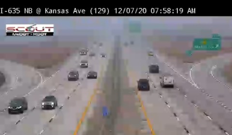
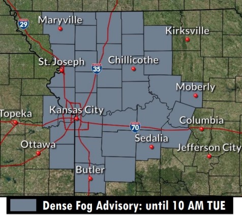
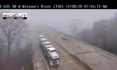
A dense fog advisory is in effect until 10 a.m. Tuesday in Wyandotte County, according to the National Weather Service.

Visibilities may be a quarter mile or less, the weather service said.

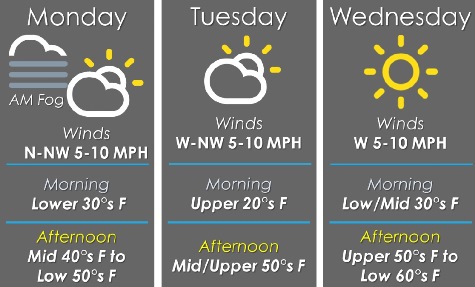
Quiet weather continues on Tuesday, with a high today near 57, warming to the 60s on Wednesday, according to the weather service.

Rain chances will increase Thursday night through Friday, the weather service said.

Today, there will be areas of dense freezing fog this morning, ending by 10 a.m., the weather service said. It will be sunny later in the day, with a high near 57 and a calm wind becoming west southwest 5 to 8 mph in the afternoon.

Tonight, it will be mostly clear, with a low of 35 and a west southwest wind of 5 to 7 mph, according to the weather service.

Wednesday, it will be sunny, with a high near 65 and a west southwest wind of 5 to 7 mph becoming northwest in the afternoon, the weather service said.

Wednesday night, it will be clear, with a low of 36 and a light and variable wind, according to the weather service.

Thursday, it will be increasingly cloudy, with a high near 62 and a south wind of 3 to 7 mph, the weather service said.

Thursday night, there is a 30 percent chance of rain after midnight, with a low of 40, according to the weather service. Less than a tenth of an inch of precipitation is in the forecast.

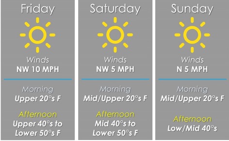
Friday, there is a 40 percent chance of rain, with a high near 48, the weather service said.

Friday night, it will be cloudy, with a low of 33, according to the weather service.

Saturday, it will be mostly cloudy, with a high near 39, the weather service said.

Saturday night, it will be mostly cloudy, with a low of 24, according to the weather service.

Sunday, it will be mostly sunny, with a high near 39, the weather service said.

Sunday night, it will be mostly clear, with a low of 24, according to the weather service.

Monday, it will be mostly sunny, with a high near 46, the weather service said.

Foggy start to Monday, high near 52

National Weather Service graphic
Cars made their way to work through the fog this morning on I-635 near Kansas Avenue. (KC Scout photo)

After a foggy start to the day, the high will rise to about 52 degrees, according to the National Weather Service forecast.

Limited visibility in the morning could result in hazardous driving conditions, the weather service said.

Quiet weather will continue this week, warming through the midweek, according to the weather service. Temperatures could reach 62 by Wednesday.

Rain chances will increase late Thursday through Friday, the weather service said.

Today, patchy fog is possible between 9 a.m. and 10 a.m., with some patchy freezing fog possible early. It will be partly sunny, then gradually sunny, with a high near 52 and a southwest wind of 5 to 7 mph becoming northwest in the afternoon, the weather service said.

Tonight, it will be clear, with a low of 30 and a west northwest wind of 3 to 5 mph, according to the weather service.

Tuesday, it will be sunny, with a high near 56 and a west northwest wind of 5 to 8 mph, the weather service said.

Tuesday night, it will be mostly clear, with a low of 36 and a west southwest wind around 6 mph, according to the weather service.

Wednesday, it will be sunny, with a high near 62 and a west southwest wind of 3 to 6 mph, the weather service said.

Wednesday night, it will be mostly clear, with a low of 35, according to the weather service.

Thursday, it will be mostly sunny, with a high near 59, the weather service said.

Thursday night, there will be a 50 percent chance of rain after midnight, according to the weather service. The low will be around 42.

Friday, there is a 40 percent chance of rain, with a high near 53, the weather service said.

Friday night, it will be mostly cloudy, with a low of 33, according to the weather service.

Saturday, it will be partly sunny, with a high near 43, the weather service said.

Saturday night, it will be mostly cloudy, with a low of 27, according to the weather service.

Sunday, it will be mostly sunny, with a high near 40, the weather service said.

Weather: Today’s high, 52

National Weather Service graphic

A dry forecast with temperatures near normal is expected for Friday and the weekend, according to the National Weather Service.

The high today will be 52, then three days in the 40s before moving back into the 50s on Tuesday, the weather service said.

More active weather patterns are possible late next week, according to the weather service.

Today, it will be sunny, with a high near 52 and a west northwest wind of 6 to 8 mph, the weather servie said.

Tonight, it will be clear, with a low of 29 and a west northwest wind around 5 mph, becoming calm in the evening, according to the weather service.

Saturday, it will be sunny, with a high near 49 and a north northwest wind of 3 to 8 mph, the weather service said.

Saturday night, it will be mostly clear, with a low of 27 and a light north northwest wind, according to the weather service.

Sunday, it will be sunny with a high near 47, and a calm wind becoming north 5 to 7 mph in the morning, the weather service said.

Sunday night, it will be mostly clear, with a low of 28, according to the weather service.

Monday, it will be sunny, with a high near 48, the weather service said.

Monday night, it will be mostly clear, with a low of 30, according to the weather service.

Tuesday, it will be sunny, with a high near 51, the weather service said.

Tuesday night, it will be mostly clear, with a low of 33, according to the weather service.

Wednesday, it will be sunny, with a high near 58, the weather service said.

Wednesday night, it will be mostly clear, with a low of 35, according to the weather service.

Thursday, it will be mostly sunny, with a high near 56, the weather service said.