Today’s high to be near 39

National Weather Service forecast

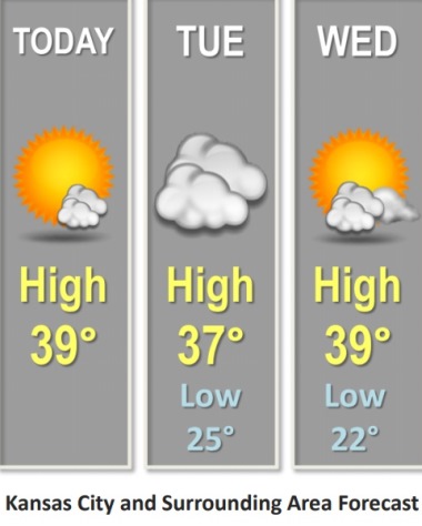
Cool weather is in the forecast Monday, as temperatures were 24 degrees at 9 a.m., and may rise to a high near 39, according to the National Weather Service.

On Tuesday evening, there is a slight chance for light snow or flurries over east central Kansas, the weather service said. However, it most likely will be south of Wyandotte County. Snow is not in the Wyandotte County forecast.

Temperatures will warm up to the mid-40s on Thursday, and could hit 50 on Friday, according to the weather service.

Today, it will be mostly sunny, with a high near 39 and a light and variable wind becoming east around 6 mph in the afternoon, the weather service said.

Tonight, it will be mostly cloudy, with a low around 25 and an east wind of 5 to 7 mph, according to the weather service.

Tuesday, it will be cloudy, with a high near 37 and an esat southeast wind of 9 mph, the weather service said.

Tuesday night, it will be cloudy, then gradually becoming partly cloudy, with a low of 22, according to the weather service. An east northeast wind of 5 to 8 mph will become calm in the evening.

Wednesday, it will be sunny with a high near 39 and a light and variable wind, the weather service said.

Wednesday night, it will be mostly clear, with a low around 24, according to the weather service.

Thursday, it will be sunny, with a high near 47, the weather service said.

Thursday night, it will be mostly cloudy, with a low of 33, according to the weather service.

Friday, it will be partly sunny, with a high near 50, the weather service said.

Friday night, it will be mostly cloudy, with a low of 31, according to the weather service.

Saturday, it will be mostly sunny, with a high near 46, the weather service said.

Saturday night, it will be mostly clear, with a low of 28, according to the weather service.

Sunday, it will be sunny, with a high near 52, the weather service said.

Rain in forecast tonight

Snow is possible to the north of Wyandotte County tonight and Saturday. Wyandotte County’s forecast calls for rain, although a slight change in temperatures could change this forecast. (National Weather Service forecast)

The weather forecast has changed, with rain only now in the forecast for Wyandotte County, according to the National Weather Service.

Snow and wintry precipitation is possible to the north of Wyandotte County, near St. Joseph, Missouri, where there could be 1 to 2 inches, according to weather service maps.

Wyandotte County may get a tenth of an inch of rain, the weather service said. The county saw some sprinkles this morning. Temperatures are not expected to drop below freezing until Saturday night, according to the forecast.

The low should be 33 tonight in Wyandotte County, according to the forecast, but if it dips below that, then some snow might be possible.

Today, there is a 50 percent chance of rain with a high near 45, and a north wind of 5 to 7 mph, the weather service said. Less than a tenth of an inch of rain is possible.

Tonight, there is a 50 percent chance of rain, with a low of 33 and a northwest wind of 6 to 10 mph, according to the weather service. Less than a tenth of an inch of rain is possible.

Saturday, the high will be near 37 with a north northwest wind of 9 to 13 mph, the weather service said.

Saturday night, it will be mostly cloudy, with a low of 27 and a north northwest wind of 5 to 8 mph, becoming calm in the evening, according to the weather service.

Sunday, it will be mostly cloudy, then gradually becoming sunny, with a high near 39 and a north northwest wind of 5 to 7 mph, the weather service said.

Sunday night, it will be mostly clear, with a low of 23, according to the weather service.

Monday, it will be mostly sunny, with a high near 44, the weather service said.

Monday night, it will be mostly cloudy, with a low of 28, according to the weather service.

Tuesday, it will be mostly cloudy, with a high near 39, the weather service said.

Tuesday night, it will be mostly cloudy, with a low of 22, according to the weather service.

Wednesday, it will be mostly sunny, with a high near 40, the weather service said.

Wednesday night, it will be partly cloudy, with a low of 26, according to the weather service.

Thursday, it will be mostly sunny, with a high near 44, the weather service said.

Today’s high in mid-60s

National Weather Service graphic

Today’s high will be in the mid-60s, according to the National Weather Service.

Quiet weather continues today, with rain chances moving in from Thursday night to Friday, the weather service said.

Temperatures will fall sharply on Friday, with highs in the low 40s, according to the weather service.

There is a chance for rain and snow on Friday night and Saturday, the weather service said.

Today, it will be sunny, with a high near 65 and a northwest wind of 5 to 7 mph becoming light and variable in the afternoon, the weather service said.

Tonight, it will be clear, wth a low of 36 and a calm wind, according to the weather service.

Thursday, it will be sunny with a high near 63 and a light and variable wind, the weather service said.

Thursday night, there is a 20 percent chance of rain after midnight, with increasing clouds, and a low of 37, according to the weather service.

Friday, there is a 60 percent chance of rain, with a high near 42 and a north northeast wind of 6 to 10 mph, the weather service said. Between a quarter and half-inch of rain is possible.

Friday night, there is a 50 percent chance of rain before 1 a.m., then a chance of rain and snow, according to the weather service. The low will be around 33. Between a tenth and quarter-inch of snow is possible.

Saturday, there is a 30 percent chance of rain before 7 a.m., then a chance of snow between 7 a.m. and noon, the weather service said. The high will be 38.

Saturday night, it will be mostly cloudy, with a low of 25, according to the weather service.

Sunday, it will be mostly sunny, with a high near 37, the weather service said.