Winter storm watch issued for New Year’s Eve

National Weather Service graphic

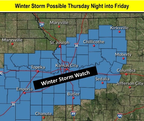
A winter storm watch will take effect for 9 p.m. Dec. 31 through 6 p.m. Jan. 1, according to the National Weather Service.

Freezing rain, snow and sleet may hit the area on New Year’s Eve, followed by more of the same plus snow on New Year’s Day, the weather service said.

From 1 to 3 inches of snow and up to three-tenths of an inch of ice is possible, according to the weather service.

Travel may become hazardous on New Year’s Eve and New Year’s Day because of icy and snowy roads, the weather service said.

Wednesday morning, area highways were slick in spots, with several accidents reported near I-635 and K-5 and also on I-435 near Leavenworth Road, according to KC Scout. The temperature was 33 degrees at 9 a.m.

Today, it will be partly sunny, with a high near 35 and a north northwest wind of 7 to 10 mph, the weather service said.

Tonight, it will be partly cloudy, with a low of 19 and a north northwest wind of 6 mph becoming calm in the evening, according to the weather service.

Thursday, it will be mostly sunny, with a high near 37 and a calm wind becoming northeast 5 to 9 mph in the morning, the weather service said.

Thursday night, New Year’s Eve, there is an 80 percent chance of snow and sleet before 1 a.m., then snow, freezing rain and sleet between 1 a.m. and 3 a.m., then freezing rain and sleet after 3 a.m., according to the weather service. The low will be around 26 with an east northeast wind of 8 to 14 mph, gusting as high as 24 mph. New ice accumulation of around a tenth of an inch is possible. New snow and sleet accumulation of around an inch is possible.

Friday, New Year’s Day, there is a 90 percent chance of snow, freezing rain and sleet before 8 a.m., then snow and freezing rain between 8 a.m. and 10 a.m., then snow after 10 a.m., the weather service said. The high will be near 33 with a north northeast wind of 11 to 14 mph, gusting as high as 25 mph. New snow and sleet accumulation could be 1 to 3 inches.

Friday night, it will be mostly cloudy, with a low of about 20, according to the weather service.

Saturday, it will be partly sunny, with a high near 33, the weather service said.

Saturday night, it will be mostly clear, with a low of 16, according to the weather service.

Sunday, it will be sunny, with a high near 41, the weather service said.

Sunday night, it will be partly cloudy, with a low of 26, according to the weather service.

Monday, it will be mostly sunny, with a high near 45, the weather service said.

Monday night, it will be mostly cloudy, with a low of 27, according to the weather service.

Tuesday, it will be partly sunny, with a high near 44, the weather service said.

Arctic blast hits Wyandotte County

National Weather Service graphic
Bitterly cold wind chills were reported Thursday morning. (National Weather Service graphic)
There is a 50 to 70 percent chance of rain, snow and ice on Tuesday, and 50 percent chance of rain, snow and ice on Wednesday. (National Weather Service graphic)

Temperatures were bitterly cold Thursday morning. It was 16 degrees at 9 a.m., with a wind chill of 3, according to the National Weather Service.

Today’s high will reach only 27 degrees, the weather service said.

An arctic airmass behind the strong cold front on Wednesday has started to build into the region and is currently over the northern portion of the state, according to the weather service.

Winds are adding to the cold feeling, with wind gusts up to 25 mph possible today, the weather service said.

Tonight, Christmas Eve, the low will be 13, according to the weather service. It will warm up a little on Friday. Lows could be in the teens on Christmas morning, gradually increasing to about 40, but it will not be as windy.

No snow or ice is in the forecast for Christmas. But snow and ice is in the forecast for Monday night through Wednesday.

Today, it will be sunny with a high near 27 and a northwest wind of 11 to 16 mph, gusting to 25 mph, the weather service said.

Tonight, Christmas Eve, if will be clear, with a low of 13 and a north northwest wind of 6 to 10 mph, gusting as high as 21 mph, according to the weather service.

Friday, Christmas Day, it will be sunny, with a high near 40 and a west northwest wind of 5 to 11 mph, becoming south southwest in the afternoon, the weather service said.

Friday night, it will be clear, with a low of 28 and a southwest wind of 5 to 8 mph, according to the weather service.

Saturday, it will be mostly sunny, with a high near 55 and a south wind of 5 to 8 mph, the weather service said.

Saturday night, it will be partly cloudy, with a low of 36, according to the weather service.

Sunday, it will be mostly sunny, with a high near 49, the weather service said.

Sunday night, it will be partly cloudy, with a low of 21, according to the weather service.

Monday, it will be mostly sunny, with a high near 34, the weather service said.

Monday night, there is a 30 percent chance of snow after midnight, with a low of 22, according to the weather service.

Tuesday, there is a 70 percent chance of rain and snow, possibly mixed with freezing rain and sleet, the weather service said. The high will be near 36.

Tuesday night, there is a 70 percent chance of rain and snow, possibly mixed with freezing rain, according to the weather service. The low will be around 27.

Wednesday, there is a 50 percent chance of rain and snow, with a high near 38, the weather service said.

Temperatures to slide down to 31 by 5 p.m. today

National Weather Service graphic

A strong cold front will move through the area this morning, with wind gusts of up 40 mph, according to the National Weather Service.

A wind advisory is in effect until 6 p.m. today.

The temperature was 47 at 9 a.m. Wednesday, and will fall during the day, reaching about 31 degrees by 5 p.m., the weather service said.

Tonight’s low will drop to about 17, while Thursday’s high will be near 26, according to the weather service.

The Christmas Eve forecast, Thursday night, will be a low of 13. Christmas Day, temperatures will reach a high of about 41, the weather service said.

Today, it will be mostly cloudy, with temperatures falling to around 31 by 5 p.m., the weather service said. A west northwest wind will be 20 to 24 mph, gusting as high as 40 mph.

Tonight, it will be mostly cloudy, then gradually becoming mostly clear, with a low of 17, according to the weather service. A northwest wind of 14 to 21 mph will gust as high as 38 mph.

Thursday, it will be sunny, with a high near 26, the weather service said. A northwest wind will be 13 to 18 mph, gusting as high as 30 mph.

Thursday night, it will be clear, with a low of 13 and a north northwest wind of 5 to 10 mph, gusting as high as 18 mph, according to the weather service.

On Friday, Christmas Day, it will be sunny, with a high near 41 and a west northwest wind of 5 to 9 mph, becoming southwest in the afternoon, the weather service said.

Friday night, it will be mostly clear, with a low of 27, according to the weather service.

Saturday, it will be mostly sunny, with a high near 51, the weather service said.

Saturday night, it will be mostly cloudy, with a low of 36, according to the weather service.

Sunday, it will be partly sunny, with a high near 49, the weather service said.

Sunday night, it will be partly cloudy, with a low of 21, according to the weather service.

Monday, it will be sunny, with a high near 35, the weather service said.

Monday night, it will be partly cloudy, with a low of 21, according to the weather service.

Tuesday, there will be a 30 percent chance of rain and snow, with a high near 37, the weather service said.