Winter weather advisory issued for tonight
Serving Kansas City (Wyandotte County) Kansas for over 50 years!
Snow, rain, freezing rain and sleet are possible on Monday, according to the forecast from the National Weather Service.
While the track of the storm is still uncertain, there is an 80 percent chance of precipitation on Monday, the weather service said.
Saturday night and Sunday, there will be a chance of light rain, making the transition to freezing rain on Sunday night, according to the forecast.
The forecast for Friday is much cooler, with northeasterly winds around 8 mph, the weather service said.
On the weekend, there will be daytime winds from 9 to 13 mph, with a chance of light rain, according to the weather service..
Today, it will be mostly sunny, with a high near 36 and a north northeast wind of 8 mph, the weather service said.
Tonight, it will be mostly clear, with a low of 22 and an east wind of 7 mph, according to the weather service.
Saturday, it will be partly sunny, with a high near 41 and a southeast wind of 8 to 13 mph, gusting as high as 18 mph, the weather service said.
Saturday night, there is a 30 percent chance of rain after midnight, with a low of 34, according to the weather service, and a south wind of 6 to 8 mph. Less than a tenth of an inch of precipitation is possible.
Sunday, there is a 30 percent chance of rain before noon with a high near 44, the weather service said. A south southeast wind of 5 to 8 mph will become north northeast in the afternoon. Less than a tenth of an inch of rain is possible.
Sunday night, there is a 50 percent chance of rain possible before 3 a.m., then a chance of rain or freezing rain between 3 a.m. and 5 a.m., then a chance of snow, freezing rain and sleet after 5 a.m., according to the weather service. The low will be around 30. Between a tenth and quarter-inch of precipitation is possible.
Monday, there is an 80 percent chance of snow, possibly mixed with freezing rain and sleet, before 10 a.m., then snow between 10 a.m. and 5 p.m., then a chance of snow and freezing rain after 5 p.m., the weather service said. The high will be near 35.
Monday night, it will be mostly cloudy, with a low of 23, according to the weather service.
Tuesday, it will be mostly cloudy, with a high near 36, the weather service said.
Tuesday night, it will be mostly cloudy, with a low of 28, according to the weather service.
Wednesday, there is a 30 percent chance of rain, with a high near 41, the weather service said.
Wednesday night, it will be mostly cloudy, with a low of 25, according to the weather service.
Thursday, it will be mostly sunny, with a high near 43, the weather service said.
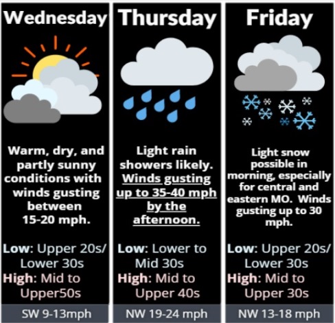
Mild, windy weather is in the forecast for Wednesday, according to the National Weather Service.
Today’s high will be near 57 with sunny skies and winds gusting as high as 21 mph, the weather service said.
Thursday, winds will increase as rain returns to the area, according to the weather service.
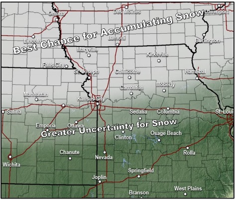
Light snow is possible overnight Thursday into Friday morning, the weather service said. A light dusting is possible. Snow showers Friday morning could affect the commute.
Today, it will be partly sunny, then gradually becoming sunny, with a high near 57 and a south southwest wind of 7 to 11 mph, gusting as high as 21 mph, the weather service said.
Tonight, there will be increasing clouds, with a low of 37, according to the weather service. A southwest wind of 6 to 14 mph will become northwest after midnight, with winds gusting as high as 29 mph.
Thursday, there is a 30 percent chance of rain before noon, with a high near 48, the weather service said. A northwest wind of 15 to 22 mph will gust as high as 38 mph. Less than a tenth of an inch of rain is possible.
Thursday night, it will be mostly cloudy, with a low of 30 and a west northwest wind of 13 to 15 mph, gusting as high as 22 mph, according to the weather service.
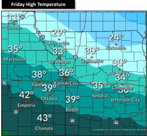
Friday, there is a 20 percent chance of snow showers, with a high near 37, the weather service said. A northwest wind of 15 to 18 mph will gust as high as 32 mph.
Friday night, it will be mostly cloudy, with a low of 25, according to the weather service.
Saturday, it will be partly sunny, with a high near 38, the weather service said.
Saturday night, it will be mostly cloudy, with a low of 25, according to the weather service.
Sunday, it will be mostly sunny, with a high near 41, the weather service said.
Sunday night, it will be partly cloudy, with a low of 25, according to the weather service.
Monday, Martin Luther King Jr. Day, it will be sunny, with a high near 46, the weather service said.
Monday night, it will be mostly cloudy, with a low of 27, according to the weather service.
Tuesday, it will be mostly sunny, with a high near 44, the weather service said.