Warming trend today in Wyandotte County

Winds from the south may gust up to 22 mph on Friday in Wyandotte County, up to 23 mph on Saturday, and up to 28 mph on Sunday, according to the forecast. (National Weather Service graphic)
Rain on Saturday will be widespread in the region. Up to 1 inch is possible in Wyandotte County. (National Weather Service graphic)

Look for temperatures to rise to the mid-40s today in Wyandotte County, according to the National Weather Service.

While there was still snow on the ground at 9 a.m. Friday, when temperatures were at 35 degrees, the snow might continue melting during the rest of the day.

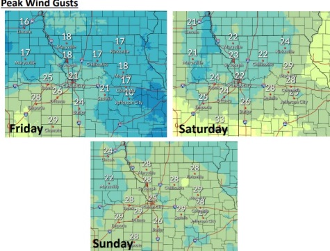
Friday is Kansas Day, and the term Kansas derives from “people of the south wind.” The south wind plays a role in today’s weather forecast, with wind gusts of up to 22 mph today from the south.

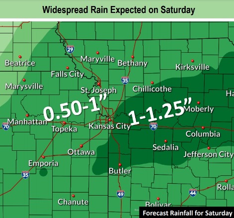
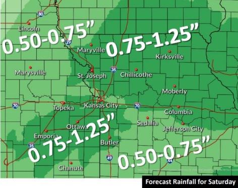
Widespread rain is expected on Saturday, the weather service said, and between three-quarters and one inch of rain is possible. Temperatures will rise to 48 on Saturday.

Minor flooding may be possible Saturday on some creeks and streams, according to the weather service.

Today, it will be mostly sunny, with a high near 46 and a south wind of 9 to 11 mph, gusting as high as 22 mph, the weather service said.

Tonight, it will be mostly cloudy, with a low of 40 and a southeast wind of 9 to 3 mph, gusting to 20 mph, according to the weather service.

Saturday, there is a 90 percent chance of rain, with thunderstorms also possible after noon, the weather service said. The high will be near 48 with a southeast wind of 7 to 13 mph, gusting as high as 23 mph. Between three-quarters and an inch of rain is possible.

Saturday night, there is a 40 percent chance of rain before midnight, with a low of 32, according to the weather service. A northwest wind of 5 to 10 mph will increase to 11 to 16 mph after midnight, with winds gusting as high as 23 mph. Less than a tenth of an inch of precipitation is possible.

Sunday, it will be mostly cloudy, with a high near 37 and a north northwest wind of 14 to 17 mph, gusting as high as 28 mph, the weather service said.

Sunday night, it will be mostly cloudy, with a low of 25, according to the weather service.

Monday, it will be sunny, with a high near 43, the weather service said.

Monday night, it will be partly cloudy, with a low of 28, according to the weather service.

Tuesday, it will be mostly sunny, with a high near 51, the weather service said.

Tuesday night, it will be mostly cloudy, with a low of 37, according to the weather service.

Wednesday, it will be mostly cloudy, with a high near 55, the weather service said.

Wednesday night, there is a 30 percent chance of rain, with a low of 32, according to the weather service.

Thursday, there is a 40 percent chance of rain, with a high near 42, the weather service said.

After cold start, today warms up to 37

Rain is in the forecast for Saturday, according to the National Weather Service. (National Weather Service graphic)

The wind chill was 18 degrees at 8 a.m. Thursday, and temperatures will warm up to a high of 37, according to the National Weather Service forecast.

Friday and Saturday, look for temperatures to rocket to the 40s and 50s, the weather service said.

Rain moves into the forecast on Saturday, with three-quarters to an inch of rain in the forecast here. At this time, it appears that temperatures on Saturday will be above freezing, but on Saturday night, the temperature could be as low as 32.

Temperatures will decline after the rain, with a high of 38 possible on Sunday, the weather service said.

From Monday through Wednesday, look for daytime highs in the 40s and 50s, according to the weather service.

Today, it will be mostly cloudy, then gradually sunny, with a high near 37 and a light southeast wind becoming south southeast 5 to 10 mph in the morning, the weather service said.

Tonight, it will be partly cloudy, with a low of 29 and a south wind of 6 to 8 mph, according to the weather service.

Friday, it will be sunny with a high near 49 and a south wind of 8 to 14 mph, gusting as high as 23 mph, the weather service said.

Friday night, it will be partly cloudy, with a low of 38 and a south southeast wind of 8 to 13 mph, according to the weather service.

Saturday, there is an 80 percent chance of precipitation, with rain expected before noon, then showers and possibly a thunderstorm after noon, the weather service said. The high will be near 50 with a south southeast wind of 9 to 13 mph becoming north in the afternoon. Winds may gust as high as 18 mph. From three-quarters to an inch of rain is possible.

Saturday night, there is a 30 percent chance of rain before midnight, with a low of 32, according to the weather service. Less than a tenth of an inch of rain is possible.

Sunday, it will be mostly cloudy, with a high near 38, the weather service said.

Sunday night, it will be mostly cloudy, with a low of 26, according to the weather service.

Monday, it will be sunny, with a high near 45, the weather service said.

Monday night, it will be mostly clear, with a low of 27, according to the weather service.

Tuesday, it will be mostly sunny, with a high near 49, the weather service said.

Tuesday night, it will be mostly cloudy, with a low of 35, according to the weather service.

Wednesday, it will be partly sunny, with a high near 52, the weather service said.

Storm leaves an inch or two of snow on ground

An accident was reported Wednesday morning near I-635, near Metropolitan. (KC Scout photo)
Another accident was on I-635 near Swartz Road on Wednesday morning. (KC Scout photo)
Another accident was at I-635 near K-5 on Wednesday morning, according to KC Scout. (KC Scout photo)

An overnight storm has left an inch or two of snow on the ground on Wednesday morning.

Several accidents were reported Wednesday morning on area highways. Motorists are advised to be careful of slick spots on the roads today, as the high will reach only 27.

But snow won’t be on the ground too long, as temperatures will rise to 37 on Thursday and 50 on Friday, according to the National Weather Service forecast. Gusty winds are possible on Saturday.

The next chance of precipitation was expected Saturday, when there will be rain and warmer temperatures, according to the weather service.

Today, it will be cloudy, with a high near 27 and a north wind of 6 to 8 mph, the weather service said.

Tonight, it will be mostly cloudy, with a low of 20 and a north wind of 6 mph becoming light and variable, according to the weather service.

Thursday, it will be mostly sunny, with a high near 37 and a south wind of 5 to 10 mph, the weather service said.

Thursday night, it will be partly cloudy, with a low of 30 and a south wind of 6 to 9 mph, according to the weather service.

Friday, it will be mostly sunny, with a high near 50 and a south wind of 8 to 13 mph, the weather service said.

Friday night, there is a 20 percent chance of rain after midnight, with a low of 39, according to the weather service.

Saturday, there is an 80 percent chance of rain with a high near 49, the weather service said.

Saturday night, there is a 30 percent chance of rain before midnight, with a low of 32, according to the weather service.

Sunday, it will be mostly cloudy, with a high near 40, the weather service said.

Sunday night, it will be mostly cloudy, with a low of 27, according to the weather service.

Monday, it will be mostly sunny, with a high near 46, the weather service said.

Monday night, it will be partly cloudy, with a low of 28, according to the weather service.

Tuesday, it will be mostly sunny, with a high near 49, the weather service said.

For more information on the weather, visit www.weather.gov.

Check highway conditions at http://www.kcscout.net/.