Snow arrives in Wyandotte County

One to two inches of snow is in the forecast for Wyandotte County. Areas to the north may experience heavier snow. (National Weather Service graphic)
An accident was reported near I-435 and Kansas Avenue at 1:35 p.m. Saturday, according to KC Scout. (KC Scout photo)
An accident was reported at 1:19 p.m. Saturday at I-635 near Parallel Parkway, according to KC Scout. (KC Scout photo)
An accident was reported at 1:38 p.m. on northbound I-35 near Mission Road. (KC Scout photo)

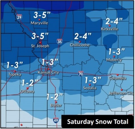
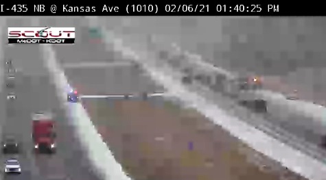
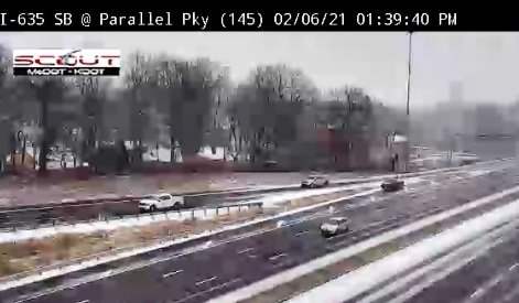
Light and dry snow was falling at 1 p.m. Saturday in Wyandotte County.

Wyandotte County is under a winter weather advisory until 9 p.m. Saturday, according to the National Weather Service. Motorists are advised to be very careful.

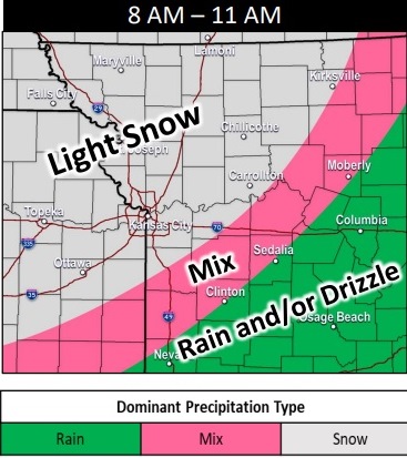
Light snow is expected over a wide area, from Kansas City to Manhattan, Kansas. The snow is moving from the northwest and was expected to persist through the day, exiting overnight, the weather service said.

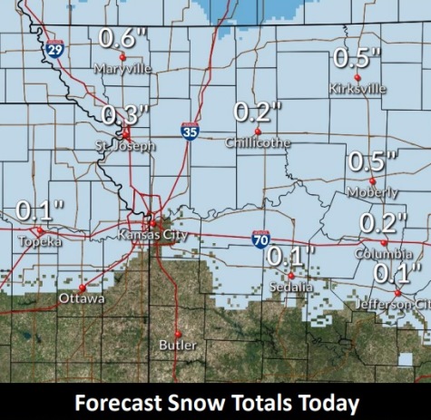
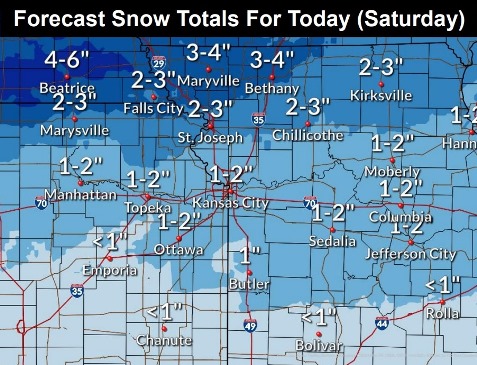
Several rounds of light snow are possible Sunday and Monday, as well. Additional accumulations of 1 to 2 inches are expected north of the Missouri River, with areas to the south of the river receiving an additional inch.

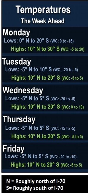
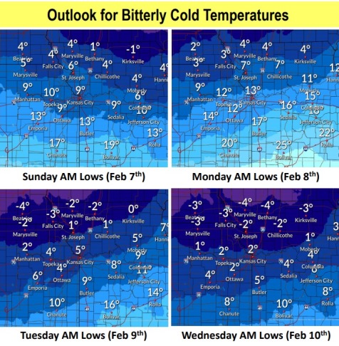
Bitterly cold temperatures will continue through the entire week, and beyond, with wind chill values frequently going well below zero each morning, according to the weather service. At times, wind chills could reach double digits below zero.

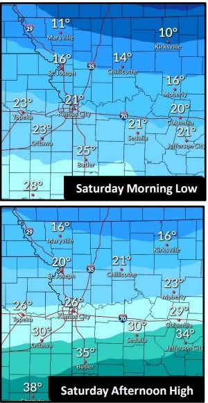
This afternoon, snow is in the forecast mainly before 3 p.m. in Wyandotte County, the weather service said. Temperatures will fall to around 17 by 5 p.m. A north northeast wind of 10 to 13 mph will gust as high as 18 mph. Total daytime snow accumulation of 1 to 3 inches is possible.

Tonight, it will be mostly cloudy, with a low of 8, according to the weather service. Wind chill values between minus 4 and 4 are possible. The north wind will be 6 to 10 mph.

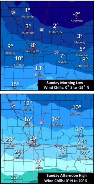
Sunday, there is a 20 percent chance of snow before 9 a.m., then a slight chance of snow after noon, the weather service said. The high will be near 19 with wind chill values between minus 4 and 6. There will be an east wind of 7 to 10 mph.

Sunday night, there will be a 20 percent chance of snow after midnight, with a low of 12 and a northeast wind of 6 to 9 mph, according to the weather service.

Monday, there is a 30 percent chance of snow, mainly before noon, the weather service said. The high will be near 20 with a northeast wind of 10 mph.

Monday night, it will be mostly cloudy, with a low of 3, according to the weather service.

Tuesday, it will be mostly cloudy, with a high near 17, the weather service said.

Tuesday night, it will be mostly cloudy, with a low around 6, according to the weather service.

Wednesday, it will be cloudy, with a high near 18, the weather service said.

Wednesday night, it will be mostly cloudy, with a low around 6, according to the weather service.

Thursday, it will be mostly cloudy and cold, with a high near 14, the weather service said.

Thursday night, it will be mostly cloudy, with a low of 1, according to the weather service.

Friday, it will be mostly cloudy and cold, with a high near 11, the weather service said.

For more weather information, visit www.weather.gov.

Snow in forecast for Saturday

Blast of cold air to last through mid-February

Snow is in the forecast for Saturday. (National Weather Service graphic)
Saturday temperatures in the area will be in the 20s and mid-20s. (National Weather Service graphic)
The low will be 8 degrees Sunday morning, and the high will be about 21. (National Weather Service graphic)
Sub-freezing temperatures are in next week’s forecast and could last until mid-February. (National Weather Service graphic)

Snow will be in the forecast for Saturday, according to the National Weather Service.

Light snow will move in from the west to the east, and last through late morning or early afternoon, the weather services said. There could be four to six hours of snow.

Wyandotte County could receive 2 to 4 inches of snow Saturday, according to the forecast. Snow could be moderate to heavy at times.

A stretch of sub-freezing temperatures is expected to last through the weekend and next week, the weather service said. This will be a significant stretch of sub-freezing temperatures, that may last into the middle part of February. It could last beyond mid-February, also, according to the weather service.

There will be chances of off and on snow through next week, but at this time none of these rounds of snow appear to have high impact accumulation, according to the weather service.

Today, it will be partly sunny with a high near 42 and a northwest wind of 5 to 9 mph, the weather service said.

Tonight, there will be increasing clouds, with a low of 21 and a north wind of 5 to 8 mph becoming east after midnight, according to the weather service.

Saturday, there is a 60 percent chance of snow with a high near 26, the weather service said. An east wind of 8 to 13 mph will become north in the afternoon, and winds may gust up to 20 mph. New snow accumulation of 2 to 4 inches is possible.

Saturday night, it will be mostly cloudy, with a low of 8, according to the weather service, and wind chill values of between minus 2 to 3. There will be a north northeast wind of 7 to 9 mph.

Sunday, it will be cloudy, with a high near 21 and an east wind of 8 to 10 mph, the weather service said.

Sunday night, it will be mostly cloudy, with a low of 11, according to the weather service.

Monday, there is a 30 percent chance of snow with a high near 21, the weather service said.

Monday night, it will be mostly cloudy, with a low of 3, according to the weather service.

Tuesday, it will be partly sunny and cold, with a high near 14, the weather service said.

Tuesday night, it will be mostly cloudy, with a low of 2, according to the weather service.

Wednesday, it will be partly sunny, with a high near 16, the weather service said.

Wednesday night, it will be mostly cloudy, with a low of 3, according to the weather service.

Thursday, it will be mostly cloudy and cold, with a high near 15, the weather service said.

For more weather information, visit www.weather.gov.

Snowstorm arrives in Wyandotte County

Snowstorm moves into Wyandotte County on Thursday morning.

Wyandotte County may get a half-inch of snow this morning. (National Weather Service graphic)
Light snow was falling on Thursday morning in Wyandotte County. (National Weather Service graphic)
Expect bitterly cold temperatures through teh weekend and into next week. (National Weather Service graphic)

A snowstorm arrived in Wyandotte County about 8:45 a.m. Thursday.

Less than a half-inch of snow is predicted with this storm, according to the National Weather Service forecast.

Colder air has moved into the area, creating strong winds and falling temperatures through the day, the weather service said. The temperature was 34 degrees at 9 a.m. Temperatures will fall to 32 by 5 p.m., according to the forecast.

An extended period of bitterly cold temperatures, including the coldest air of the winter season so far, is expected by this weekend into next week, according to the weather service.

In addition, wind chil values will be minus 5 to minus 15 degrees on Sunday morning, the weather service said.

Another chance for a couple of rounds of light snow will occur Saturday and again Monday, with minor accumulations possible, according to the weather service.

Today, it was snowing at 9 a.m. and snow may continue through noon, the weather service said. Skies will gradually clear, and temperatures will fall to around 32 by 5 p.m. It will be breezy, with a northwest wind of 16 to 23 mph, gusting to 39 mph. Daytime snow accumulation should be less than a half-inch.

Tonight, it will be mostly clear, with a low of 27 and a west wind of 6 to 14 mph, gusting as high as 25 mph, according to the weather service.

Friday, it will be mostly sunny, with a high near 43 and a west wind of 6 to 10 mph becoming north northwest in the afternoon, the weather service said.

Friday night, it will be partly cloudy, with a low of 21 and a north wind of 6 mph becoming calm in the evening, according to the weather service.

Saturday, there is a 50 percent chance of snow before 3 p.m., then a chance of rain and snow, the weather service said. It will be partly sunny, with a high near 34 and a light and variable wind becoming west 6 to 11 mph in the morning. Winds may gust as high as 21 mph. Less than a tenth of an inch of precipitation is possible.

Saturday night, it will be mostly cloudy, with a low of 9, according to the weather service.

Sunday, it will be partly sunny with a high near 26, the weather service said.

Sunday night, it will be mostly cloudy, with a low of 12, according to the weather service.

Monday, there is a 30 percent chance of snow, with a high near 20, the weather service said.

Monday night, it will be mostly cloudy, with a low of 4, according to the weather service.

Tuesday, it will be mostly cloudy, with a high near 17, the weather service said.

Tuesday night, it will be mostly cloudy, with a low of 1, according to the weather service.

Wednesday, it will be mostly sunny, with a high of 20, the weather service said.

For more weather information, visit www.weather.gov.