Dangerous cold in forecast, light snow possible Friday afternoon

The wind chill was minus 2 at 9 a.m. Thursday in Wyandotte County, according to the National Weather Service. At 7 a.m. Thursday, the wind chill was minus 8. (National Weather Service graphic)
Light snow is in the forecast for Friday afternoon. (National Weather Service graphic)
On Saturday morning, the wind chill could drop to minus 12. (National Weather Service graphic)
On Sunday morning, the wind chill could be minus 19. (National Weather Service graphic)

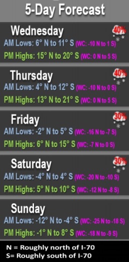
Below freezing temperatures and wind chills continue today, with a slight chance of snow on Friday afternoon, according to the National Weather Service.

Temperatures will be falling through the weekend, and overnight wind chills could be between minus 10 and minus 20 degrees, the weather service said. Those who are providing or using warming shelters should start making plans now.

The next round of snow will arrive Friday afternoon and will continue overnight into Saturday morning, according to the weather service.

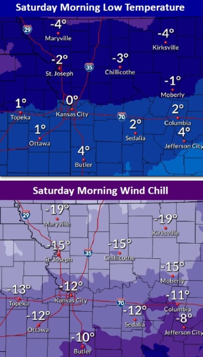
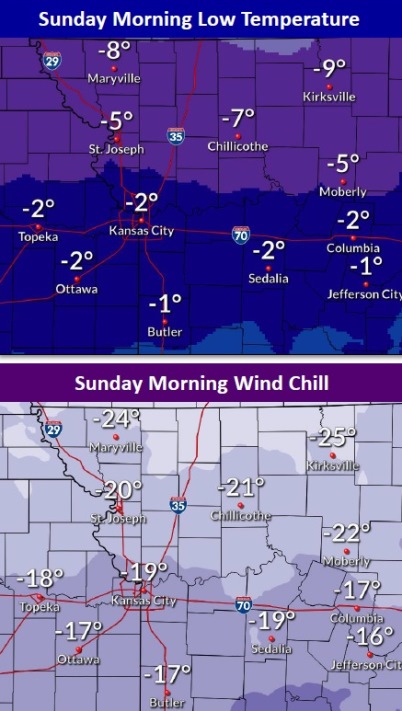
The coldest and most dangerous conditions are expected Saturday, Sunday and Monday mornings with wind chills near minus 20 F, the weather service said.

Dangerously cold temperatures and wind chills expected this weekend and early next week, according to the weather service. Temperatures remain below freezing through next week.

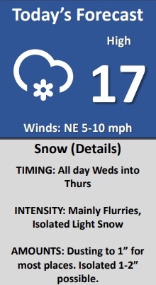
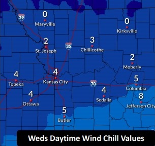
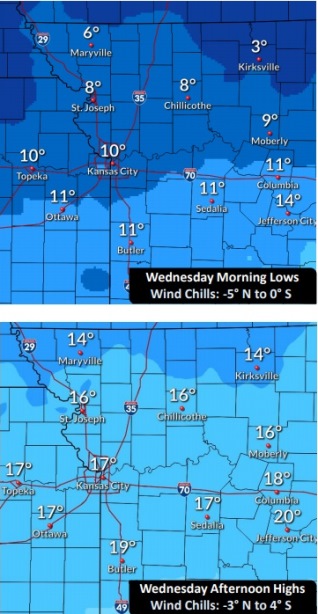
Today, it will be cloudy with a high near 17, and wind chill values between minus 4 and 3, the weather service said.A north northeast wind will be around 11 mph.

Tonight, it will be mostly cloudy, with a low of 3 and wind chill values between minus 1 and minus 11, according to the weather service. There will be a north wind of around 11 mph.

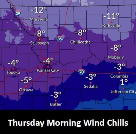
Friday, it will be cloudy and cold, with a high near 11 and wind chill values between minus 5 and minus 12, the weather service said. A north northeast wind will be 10 to 13 mph.

Friday night, there is a 20 percent chance of snow, with a low of 1, and wind chill values between minus 8 and minus 13, according to the weather service. A north northeast wind of 9 to 13 mph is forecast.

Saturday, it will be partly sunny and cold, with a high near 10 and a north wind of 10 mph, the weather service said.

Saturday night, it will be mostly cloudy, with a low of minus 2, according to the weather service.

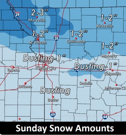
Sunday, there will be a 30 percent chance of snow, with a high near 3, the weather service said.

Sunday night, there is a 40 percent chance of snow, with a low of minus 8, according to the weather service.

On Monday, Washington’s Birthday, there is a 30 percent chance of snow after noon, with a high near 4, the weather service said.

Monday night, there is a 30 percent chance of snow before midnight, with a low of minus 8, according to the weather service.

Tuesday, it will be partly sunny and cold, with a high near 13, the weather service said.

Tuesday night, it will be mostly cloudy with a low of 3, according to the weather service.

Wednesday, it will be mostly cloudy, with a high near 22, the weather service said.

For more weather information, visit www.weather.gov.

Snow, bitter cold in today’s forecast

Wyandotte County could see some light snow flurries today. (National Weather Service graphic)
National Weather Service graphic
Wednesday’s wind chill is in the single digits. At 9 a.m. Wednesday, the wind chill was zero in Wyandotte County. (National Weather Service graphic)
The high this afternoon could rise to 17. (National Weather Service graphic)
The weather turns even colder on the weekend. (National Weather Service graphic)

Light flurries are in the forecast for Wednesday, mainly before 4 p.m., according to the National Weather Service.

The heaviest snow is expected to be around I-70, the weather service said.

Slippery roads and sidewalks are expected, and residents are asked to exercise caution if traveling, according to the weather service. At 9 a.m., it was clear in Wyandotte County, with no snow on the highways, with a slight possibility of snow later in the day. Some of the side streets were snow-covered from a previous storm.

The prolonged stretch of sub-freezing temperatures will continue during the next several days, with bitterly cold temperatures and dangerous wind chills expected.

Today, there is a 30 percent chance of snow, mainly before 4 p.m., with a high near 17, the weather service said. The wind chill will be between minus 1 and 4. A north northeast wind of 8 to 10 mph is possible.

Tonight, there is a 20 percent chance of snow before midnight, then a slight chance of snow after 3 a.m., according to the weather service. The low will be around 10 with wind chill values between minus 3 and 4. A northeast wind will be around 10 mph.

Thursday, it will be cloudy, with a high near 17 and wind chill values between minus 3 and 3, and a northeast wind of 11 mph, the weather service said.

Thursday night, it will be mostly cloudy, with a low of 2 and wind chill values between minus 4 and minus 9, and a north northeast wind of 7 to 10 mph, according to the weather service.

Friday, there is a 20 percent chance of snow after noon, with a high near 12 and a north northeast wind of 8 to 11 mph, the weather service said.

Friday night, there is a 40 percent chance of snow, with a low around 0, according to the weather service.

Saturday, there is a 30 percent chance of snow before noon, with a high near 7, the weather service said.

Saturday night, it will be mostly cloudy, with a low of minus 6, according to the weather service.

Sunday, it will be partly sunny and cold, with a high near 5, the weather service said.

Sunday night, there is a 30 percent chance of snow after midnight, with a low of minus 5, according to the weather service.

Monday, Washington’s Birthday, there is a 30 percent chance of snow, with a high near 7, the weather service said.

Monday night, it will be mostly cloudy, with a low around minus 5, according to the weather service.

Tuesday, it will be partly sunny with a high near 17, the weather service said.

Snow, bitter cold on Sunday

An accident was reported at 12:02 p.m. Sunday, Feb. 7, on eastbound I-670 near the 7th Street Trafficway, according to KC Scout. (KC Scout photo)
It was snowing at midday Sunday in Wyandotte County. (National Weather Service graphic)

Snow and bitter cold weather have descended on Wyandotte County on Sunday, Feb. 7.

The snow may last through the afternoon and evening, moving from west to east, according to the National Weather Service.

Motorists should slow down on streets and highways, which could contain slick spots.

The wind chill at noon Sunday was minus 8, and the temperature was 6 degrees, according to the weather service.

There will be another chance for light snow with 1 to 2 inch accumulation Monday across far northern Missouri, mainly north of Highway 36.

The stretch of sub-freezing temperatures is expected to last through the week, into next weekend. This will be a significant stretch of sub-freezing temperatures that may last into the middle part of February.

Today, the high will be near 16, and an east wind will be about 9 mph. Less than one inch of snow is expected.

Tonight, there is a 20 percent chance of snow before 9 p.m., then a slight chance of snow after midnight, according to the weather service. The low will be around 9, with a northeast wind of 7 to 9 mph.

Monday, there is a 40 percent chance of snow, mainly before noon, with a high near 18 and a wind chill of minus 1 to 7, the weather service said.

Monday night, the low will be around 6 with a wind chill between minus 2 and 3, with a north northeast wind of 8 mph, according to the weather service.

Tuesday’s high will be about 20, with a northeast wind of 7 to 9 mph.