Showers, thunderstorms possible today

Wyandotte County is in an area that could have thunderstorms today. (National Weather Service graphic)

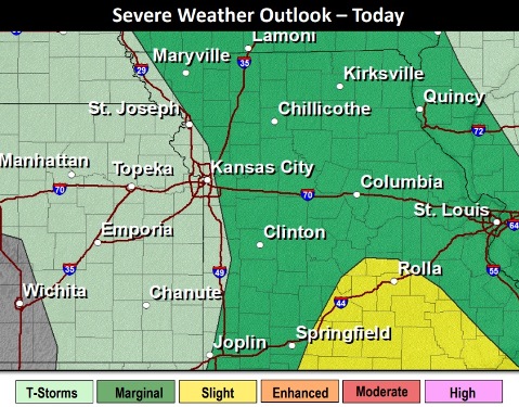
Showers and thunderstorms are possible today, with a high near 65, according to the National Weather Service.

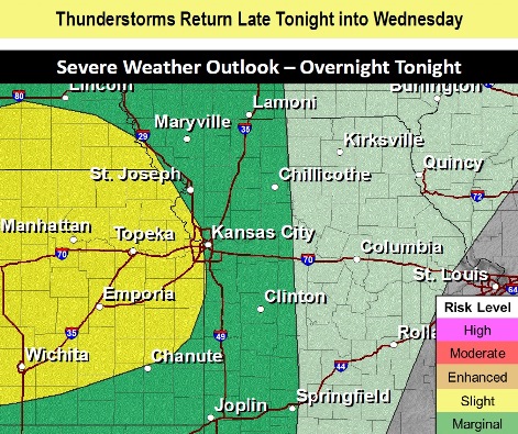
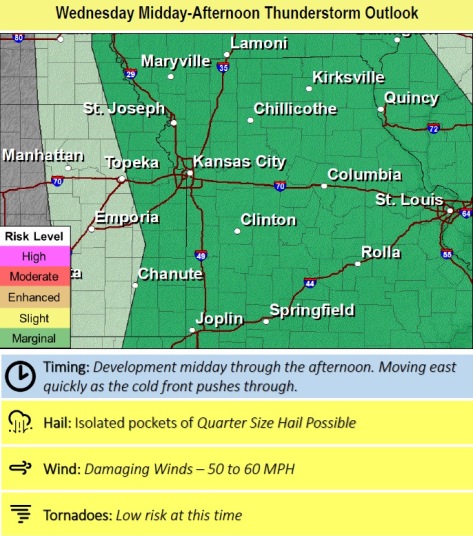
Storms may return around midday Wednesday, and some of the storms in the region could have large hail and strong winds, the weather service said.

After rain last night, rain chances are expected to continue through Thursday, with another chance for rain by Friday morning, according to the weather service.

Today, there is a 70 percent chance of showers and a thunderstorm before 1 p.m., then a chance of showers, the weather service said. The high will be near 65 with a southeast wind of 10 to 14 mph becoming southwest in the afternoon. Winds may gust as high as 24 mph. Between a tenth and quarter-inch of rain is possible.

Tonight, there is a 40 percent chance of showers before 7 p.m., then a chance of showers and thunderstorms after 10 p.m. , according to the weather service. The low will be around 46 with a southwest wind of 8 to 14 mph, gusting as high as 24 mph. Less than a tenth of an inch of rain is expected.

Thursday, there is a 50 percent chance of showers and possibly a thunderstorm. The high will be near 56 with a west wind of 9 to 15 mph, gusting as high as 24 mph. Less than a tenth of an inch is possible.

Thursday night, it will be mostly cloudy, with a low of 43 and a west wind of 5 to 10 mph becoming light west southwest after midnight, according to the weather service.

Friday, it will be sunny, with a high near 72 and a west southwest wind of 3 to 8 mph, the weather service said.

Friday night, there is a 30 percent chance of showers, with a low of 43, according to the weather service. Between a tenth and quarter-inch of rain is possible.

Saturday, it will be mostly sunny, with a high near 61, the weather service said.

Saturday night, it will be mostly clear, with a low of 43, according to the weather service.

Sunday, it will be sunny, with a high near 72, the weather service said.

Sunday night, it will be partly cloudy, with a low of 46, according to the weather service.

Monday, it will be mostly sunny, with a high near 62, the weather service said.

Monday night, it will be mostly clear, with a low of 40, according to the weather service.

Tuesday, it will be mostly sunny, with a high near 58, the weather service said.

Windy, high near 78 today

Tonight and Wednesday, there is a small chance of thunderstorms. (National Weather Service graphic)
Wyandotte County has a marginal chance of thunderstorms on Wednesday afternoon. (National Weather Service graphic)

Warm and breezy conditions with a high near 78 are expected today, according to the National Weather Service forecast. A 70 percent chance of thunderstorms and showers is likely after 1 a.m.

Strong storms and a few isolated severe storms could bring large hail and strong winds to parts of the region tonight, the weather service said.

Off and on rain chances continue through Wednesday and Thursday, with another chance for strong thunderstorms Wednesday afternoon, according to the weather service.

Today, it will be partly sunny, with a high near 78, the weather service said. A south wind of 16 to 22 mph will gust as high as 32 mph.

Tonight, there is a 70 percent chance of showers and thunderstorms likely, mainly after 1 a.m., according to the weather service. The low will be around 59. A south wind of 11 to 20 mph will gust as high as 29 mph. Between a tenth and quarter-inch of rain is possible, except higher amounts possible in thunderstorms.

Wednesday, there is a 60 percent chance of showers and possibly a thunderstorm before 1 p.m., then a chance of showers, the weather service said. The high will be near 65 with a south southeast wind of 14 mph becoming southwest in the afternoon, and gusting up to 24 mph. Between a tenth and quarter-inch of rain is possible.

Wednesday night, there is a 30 percent chance of showers, mainly after 1 a.m., according to the weather service. The low will be around 46 with a west southwest wind of 9 to 13 mph. Less than a tenth of an inch of rain is possible.

Thursday, there will be a 30 percent chance of showers, with a high near 59, the weather service said. A west wind of 11 to 17 mph will gust as high as 26 mph. Less than a tenth of an inch of rain is possible.

Thursday night, it will be partly cloudy with a low of 44, according to the weather service.

Friday, it will be mostly sunny, with a high near 70, the weather service said.

Friday night, it will be partly cloudy, with a low of 43, according to the weather service.

Saturday, it will be mostly sunny, with a high near 65, the weather service said.

Saturday night, it will be mostly clear, with a low of 46, according to the weather service.

Sunday, it will be sunny, with a high near 72, the weather service said.

Sunday night, it will be partly cloudy, with a low of 47, according to the weather service.

Monday, there is a 30 percent chance of showers, with a high near 64, the weather service said.

Temperatures to rise to mid-60s today, 70s on Saturday

Increased fire danger today, air quality unhealthy for sensitive groups

A south wind of 11 to 18 mph will gust as high as 28 mph today in Wyandotte County. Burning is discouraged. (National Weather Service graphic)

After a cold morning, where temperatures reached a low of 39, temperatures are expected to rise into the mid-60s today, according to the National Weather Service forecast.

The high on Easter Sunday will be 77, the weather service said.

This afternoon, there will be elevated fire danger, according to the weather service. With dry and breezy conditions, and relative humidity dropping to 25 to 30 percent, the risk of fire increases, the weather service stated.

Because any fires that develop could spread rapidly, outdoor burning is discouraged on Friday, the weather service said.

The Kansas Department of Health and Environment has warned that increased burning taking place in the Flint Hills area and central Kansas can lead to elevated air pollutant levels, with potential changes to the air quality index.

Today’s air quality reading is “unhealthy for sensitive groups,” according to AirNow.gov. The reading at 9 a.m. was a pm2.5 of 123. PM2.5 refers to fine particulate matter, particles in the air, that may lessen visibility and appear hazy.

Those who have heart or lung disease, older adults, children and teens may want to reduce their exposure by choosing less strenuous activities, shortening the amount of time outdoors or waiting until the air quality is better before they are active outdoors. For more information, see https://www.airnow.gov/.

Today, it will be sunny, with a high near 66 and a south wind of 11 to 18 mph, gusting as high as 28 mph, the weather service said.

Tonight, it will be clear, with a low of 47 and a south wid of 13 to 15 mph, gusting as high as 22 mph, according to the weather service.

Saturday, it will be sunny, with a high near 73 and a south southwest wind of 11 to 16 mph, gusting as high as 26 mph, the weather service said.

Saturday night, it will be clear, with a low of 49 and a south southwest wind of 6 to 8 mph, according to the weather service.

Easter Sunday, it will be sunny, with a high near 77 and a south southwest wind of 7 to 14 mph, gusting as high as 18 mph, the weather service said.

Sunday night, it will be partly cloudy, with a low of 57, according to the weather service.

Monday, it will be mostly sunny, with a high near 78, the weather service said.

Monday night, it will be partly cloudy, with a low of 59, according to the weather service.

Tuesday, it will be partly sunny, with a high near 77, the weather service said.

Tuesday night, there will be a 30 percent chance of rain, with a low of 60, according to the weather service.

Wednesday, it will be partly sunny, with a high near 75, the weather service said.

Wednesday night, it will be partly cloudy, with a low around 50, according to the weather service.

Thursday, it will be mostly sunny, with a high near 69, the weather service said.