Kansas governor vetoes GOP congressional map, calls for bipartisan compromise

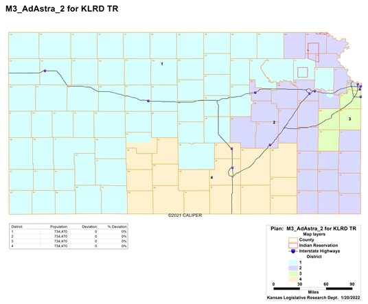
A map produced by Republicans in the House and Senate would place Lawrence in the 1st District, which stretches to the Colorado border, and split Wyandotte County between 2nd and 3rd districts. (Submitted)

by Sherman Smith, Kansas Reflector

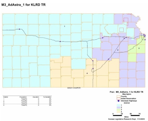
Topeka — Gov. Laura Kelly on Thursday vetoed a GOP-drawn congressional map that would divide the Kansas City metro and place Lawrence into a rural district that stretches to the Colorado border.

The Republican-dominated Legislature adopted the map, known as Ad Astra 2, along party lines and could attempt to override the governor’s veto. Democrats accused Republicans of gerrymandering congressional boundaries to make it more difficult for U.S. Rep. Sharice Davids, the only Democrat in the state’s congressional delegation, to get re-elected.

Wyandotte County residents said the map would dilute the voting power of a community where a majority of voters are Black or Latino. The map places the northern part of the county in the 2nd District while leaving the area south of Interstate 70 in the 3rd District, where Davids has won two terms.

Republicans offset the addition of Wyandotte County voters to the 2nd District by carving Lawrence out of Douglas County and placing it in the 1st District.

Lawmakers passed the map in Senate Bill 355 by a 26-9 vote in the Senate and 79-37 vote in the House.

Kelly, a Democrat running for re-election, said the Legislature ignored its own redistricting guidelines for preserving the voting power of minority communities and protecting communities of interest.

The Democratic governor said the map “does not follow these guidelines and provides no justification for deviation from those guidelines.”

“I am ready to work with the Legislature in a bipartisan fashion to pass a new congressional map that addresses the constitutional issues in Senate Bill 355,” Kelly said. “Together, we can come to a consensus and pass a compromise that empowers all people of Kansas.”

Republican leaders refused to say who exactly drew the Ad Astra 2 map and rejected criticism by Democrats, residents and advocacy groups. Senate President Ty Masterson, R-Andover, said Davids would win re-election with the redrawn boundaries — a contested assertion based on presidential votes in Anderson, Franklin and Miami counties.

Senate Republican leaders in a statement said they were disappointed in the governor’s veto.

“All in all, the Ad Astra 2 map will serve Kansas well, and accordingly, we will work to override the governor’s veto in short order,” the statement said.

Senate Minority Leader Dinah Sykes, D-Lenexa, said the governor’s veto provides lawmakers “an opportunity to reflect on our failures.”

“A once-in-a-decade constitutional responsibility must be treated with great care,” Sykes said. “The Legislature owes it to current and future Kansas voters to be good stewards of this process, and it’s clear the Ad Astra 2 map falls short.”

The ACLU of Kansas and other advocacy groups urged the governor to exercise her veto authority.

House Republican leaders in a statement said Kelly’s action makes it clear she is “beholden to New York special interests.

“This isn’t the first time the Legislature has had to step up to protect Kansans from Laura Kelly’s partisan agenda,” the statement said. “It is no coincidence she pulled out the veto pen just hours after the ACLU told her to.”

Rep. Brandon Woodard, D-Lenexa, responded to the statement on Twitter: “What in the dogwhistle politics does this mean?!”

House Minority Leader Tom Sawyer, a Wichita Democrat who served from 1987-1998 and has served since 2003, said Ad Astra 2 is “the most gerrymandered map I have seen in my legislative career.”

“It was an insult to Kansans,” Sawyer said. “I sincerely hope my colleagues across the aisle are dedicated to moving forward with a fair bipartisan map without gerrymandering and ensures every Kansan’s vote counts.”

Sen. J.R. Claeys, R-Salina, tweeted: “Live look at where we are now in the Kansas #KSLeg redistricting process” with an image that reads, “I just ignore and override. Push forward.”

Kansas Reflector stories, www.kansasreflector.com, may be republished online or in print under Creative Commons license CC BY-NC-ND 4.0.
See more at https://kansasreflector.com/2022/02/03/kansas-governor-vetoes-gop-map-that-divides-kansas-city-carves-out-lawrence/

State representative shows dislike for redistricting process

Views
Opinion column

by Murrel Bland

The way Tom Burroughs sees it, the congressional redistricting map, approved by the Kansas Senate Friday, Jan. 21, soon will sail through the Republican-dominated House of Representatives.

Burroughs, is the Democratic state representative from the 33rd District, which includes southwestern Wyandotte County. He is upset that the map splits Wyandotte County into two congressional districts along I-70. The area south of I-70 would be in the 3rd District; the area north would be in the 2nd District.

Such a map would make it very difficult, if not impossible, for a Democrat to be elected to Congress from Kansas. It could mean that U.S. Rep. Sharice Davids would lose her seat. In an interview with MSNBC, Davids said of the Republican efforts, “If you can’t beat them, cheat them.”

Burroughs attended 14 hearings on redistricting throughout Kansas last summer. He said that overwhelmingly, most people at the hearings favored keeping Wyandotte County in one congressional district.

Burroughs predicted that Gov. Laura Kelly, a Democrat, would veto map legislation. That would probably mean the lines then would be drawn by a federal judge as it was in 2012. That would mean that an unelected person would be doing the job that the Kansas Legislature should have done.

Dinah Sykes, the minority leader in the Kansas Senate, said the redistricting bill violated several redistricting guidelines agreed to by legislative leadership.

In the 1970s and 1980s, Wyandotte County was split into two Congressional Districts. Republican Larry Winn was from the 3rd District; Dr. Bill Roy and Martha Keys were both Democrats from the 2nd District. The advantage was having two people, one Republican and one Democrat, serving the same county.

There was an “alternative map” in the Kansas Senate proposed by Dennis Pyle, a senator from the 1st District, which is in far northeastern Kansas. Pyle proposed keeping Wyandotte County whole in the 2nd congressional district, which also includes Douglas, Shawnee and Riley counties.

State Sen. David Haley, who represents northeast and central Wyandotte County, said he voted for the Pyle map. He said Pyle, although a Republican, tends to be an independent thinker.

Murrel Bland is a former editor of The Wyandotte West and The Piper Press. He is an advisory director of Business West.

‘You have awakened a sleeping lion’: Kansas City residents denounce GOP congressional map

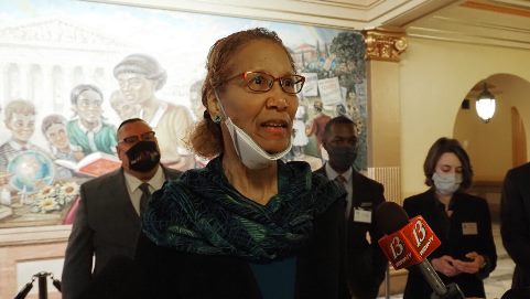
Connie Brown Collins, a Wyandotte County resident, said during a news conference Monday at the Statehouse in Topeka that lawmakers awakened a sleeping lion with their proposal to divide the Kansas City metro area between congressional districts. (Photo by Sherman Smith, Kansas Reflector)

by Sherman Smith, Kansas Reflector

Topeka — Wyandotte County resident Connie Brown Collins says new congressional boundaries passed by the state Senate appear to “literally cut through backyards” of several diverse communities.

Republicans in the Legislature have fast-tracked an effort to redraw congressional districts in a way that would divide the Kansas City metro area along Interstate 70.

As a result, Brown Collins said during a news conference Monday at the Statehouse, 39,000 Latino residents and 30,000 Black residents would be relocated from the 3rd District, the only one in Kansas currently represented by a Democrat, and into the 2nd District. This “population shuffle,” Brown Collins said, will decrease the voting power of a majority-minority vote.

“If legislators think we in Wyandotte County are snoozing through this travesty, that we are not aware or we do not care, think again,” Brown Collins said. “You have awakened a sleeping lion.”

Kansans for Fair Maps, a coalition of advocacy groups, organized the news conference to elevate the voices of residents in the Kansas City metro area who are upset about the proposed new map. They spoke in front of the Brown v. Board mural on the third floor, a tribute to the landmark civil rights case that ended segregation in public schools.

Senate and House redistricting panels introduced the Ad Astra map favored by Republicans during a hearing last week and heard overwhelming opposition in testimony. The Senate panel proceeded to pass a version of the map that corrected the oversight of splitting the Kickapoo Indian reservation between districts. On Friday, the full Senate endorsed Ad Astra 2.

The House panel held additional hearings Monday.

“The House process is still ongoing. It has been fair, deliberate and transparent,” the House Republican leadership said in a statement for this story. ” We look forward to seeing the results of the committee’s work.”

Under current lines drawn by courts a decade ago, the 3rd District currently includes the Kansas City metro area that sprawls across Wyandotte and Johnson counties. U.S. Rep. Sharice Davids, a Democrat, American Indian, and the first openly LGBTQ member of Congress from Kansas, won election there in 2018 and retained the seat in 2020.

Republicans redrew her district to eliminate Democrats’ votes in the northern half of Wyandotte County and move Republican strongholds from Anderson, Miami and Franklin counties into the district.

“The way this map is drawn really diminishes her chance of being reelected,” said Tom Witt, of Equality Kansas. “The voters chose her, and they chose her twice. And now Senate leadership is trying to choose different voters for her. I don’t know how the rest of you grew up, but I grew up in America where democracy matters.”

Thomas Alonzo said he has lived in Wyandotte County his entire life, except for when he served in the military. He said his Kansas City, Kansas, community’s interests are deeply tied to their neighbors to the south.

The Ad Astra map “demonstrates a lack of competent, moral and ethical leadership,” Alonzo said.

“There is nothing democratic or patriotic about deliberately cutting up a district to prevent its voters from having the ability to select individuals to represent us that will protect our interests,” Alonzo said.

Liz Meitl lives in Johnson County and works for the Kansas City, Kansas, public school district in Wyandotte County. She said there are thousands of others who work in one county and live in the other. Their lives are interconnected, she said.

“When you divide us by congressional districts, you are creating schisms, unnatural schisms that both perpetuate racist and systemic institutionalized inequalities and perpetuate a system in which the elites disenfranchise voters,” Meitl said.

Senate Republican leaders have dismissed concerns about the way the map affects the voting power of Democrats and communities of color. The map also moves heavily Democratic Lawrence from the 2nd District to the rural 1st District.

Senate President Ty Masterson, R-Andover, said all four members of congress would retain their seats based on 2020 election results, although Witt said that claim hasn’t been verified since underlying data was made available late Thursday.

“On balance,” Senate Republicans said in explaining their vote, “this map will serve the state well for the next decade.”

A map proposed by Republicans in the House and Senate would place Lawrence in the 1st District, which stretches to the Colorado border, and split Wyandotte County between 2nd and 3rd districts. (Submitted)

Kansas Reflector stories, www.kansasreflector.com, may be republished online or in print under Creative Commons license CC BY-NC-ND 4.0.
See more at https://kansasreflector.com/2022/01/24/you-have-awakened-a-sleeping-lion-kansas-city-residents-denounce-gop-congressional-map/