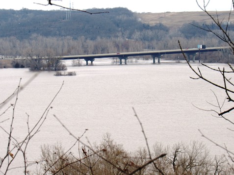
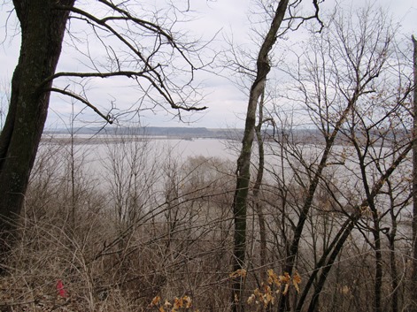
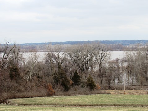
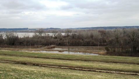
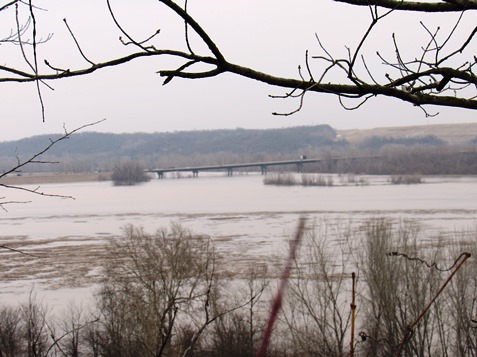
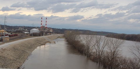
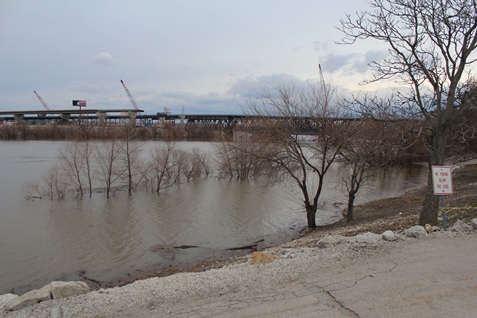
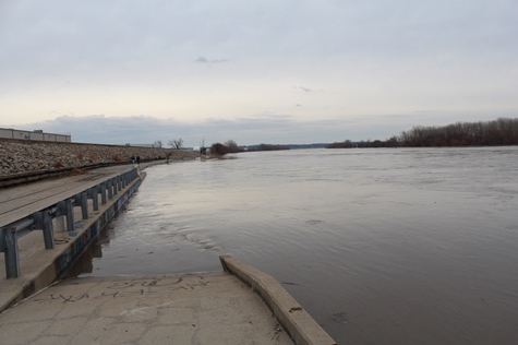
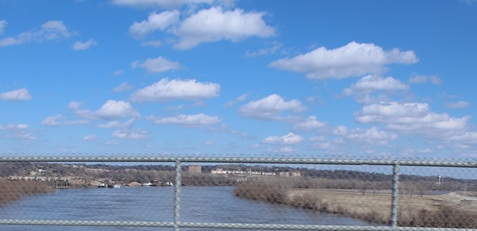
Water surrounded I-435 in the Wolcott area of Kansas City, Kansas, in this photo taken on Sunday morning from Wyandotte County Lake Park.A wide area of water was visible in the fields looking north of the spillway at Wyandotte County Lake Park on Sunday morning. The flooded area is between Wyandotte County Lake Park and the Missouri River.
As Missouri River water levels are declining on Sunday in Wyandotte County, water is expected to remain for some time in fields at Wolcott and at other locations on the river in Wyandotte County.
Local officials said on Saturday that flood water could remain in the fields for perhaps a week or two, depending on how much more water is released into the Missouri River and also on how much it rains upstream.
Local officials on Saturday said they were not aware of any residences here affected by the flood; some Wolcott businesses were flooded, and Wolcott Drive was closed to traffic.
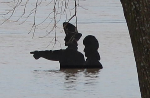
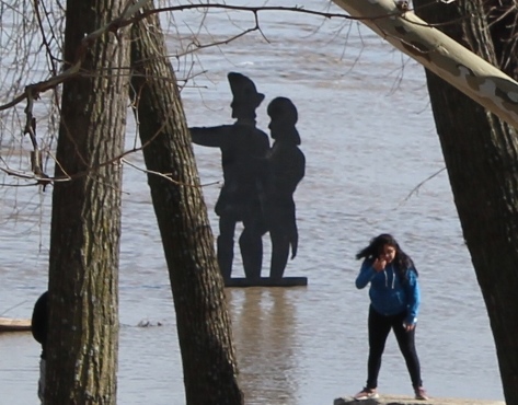
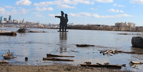
Local officials said flooding also was reported at Nearman Creek in Kansas City, Kansas. There also was high water at the Lewis and Clark statue in Kaw Point Park on Fairfax Trafficway in Kansas City, Kansas.
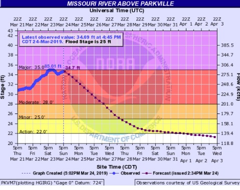
The Missouri River at Wolcott in Wyandotte County was still in the moderate stage on Sunday, and hydrology charts predicted it would go into minor flood stage on Tuesday and out of flood stage on Wednesday night. The river level was 34.69 feet on Sunday afternoon at this location.
Since that reading on Sunday afternoon, this river level increased to 34.76 feet at 7:45 p.m. Sunday.
Corps of Engineers officials today said in a news conference that they plan to hold water releases at Gavins Point dam in South Dakota at the present 24,000 cubic feet per second as long as conditions allow. Corps officials said today that they plan to increase the Gavins Point water releases to 30,000 cfs late next week.
Fort Randall, South Dakota, dam water releases will be 8,000 cfs today and Monday, according to Corps officials, which was down from the 12,000 cfs that had been announced on Saturday.
In a news release tonight, the Corps announced a change. It stated that it will increase releases from Gavins Point dam to 27,000 cfs on Monday, March 25, from the current 24,000 cfs.
The water releases may change according to water coming into the system upstream from snow melting and also from rain, according to officials.
A National Weather Service forecaster said there is still major flooding in the St. Joseph, Missouri, to Leavenworth, Kansas, area. The crest moved through the Kansas City area around 1 a.m. Sunday, is currently at Napoleon, Missouri, and is expected to be in Jefferson City, Missouri, on Tuesday and to the mouth of the river on Wednesday or Thursday.
There is flooding currently on the Big Sioux and James rivers that flow into the basin, with melting snow. This water could result in a one-foot rise on the Missouri River, perhaps in another week, according to the weather service forecaster.
There also is rain in the forecast over the basin area. Rain is possible in Kansas City from Wednesday night through Saturday, according to the weather forecast.
To check on roads affected by flooding, visit http://www.kandrive.org/kandrive/roads/#construction/K-5/-96.0040/38.7201/7.
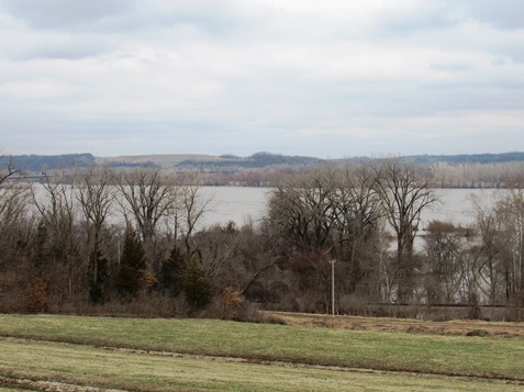
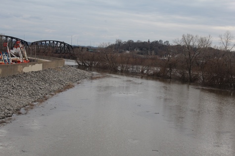
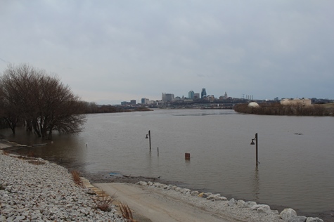
A view of flooded fields, with I-435 in the distance, in western Kansas City, Kansas, on Sunday morning, March 24. The photo was taken from Wyandotte County Lake Park.Another view of flooded fields looking north of the spillway at Wyandotte County Lake Park on Sunday morning.
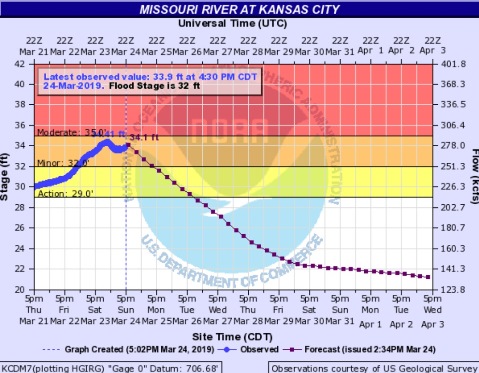
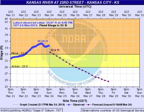
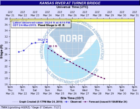
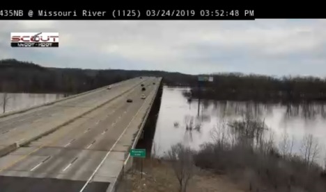
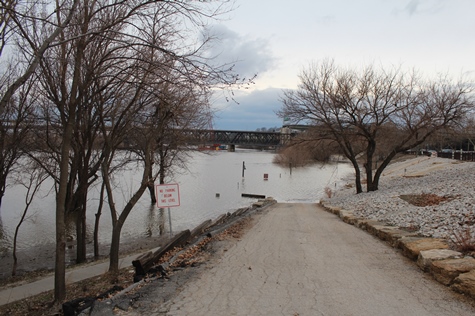
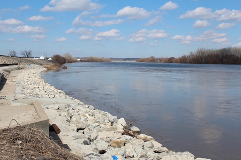
Another view of flooded fields looking north of the spillway at Wyandotte County Lake Park on Sunday morning.Flooding from the Missouri River as seen at 79th and Wolcott Road in Kansas City, Kansas, on Sunday morning.The Missouri River at Parkville, which applies to the Wolcott area of Kansas City, Kansas, was at 34.69 feet at 4:45 p.m. Sunday, March 24, lower than its crest of 35.01 feet at 1 a.m. Sunday. The river at this point currently is projected to decline out of flood stage by Thursday. The projections may be changed according to water entering the Missouri River upstream. (National Weather Service – USGS graphic)The Missouri River at Kansas City, where the gauge is south of the downtown Kansas City, Missouri airport, was lower this afternoon, at 33.9 feet, as compared to its crest of 34.41 feet on Saturday night. It is in minor flood stage currently, and is projected to decline. (National Weather Service -USGS graphic)The Kansas River at 23rd Street, where the gauge is at Kansas Avenue and the state line, not far from the bottoms, was at 35.67 feet on Sunday afternoon, where the flood stage is 33 feet. It crested at 36.38 feet on Saturday night. It is expected to decline, and soon will be out of the minor flood stage. (National Weather Service – USGS graphic)The Kansas River at the Turner Bridge was at 30.24 feet at 4:15 p.m. Sunday, and it is projected to decline in the next few days. It is not in flood stage, which is at 41 feet. (National Weather Service – USGS graphic)I-435 at the Missouri River on Sunday afternoon, in this KC Scout photo. Flood waters are on the east and west sides of I-435 in Wyandotte County, and they also are on the Missouri side of I-435. (KC Scout photo)
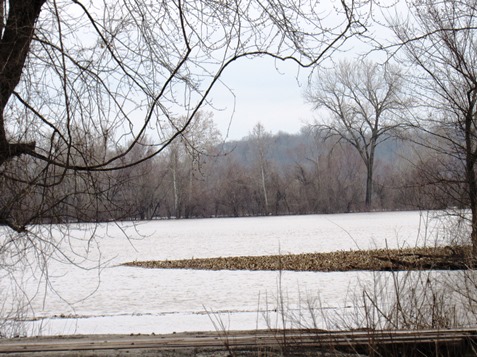
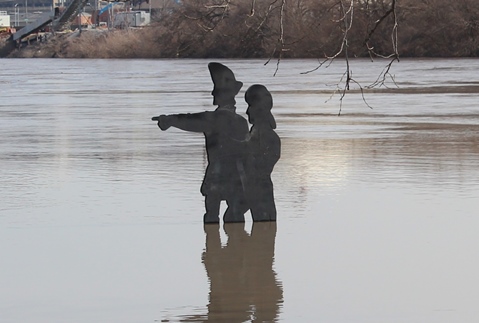
On Saturday afternoon, March 23, water was chest-high for the Lewis and Clark statue at Kaw Point Park in Kansas City, Kansas. The park is at the confluence of the Missouri and Kansas rivers. (Photo by Steve Rupert)Lewis and Clark were up to their knees on Friday afternoon, March 22, in the Missouri River at Kaw Point Park in Kansas City, Kansas. (Photo by Steve Rupert)Missouri River water was at the base of the statue on Sunday, March 17. (Photo by Steve Rupert)
by Mary Rupert
The Missouri River is expected to crest around 1 a.m. in Wyandotte County, according to Matt May, the county’s director of emergency management.
May said on Saturday evening that the 1 a.m. crest is the latest projection from the National Weather Service forecasters.
“We probably have another 6 inches in water elevation yet to go before we crest,” May said on Saturday evening.
It will stay at that elevation for about 12 hours, then it will start to recede, May said.
The river forecast is based on an assumption that water release levels upstream from the reservoirs will not change. If they do not change, the river will start to slowly decrease during the next week or two, he said. The forecast could change if for some reason higher levels of water are released from the reservoirs or if there is an unusual amount of rain along the system.
May said the forecast is “very fluid,” as it depends on different factors.
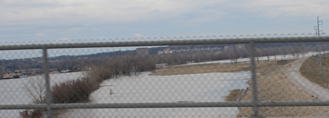
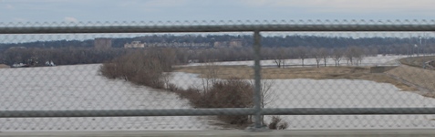
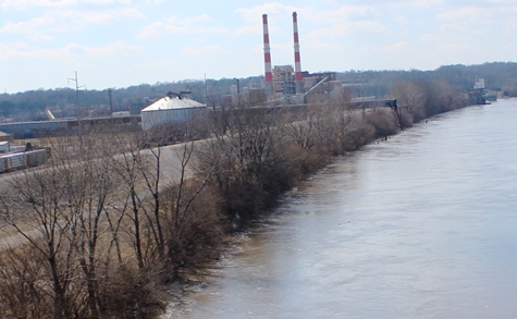
May said that as expected, there is water in low-lying areas north and east of Wolcott Drive, on both sides of I-435. There also is water by the BPU’s Nearman plant, which is located on the Missouri River near North 55th Street.
He said that was anticipated, and he said he has not heard any reports of any residential flooding. The power plant is protected by a large, tall berm, he said.
“We don’t think there’s any imminent threat to any homes that we’re aware of,” he said. It’s not a highly populated residential area.
Wolcott Drive is closed at Hutton Road to the west because of flooding. In that area, Wolcott Drive also is Highway K-5. May said he thinks that area of Wolcott will be impassable for the next 24 or 48 hours, depending on how fast the water recedes.
Besides a road closure on Wolcott Drive, a Union Pacific train track that runs parallel with the road is closed, with a few places under water, he said. Repairs are currently ongoing at that site, he said.
May said that any residents who have had problems in the past, such as water in their basements previously, should keep an eye on the conditions.
“If you have property susceptible to that, you probably already know it,” he said. People should be diligent, he said, but he doesn’t anticipate a lot more water.
A weather service forecast for major flooding this morning decreased to moderate flooding in mid-morning. Every time a levee breaches upstream, it drops the water level in the river here, May said. Once the water stabilizes, the level goes back up. The river levels in the forecast can’t be anticipated sometimes, and other times they can.
May is keeping his eye on water backflowing into tributaries, but added he didn’t anticipate anything happening with the creeks or tributaries, as there is only another 6 inches until the river crests.
He said the businesses along Wolcott Drive did a lot of preparation for the flooding. Sandbagging probably would not have worked, he said, because all it does is push the water in a different direction. It sometimes is good for protecting a piece of equipment or filling a gap, he added. The businesses were able to drive their trucks away to protect them, he added.
May does not believe the east side of Kansas City, Kansas, is at risk in this flood.
For example, on James Street the levees are much taller and the river is much wider, he said, so the area is not in danger. He said he is watching the Kansas River, which joins with the Missouri River at Kaw Point in Kansas City, Kansas, because the Missouri water could backflow into the Kansas River a little.
May and his colleagues have been taking bridge readings on the Kansas River every 12 hours, and found the water level has gone up about 3 feet during the last 48 hours, he said. He believes it will peak soon. The river is at 29.5 feet and flood stage is 41 feet, so he does not believe there will be any significant level of flooding on the Kansas River.
The Tuttle Creek reservoir near Manhattan, Kansas, has been holding back water, not releasing it, he said, so the Kansas River levels have been kept lower.
With this flood in Wyandotte County, there were no injuries, no displaced people and no shelters needed, he said.
There could be a possible need in the future to clean up any debris left behind by the flood, he added.
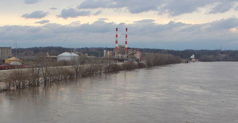
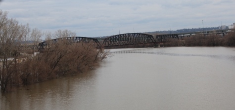
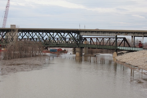
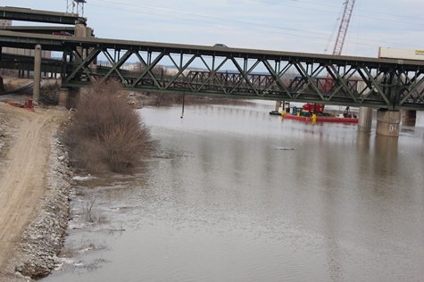
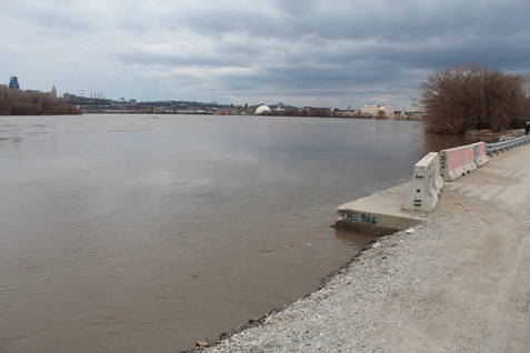
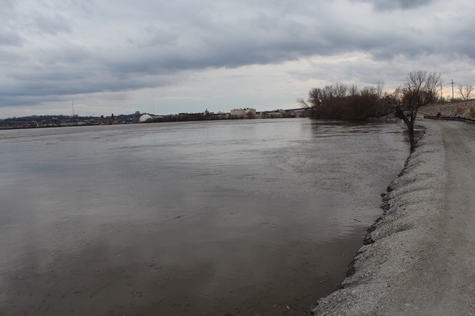
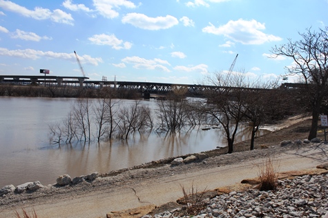
The Wolcott area and areas next to I-435 at the Missouri River in western Kansas City, Kansas, flooded on Saturday morning. This photo was taken from Wyandotte County Lake Park.The Missouri River, near the Fairfax area of Kansas City, Kansas, on the left, on Saturday afternoon, March 23. (Photo by Steve Rupert) The Missouri River, near the Fairfax area of Kansas City, Kansas, to the left, on Saturday afternoon, March 23. (Photo by Steve Rupert)The Missouri River to the left, with the Fairfax area of Kansas City, Kansas, to the right, on Saturday afternoon, March 23. (Photo by Steve Rupert)The Missouri River to the left, with the Fairfax area of Kansas City, Kansas, to the right, on Saturday afternoon, March 23. (Photo by Steve Rupert)The Kansas River from James Street in Kansas City, Kansas, on Saturday afternoon, March 23. (Photo by Steve Rupert)The Kansas River from James Street on Saturday afternoon, March 23. (Photo by Steve Rupert)The Kansas River from James Street on Saturday afternoon, March 23. (Photo by Steve Rupert)The Kansas River from James Street on Saturday afternoon, March 23. (Photo by Steve Rupert)A view of Kaw Point in Kansas City, Kansas, at the confluence of the Missouri and Kansas rivers, on Saturday afternoon, March 23. (Photo by Steve Rupert)
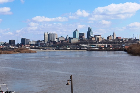
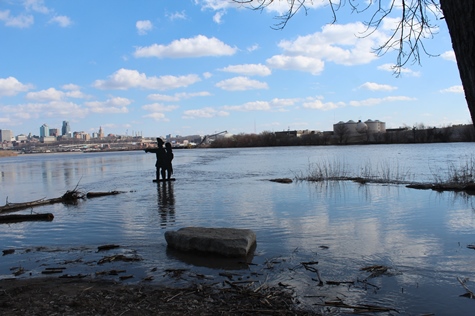
A view of Kaw Point in Kansas City, Kansas, at the confluence of the Missouri and Kansas rivers on Saturday afternoon, March 23. (Photo by Steve Rupert)A view of Kaw Point in Kansas City, Kansas, at the confluence of the Missouri and Kansas rivers, on Saturday, March 23. (Photo by Steve Rupert)A view of Kaw Point in Kansas City, Kansas, at the confluence of the Missouri and Kansas rivers, on Saturday afternoon, March 23. (Photo by Steve Rupert)A view of Kaw Point in Kansas City, Kansas, at the confluence of the Missouri and Kansas rivers, on Saturday afternoon, March 23. (Photo by Steve Rupert) A view of the Missouri River at Kaw Point in Kansas City, Kansas, on Saturday afternoon, March 23. Water levels were higher than on March 22. (Photo by Steve Rupert) A view of the Missouri River at Kaw Point in Kansas City, Kansas, on Saturday afternoon, March 23. (Photo by Steve Rupert) A view of the Missouri River at Kaw Point in Kansas City, Kansas, on Saturday afternoon, March 23. (Photo by Steve Rupert)
The Lewis and Clark statue at Kaw Point Park in Kansas City, Kansas, was treading water on Wednesday afternoon. The water level has increased since Sunday. Kaw Point is at the confluence of the Missouri and Kansas rivers in Kansas City, Kansas. (Photo by Steve Rupert)
by Mary Rupert
While flood warnings have been issued for the Missouri River at Kansas City, residences in Wyandotte County are not expected to be in danger, according to Wyandotte County Emergency Management Director Matt May.
May has been very busy the past few days with flood monitoring and preparations. With the current forecasts, there has not been a need to deploy any sandbags here, May said. At this time, Wyandotte County residences are not in any danger, he said.
Extensive flooding and loss of homes has taken place upstream in Nebraska with this flood. Significant flooding has been reported at St. Joseph, Missouri, Atchison, Kansas, and Leavenworth, Kansas.
Wyandotte County is under a flood warning for the Missouri River above Parkville, Missouri, currently in moderate flood stage, which for Wyandotte County means that the Wolcott levees are at risk of being overtopped, according to the National Weather Service hydrology charts. The river at that point is scheduled to crest on Friday, according to the weather service.
Businesses on Wolcott Road in Kansas City, Kansas, including Lakeside Speedway and a cement company, could be affected.
May said the new river gauge at Parkville really is in the middle of I-435 over the Missouri River, between Wyandotte and Platte counties. An electronic device takes a reading off the surface of the river.
“Because it’s so close to our area of concern, it’s very predictive of what’s going to happen to us,” May said.
The flood stages are based not only on how high the river is, but also on the potential for impact, May said. One of the differences between moderate and minor flood stages is if there are structures in the path of the flooding, he said. If Lakeside Speedway and the cement company had not been located near the river, the river stage probably would have been minor.
Also, he said the differences between the minor and moderate flood stages are not the same at every place. Flooding levels can be different at different places on the river.
Wyandotte County has been placed under a minor flood warning for Friday and Saturday for the Missouri River at Kansas City, which is located south of the downtown airport in Kansas City, Missouri, close to the City Market, east of Kansas City, Kansas, and the state line, and not far from Kaw Point.
On Tuesday, Wyandotte County was placed under a minor flood warning for Friday for the Kansas River at 23rd Street, a location that is at Kansas Avenue and the state line. That location is in the Armourdale area on the Kansas side, and near the American Royal on the Missouri side.
Under the minor flood warnings, no homes would be affected, May said.
Two other gauges in Wyandotte County, the Kansas River over the Turner Bridge, and Turkey Creek at Southwest Boulevard, are well below flooding.
May said he anticipated seeing a higher water level where the Missouri and Kansas rivers come together at Kaw Point in Kansas City, Kansas. He added they are keeping a watch on any backwash from the Missouri River into the Kansas River.
While they are watching the Kansas River, it is not a cause for concern at this time, he said.
This has been an unusual flooding event, May said, because predicting it is difficult. The predictions were difficult because the water is not coming from rainfalls here, but from runoff in the Dakotas, he said. Even if it rains hard here, it would have little effect on the flooding, he said.
The snowpack melting in the north, the water releases from the upstream reservoirs and levees failing to the north have had an effect on predicting the flooding, he said. When levees upstream failed, that relieved the pressure and water spread out into the fields, he said. Then not as much water traveled as fast to the Kansas City area. But there was a rebound effect, and once a flooded area fills, it bounces back, he said.
Water releases were increased March 14 and 15 from reservoirs upstream, then they were gradually reduced. Originally it was thought the river would crest here on Tuesday, but the crest changed to Friday, as levees failed upstream.
May said he has learned not to take the forecast predictions too much for granted unless they are within a 48-hour period.
Increased flows are being seen downstream of Rulo, Nebraska, according to Corps of Engineers officials at a news conference Wednesday.
According to Corps of Engineers officials, a lot of flood preparations and sandbagging currently are taking place in Doniphan County, Kansas, Buchanan and Holt counties, Missouri. St. Joseph, Missouri, is currently in major flood stage and Atchison, Kansas, is projected to go into major flood stage. So far, more than 470,000 sandbags have been issued, with 3.6 million available, according to officials.
A levee was breached this morning at Craig, Missouri, and the city was evacuated, according to a Corps of Engineers official.
Corps of Engineers officials said many of the cities to the north and south of Kansas City on the Missouri River are currently flooding.
Kansas River reservoir water releases have been reduced to a minimum, according to officials. Parts of the Missouri River upstream are now closed to use.
Water releases upstream on the Missouri River also continued to be reduced from the reservoirs, and the Gavins Point dam releases were planned to be down to 20,000 cubic feet per second on Thursday, officials said.
The Fairfax area of Kansas City, Kansas, was at the right of this photo of the Missouri River on Wednesday afternoon. (Photo by Steve Rupert)The Missouri River, with the Fairfax area of Kansas City, Kansas, on the left side of the photo, was well within the floodwalls as of Wednesday afternoon. (Photo by Steve Rupert) A view at Kaw Point, which is at the confluence of the Missouri and Kansas rivers in Kansas City, Kansas, showed the Kansas River to the right of the photo on Wednesday afternoon. (Photo by Steve Rupert)Across from Kaw Point is Kansas City, Missouri, in this photo taken Wednesday afternoon. The river level is below the floodwall there. (Photo by Steve Rupert)Water was a little higher than on Sunday on the banks of the Missouri River at Kaw Point in Kansas City, Kansas. (Photo by Steve Rupert) Another view of the Lewis and Clark statue at Kaw Point Park in Kansas City, Kansas, which was treading water on Wednesday afternoon. The water level has increased since Sunday. Kaw Point is at the confluence of the Missouri and Kansas rivers in Kansas City, Kansas. (Photo by Steve Rupert)