Planning Commission denies zoning change for Piper area multifamily housing project

Residents turned out to speak against a Piper area multifamily housing project at Monday night’s City Planning Commission meeting.

After hearing several residents speak against the project, and no neighbors speaking in favor of it, the Planning Commission voted unanimously to deny a change of zone for the project. The proposed location was at 2341 N. 104th Terrace, north of The Legends Outlets. The UG staff had recommended approval of the project.

The project next goes to the Unified Government Commission at the end of June for consideration.

The project, as proposed, included 10 single-family homes, 29 duplexes with a total of 58 units, and eight three-story and two four-story apartment buildings with 344 units on 38.3 acres, according to agenda information.

Jim Calvert with Worcester Investments said the rents for the units would range from $920 a month to $2,007 a month.

He said after neighbors brought up traffic concerns, he engaged outside traffic consultants for the project. He said based on studies, existing road networks will manage the traffic. The project has several amenities, such as a swimming pool, walking trails, a pickleball court and a retention pond.

Several residents spoke against the project. Lynn Melton, who lives a few miles from the proposed project, said she believed the project would not enhance property values for homeowners nearby. She said schools were currently overcrowded in the area, public safety was stretched to the limit, and she also said there were a lot of subdivisions that have trouble with retention ponds. She did not believe the project was a good fit for the neighborhood.

Erica Turney, who lives nearby, said she thought the project would have a negative effect on the intersection of 104th and Parallel as well as increased traffic on Georgia Avenue. By cutting through to an existing subdivision, it would put children and families at risk from the traffic, she believes.

“We’re already overcrowded in the Piper school district as it is,” she said.

She said nearby apartments at Village West can’t stay full, and that developments were being added too quickly in the area.

Jim Reitemeier, a nearby resident, said he had concerns about traffic, and residents thought schoolchildren could be at risk.

Adding an exit for the new development through an existing subdivision was “the straw that broke the camel’s back,” he said.

Reitemeier said there were underground streams under Rowland Avenue, and he was concerned about how the increased traffic would affect the future of the street. A large retention pond planned for the development would be an attractive nuisance, he said. He also questioned the need for apartments in the area.

Calvert said drainage problems have been there under I-435 for years and the development would not make it any better or worse. As far as the new development entrance going through an existing subdivision, Calvert said that was a UG design request. Originally the developer did not want to have an entrance through an existing subdivision.

Another neighbor, Kelly Burrell, said she moved to the neighborhood because it was quiet. Her concern is that traffic has been getting worse and children could be in danger with increased traffic from the apartments and development.

Piper just passed a bond issue, and she said she was afraid that more money would have to come out of the homeowners’ pockets, for school taxes for more school buildings if more than 300 housing units were added.

”I don’t think it’s the best use of our money,” she said.

Brenda Waters, a nearby resident, agreed with the concerns about school, safety, traffic and other issues. She also said she thought the developers wouldn’t get the amount of rents they wanted, and would eventually settle for contracts with agencies to house former prisoners or those with mental health problems. People need to understand what will happen if the owner or manager can’t rent these units, she said.

“This is all about money,” she said.

The motion to deny the change of zone was based on incompatibility with the neighborhood, safety, schools and traffic. Another motion to deny the master plan amendment was based on a detrimental impact related to infrastructure, safety, schools and incompatibility. The vote was unanimous to deny the applications.

Several other planning and zoning issues were on the agenda for the Monday night meeting. However, a few items were taken off the agenda because of issues involving the item’s wording in a legal publication.

The Planning Commission heard from one woman after 11:30 p.m. Monday, at the end of the meeting, who said she had been waiting almost six hours to speak about her zoning application. She said she didn’t know it had been taken off the agenda.

Planning Commission to meet tonight

The Kansas City, Kansas, City Planning Commission will meet at 6:30 p.m. Monday, June 13.

The meeting will be available to the public on Zoom.

Also, the Commission Chambers will be open to the public at 701 N. 7th St., lobby level, Kansas City, Kansas.

The Board of Zoning Appeals will meet at 6 p.m. Monday, June 13, prior to the Planning Commission meeting.

On the agenda for the City Planning Commission:

• 4136 Springfield St., Kansas City, Kansas, change of zone from planned single-family district to planned apartment district to build two triplex units, Jeff Meadow with Open Door Homes.

• 2017 N. 104th Terrace, change of zone from agriculture and single-family districts to planned two-family and planned apartment districts for a mixed density residential development, duplexes and apartment buildings at 2341 and 2017 N. 104th Terrace and 10332 Parallel Parkway, Jim Calvert, Worcester Investment. Also, Master Plan Amendment.

• 4411 N. 67th St., change of zone from agriculture and limited business districts to agriculture, single-family and limited business districts for urban residential uses and church, John Emanuels.

• 3020 N. Baltimore St., change of zone from planned apartment district to agriculture district to construct a single-family residence with urban farming at 3015 and 3020 Baltimore Street to sell produce and farm goods grown on the property, two single-family lots, Kalla McLaughlin, City Beautiful Enterprise. Also, a home occupation special use permit for the address. Also a preliminary plat.

• 3430 N. 115th, change of zone from county agriculture district to city agriculture district to subdivide a lot at 3430 N. 115th Street, Andrea Weishaubt, Atlas Surveyors. Also, change of zone from county to city agriculture to subdivide the lot at 3548 N. 115th St. Also, final plat for two residential lots.

• 2513 W. 46th Ave., special use permit for a short-term rental.

• 146 S. 18th St., special use permit for a liquor store, Dana Blay, DBL Architecture.

• 5044 Powell, renewal of a home occupation special use permit for a beauty salon.

• 2205 S. 88th, special use permit for auto sales, Hariot Singh, Elite Motor Group KC.

• 2205 S. 88th, special use permit for auto repair, Manjit Kaur, City Truck and Tire Repair.

• 8440 Gibbs Road, renewal of s pecial use permit to continue to store boats, trailers, vehiclese, construction equipment and farm equipment for retail sales, Copart of Kansas.

• 2089 N. 1st St., renewal of special use permit to continue to keep storage containers and a moveable high tunnel for a training farm and community garden, Linda Siemens, Cultivate Kansas City.

• 1810 N. 1st St., special use permit to keep storage containers and a greenhouse, Brien Darby, Cultivate Kansas City.

• 620 Tenny Ave., special use permit to operate a short-term rental, Marc Winkler, Purple Holdings.

• 3914 N. 59th St., special use permit to store construction equipment, Tobias Sandoval Suarez.

• 0 Kansas Ave., preliminary plat for the Rock Island Bridge Commercial Development, Rock Island Bridge on Kaw, also known as 557 River Park Drive.

• Master plan amendment for telecommunication towers on light poles used for stadiums and athletic fields in residential zones.

• Ordinance to permanently expand the ability of farmers’ markets, mobile vending and mobile markets to sell food, drinks and merchandise on public rights-of-way and parking lots.

To connect to the Zoom meeting, visit
https://us02web.zoom.us/j/86136904011?pwd=NWwvTW9ZSlM5a1NvK3hiMFcxd0hHQT09
The passcode is 898859.

City Planning Commission approves Armourdale master plan

The Armourdale master plan passed unanimously Monday night at the City Planning Commission meeting.

by Mary Rupert

The City Planning Commission voted unanimously on Monday night to adopt the Armourdale master plan.

Andrew Moddrell, project consultant from PORT Design, whose group led the master plan project, said at the Zoom meeting that there was good response from most of the Armourdale residents that they interacted with, and the residents shared their stories and priorities.

The project hired some Armourdale residents to help gather citizen input, he said. A website, armourdalestrong.com, was created.

In answer to a question from Planning Commission Chairman Jeff Carson, Moddrell said some of the Armourdale residents wondered if the UG planners were going to be here today and gone tomorrow, but after months of work there, they gained the confidence of many.

Moddrell noticed that Armourdale residents shared stories about their everyday lives, such as some young residents letting them know they like to walk in alleys because trucks travel too fast on the streets.

Since last month’s presentation to the Planning Commission and the UG Commission, there has been an open house held Sept.21 for residents, and there have been other meetings, also, according to Moddrell.

The master plan also covered some industrial and labor history, as well as the rich Hispanic heritage, of the Armourdale neighborhood in the southeast part of Kansas City, Kansas, he said. The area received its name from the former Armour meatpacking plant and the stockyards in the bottoms. The area faced a legacy of negative developments, such as flooding, population decline, segregation, redlining and displacement, he said.

It was also isolated, as it was surrounded by rails, the river and industrial uses, he said.

With the master plan, the UG is hoping to turn the area around from disinvested, deteriorated, neglected, isolated, vulnerable and segregated to a safe, inclusive, stimulating and attractive place.

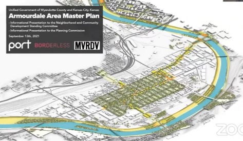
The master plan outlined five areas and different strategies. One with the longest list of strategies was the neighborhood core, where housing solutions are part of the focus, Moddrell said. Also important is to increase the capacity of Armourdale community-based organizations, he added.

Commercial corridors were discussed, including Osage Avenue and Kansas Avenue. The master plan wants to build upon the existing structure, and Osage Avenue would be the heart of the neighborhood, he said.

The plan would encourage the walkability of the area, integrate green and infrastructure upgrades and add bus stops.

The master plan also mentioned access to fresh food, public spaces, bike lanes and cultural amenities for Armourdale.

Industrial plans for the area would expand access, encourage recruitment services, bring service to Armourdale, encourage high performance industrial parcels, capture stormwater, and increase sustainable operation of industry in Armourdale.

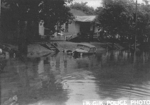
Hit hard by the 1951 flood, as well as the 1903 and 1908 floods, Armourdale has undergone changes caused by natural disasters. Unlike a former era, building residential homes in the Armourdale area now is being encouraged. Development in the area is being spurred by a federal levee project that strengthens flood protection.

The 1951 flood prevented motor vehicles from traveling in the Armourdale community of Kansas City, Kansas. The Armourdale community was severely damaged by the flood, and many residents resettled in other areas. (File photo courtesy of the Wyandotte County Museum, originally from the Kansas City, Kansas, police department)
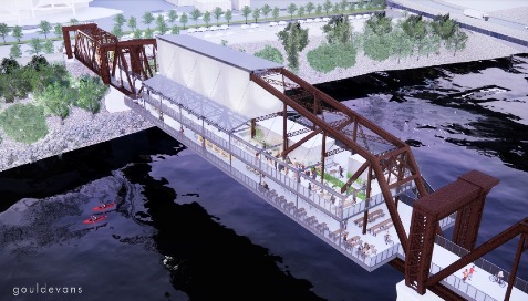
The Rock Island Bridge project being planned for an unused bridge on the Kansas River in the Armourdale area is one example of viewing the Kansas River as an asset instead of a threat. The bridge project would be a tourist destination, according to plans. (Architect’s drawing)

The Kansas River, formerly considered to be a threat from flooding, is viewed as an asset by the master plan. Currently, efforts are underway to develop areas around the river, such as the Rock Island Bridge, as destination tourist sites.

The master plan recommends that the West Bottoms have its own master plan, Moddrell said.

Among the options for the river development in the West Bottoms would be an extension of projects around HyVee Arena, a route for riverfront destination including more civic-minded development, or a logistics and industry hub.

Planning Commissioner Karen Jones said she saw the whole master plan effort as “better late than never.”

“For decades, Armourdale has languished,” she said. She hopes the area now will be moving forward.

She added community engagement of this project was great.

However, she said that some of the good-paying jobs in Armourdale, jobs paying more than $40,000 a year, are going to people who live outside of Armourdale. The average income in Armourdale is around $34,000, she added.

“For sustainability purposes, education is a big component,” Commissioner Jones said. It will take education for residents to get some of the higher-paying jobs. Currently, 50 percent of the people in the area do not have high school diplomas, she added.

Planning Commissioner Evelyn Hill said she appreciated this report, and noted the intergenerational participation it was able to obtain. She also asked if residents were concerned about air quality.

Moddrell said an appendix to the report by Clean Air Now and Beto Lugo provided an air study of Armourdale. While there were not a lot of complaints from residents, there is pollution from trains, trucks and some industries, according to Moddrell.

For the most part, industries around Armourdale currently are logistics-oriented, not big smokestacks and heavy manufacturing, he said. The Clean Air report recommends possible changes to truck routes in Armourdale, he said.

Osage Avenue doesn’t need to be a truck route, he said. At some point in the future, trucks could be routed through Kansas Avenue or Cheyenne. That would strengthen the neighborhood core and Osage could see more pedestrian traffic, he said.

Planning Commission Chair Carson added his vote of support to bring the tally to 6-0 on the master plan, which is expected to go before the Unified Government Commission for a final vote at a later date.

Planning Director Gunnar Hand said this project included a lot of community engagement. He hoped it signals a change where the community, not the planning department, is at the center of the effort. There was a lot of effort to get all UG departments engaged in it, he added.

Monica Mendez, Armourdale Renewal Association executive director, said at the meeting that it was the first time they had seen a lot of effort to get Armourdale residents involved.

Claudine Sanders, vice president of the Armourdale Renewal Association, also spoke in favor of the master plan.

The master plan also is online at https://www.armourdalestrong.com/master-plan-documents.

See earlier story at https://wyandotteonline.com/public-open-house-today-on-armourdale-master-plan/.