Ground broken on $539 million levee project

Ground was broken on Wednesday for a $539 million levee project to reduce flooding along the Missouri and Kansas rivers. (Photo from U.S. Rep. Sharice Davids’ office)

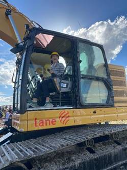
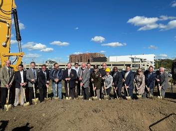
Ground was broken today on a $539 million levee project that is expected to reduce flooding and improve infrastructure along the Missouri and Kansas rivers in the Kansas City area.

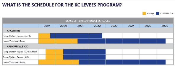
The project is scheduled to be completed in 2026, according to officials.

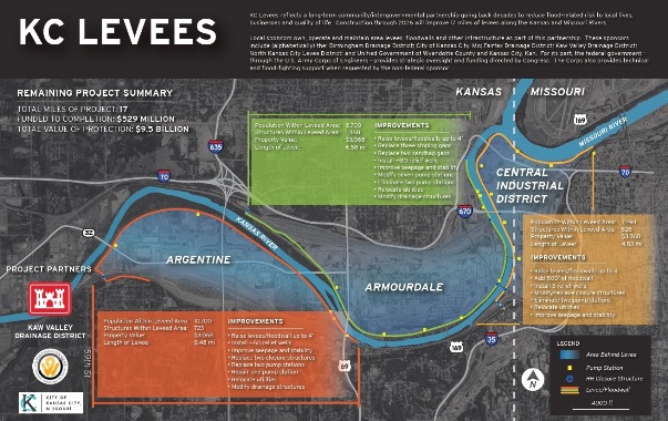
When finished, the project will improve 17 miles of levees along the Kansas and Missouri rivers, protecting 32 square miles of residential, industrial and commercial areas containing 100,000 jobs, 7,000 structures and $25 billion in investments.

The $529 million project received federal funding through the Bipartisan Budget Act of 2018. The collaboration of local communities including Kansas City, Kansas, and Kansas City, Missouri, with the U.S. Army Corps of Engineers and the Kaw Valley Drainage District led to the effort to get the funding legislation passed in Congress.

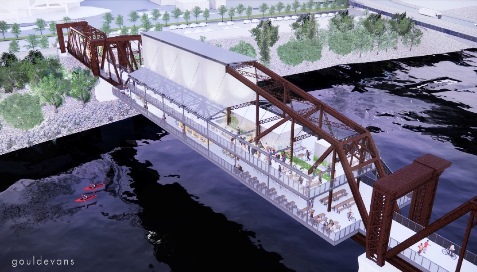
“Bolstering the levee system in Wyandotte County and surrounding communities is critically important,” Mayor David Alvey said. “These improvements have and will protect the safety of persons who live and work near and behind the floodwalls and levee system, protecting homes, businesses, and billions in property and infrastructure. Improving its reliability and resiliency now ensures these systems perform in future flood events, minimizing the impact on life and property. Moreover, levee enhancements can also act as a catalyst to connecting people, providing new bike and hike paths along the river that expand recreation opportunities and improve quality of life in our communities.”

U.S. Rep. Sharice Davids, vice chair of the House Committee on Transportation and Infrastructure, attended the groundbreaking.

“Kansans and all those who live along the Missouri and Kansas rivers know just how much devastation floods can cause in our communities – and it’s only gotten worse in recent years,” Rep. Davids said. “This new project will invest in our levee infrastructure resulting in safer neighborhoods and new and permanent economic development opportunities for local communities. I am excited for both the immediate and long-term benefits that will follow.”

The Weather Channel has ranked Kansas City the fifth most vulnerable U.S. city to the effects of climate change, particularly flooding. Rep. Davids has advocated for flood safety at the federal level, securing funding for the national levee safety initiative in the FY 2020 appropriations bill and outlining potential solutions to the challenges communities in Kansas are facing in response to extreme weather. Most recently, Rep. Davids, in partnership with local governments, successfully secured the maximum amount of federal funding for the Upper Turkey Creek levee project.

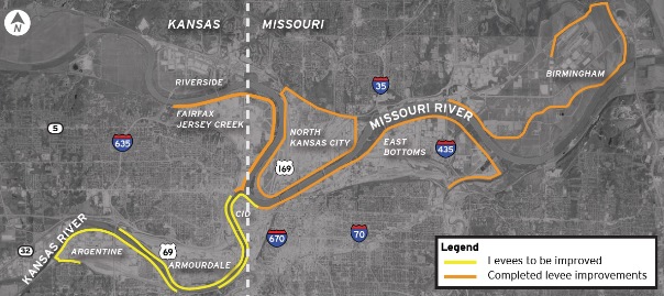
More than 27,000 residents and 2,700 businesses and structures benefit from the reduced risk of potential flooding produced by approximately 32 miles of existing levees and floodwalls along the Kansas and Missouri Rivers in Kansas City, Kansas, and Kansas City, Missouri, according to a UG spokesman.

This system of levee units, which protects the safety and economic vitality of the Argentine, Armourdale, and Central Industrial District (CID) levee units, among others, will be further strengthened by improvements that began construction in 2019.

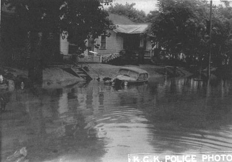
The levee improvements stem from a 1993 flood event during which water crested near the top of many local levees and floodwalls. This highlighted the need to improve flood infrastructure and reduce risk throughout Greater Kansas City, the UG spokesman stated.

Levee improvements already have taken place in three of the seven local levee units: Fairfax-Jersey Creek, North Kansas City and East Bottoms. Additional improvements will be constructed through 2026 in the Argentine, Armourdale and CID levee units.

U.S. Rep. Sharice Davids helped to break ground Wednesday on a new $529 million levee project to reduce flooding along the Missouri and Kansas rivers. (Photo from U.S. Rep. Sharice Davids’ office)
The KC Levees project schedule shows work scheduled for Armourdale and Argentine through 2026. (Information from KC Levees project)
Levees remaining to be improved include Argentine, Armourdale and the Central Industrial District. (Information from KC Levees project)
A graphic outlines the levee improvements to be made in the Argentine, Armourdale and Central Industrial District. To see this information in larger detail, visit https://www.wycokck.org/files/assets/public/public-works/engineering/documents/public-works-kc-levees-program-overview.pdf. (Information from KC Levees project)

City Planning Commission approves Armourdale master plan

The Armourdale master plan passed unanimously Monday night at the City Planning Commission meeting.

by Mary Rupert

The City Planning Commission voted unanimously on Monday night to adopt the Armourdale master plan.

Andrew Moddrell, project consultant from PORT Design, whose group led the master plan project, said at the Zoom meeting that there was good response from most of the Armourdale residents that they interacted with, and the residents shared their stories and priorities.

The project hired some Armourdale residents to help gather citizen input, he said. A website, armourdalestrong.com, was created.

In answer to a question from Planning Commission Chairman Jeff Carson, Moddrell said some of the Armourdale residents wondered if the UG planners were going to be here today and gone tomorrow, but after months of work there, they gained the confidence of many.

Moddrell noticed that Armourdale residents shared stories about their everyday lives, such as some young residents letting them know they like to walk in alleys because trucks travel too fast on the streets.

Since last month’s presentation to the Planning Commission and the UG Commission, there has been an open house held Sept.21 for residents, and there have been other meetings, also, according to Moddrell.

The master plan also covered some industrial and labor history, as well as the rich Hispanic heritage, of the Armourdale neighborhood in the southeast part of Kansas City, Kansas, he said. The area received its name from the former Armour meatpacking plant and the stockyards in the bottoms. The area faced a legacy of negative developments, such as flooding, population decline, segregation, redlining and displacement, he said.

It was also isolated, as it was surrounded by rails, the river and industrial uses, he said.

With the master plan, the UG is hoping to turn the area around from disinvested, deteriorated, neglected, isolated, vulnerable and segregated to a safe, inclusive, stimulating and attractive place.

The master plan outlined five areas and different strategies. One with the longest list of strategies was the neighborhood core, where housing solutions are part of the focus, Moddrell said. Also important is to increase the capacity of Armourdale community-based organizations, he added.

Commercial corridors were discussed, including Osage Avenue and Kansas Avenue. The master plan wants to build upon the existing structure, and Osage Avenue would be the heart of the neighborhood, he said.

The plan would encourage the walkability of the area, integrate green and infrastructure upgrades and add bus stops.

The master plan also mentioned access to fresh food, public spaces, bike lanes and cultural amenities for Armourdale.

Industrial plans for the area would expand access, encourage recruitment services, bring service to Armourdale, encourage high performance industrial parcels, capture stormwater, and increase sustainable operation of industry in Armourdale.

Hit hard by the 1951 flood, as well as the 1903 and 1908 floods, Armourdale has undergone changes caused by natural disasters. Unlike a former era, building residential homes in the Armourdale area now is being encouraged. Development in the area is being spurred by a federal levee project that strengthens flood protection.

The 1951 flood prevented motor vehicles from traveling in the Armourdale community of Kansas City, Kansas. The Armourdale community was severely damaged by the flood, and many residents resettled in other areas. (File photo courtesy of the Wyandotte County Museum, originally from the Kansas City, Kansas, police department)
The Rock Island Bridge project being planned for an unused bridge on the Kansas River in the Armourdale area is one example of viewing the Kansas River as an asset instead of a threat. The bridge project would be a tourist destination, according to plans. (Architect’s drawing)

The Kansas River, formerly considered to be a threat from flooding, is viewed as an asset by the master plan. Currently, efforts are underway to develop areas around the river, such as the Rock Island Bridge, as destination tourist sites.

The master plan recommends that the West Bottoms have its own master plan, Moddrell said.

Among the options for the river development in the West Bottoms would be an extension of projects around HyVee Arena, a route for riverfront destination including more civic-minded development, or a logistics and industry hub.

Planning Commissioner Karen Jones said she saw the whole master plan effort as “better late than never.”

“For decades, Armourdale has languished,” she said. She hopes the area now will be moving forward.

She added community engagement of this project was great.

However, she said that some of the good-paying jobs in Armourdale, jobs paying more than $40,000 a year, are going to people who live outside of Armourdale. The average income in Armourdale is around $34,000, she added.

“For sustainability purposes, education is a big component,” Commissioner Jones said. It will take education for residents to get some of the higher-paying jobs. Currently, 50 percent of the people in the area do not have high school diplomas, she added.

Planning Commissioner Evelyn Hill said she appreciated this report, and noted the intergenerational participation it was able to obtain. She also asked if residents were concerned about air quality.

Moddrell said an appendix to the report by Clean Air Now and Beto Lugo provided an air study of Armourdale. While there were not a lot of complaints from residents, there is pollution from trains, trucks and some industries, according to Moddrell.

For the most part, industries around Armourdale currently are logistics-oriented, not big smokestacks and heavy manufacturing, he said. The Clean Air report recommends possible changes to truck routes in Armourdale, he said.

Osage Avenue doesn’t need to be a truck route, he said. At some point in the future, trucks could be routed through Kansas Avenue or Cheyenne. That would strengthen the neighborhood core and Osage could see more pedestrian traffic, he said.

Planning Commission Chair Carson added his vote of support to bring the tally to 6-0 on the master plan, which is expected to go before the Unified Government Commission for a final vote at a later date.

Planning Director Gunnar Hand said this project included a lot of community engagement. He hoped it signals a change where the community, not the planning department, is at the center of the effort. There was a lot of effort to get all UG departments engaged in it, he added.

Monica Mendez, Armourdale Renewal Association executive director, said at the meeting that it was the first time they had seen a lot of effort to get Armourdale residents involved.

Claudine Sanders, vice president of the Armourdale Renewal Association, also spoke in favor of the master plan.

The master plan also is online at https://www.armourdalestrong.com/master-plan-documents.

See earlier story at https://wyandotteonline.com/public-open-house-today-on-armourdale-master-plan/.

Public open house today on Armourdale master plan

A new Armourdale area master plan, in draft form, is available. There is a public open house from 3 p.m. to 7 p.m. today on the master plan at Armourdale Community Center, 730 Osage Ave., Kansas City, Kansas.

Fifty years after the devastating 1951 flood, a new Armourdale master plan will try to improve the neighborhoods next to the Kansas River on the southeast side of Kansas City, Kansas.

A public open house on the draft Armourdale master plan will be held from 3 p.m. to 7 p.m. today, Sept. 23.

The open house will be held at the Armourdale Community Center, 730 Osage Ave., Kansas City, Kansas.

The public may attend and offer comments on the draft area master plan.

The master plan also is online at https://www.armourdalestrong.com/master-plan-documents, and the public may comment at this website.

The Unified Government planning department staff has been meeting with groups and individuals in the Armourdale area during the past nine months to receive comments for the master plan. A steering committee has been working on the project.

The master plan was released this week, and will be a guide to future investment in the Armourdale community, according to UG officials. It is the first Armourdale master plan since 1979.

The Armourdale master plan was presented to the UG Neighborhood and Community Development Committee on Monday, Sept. 13, and also to the City Planning Commission on Sept. 13. Another presentation is scheduled to be given to the UG Commission Sept. 30.

According to UG officials, the 300-page master plan will go before the UG Commission at a later date, probably October, for final approval.

They would like to turn a cycle of decline into a cycle of prosperity, Gunnar Hand, UG planning director, told the NCD Committee on Sept. 13.

“The plan builds upon the work underway by the Unified Government to reimagine the Kansas River,” Hand stated in a news release. “Connecting this neighborhood to these investments will ensure this work benefits existing and future Armourdale residents and small business owners.”

“After a century of ambiguity,” Hand said in the statement, “this plan ensures that the existing residential community is sustainable and vibrant for the next generation.”

Andrew Moddrell, project consultant from Port Design, said at the Sept. 13 UG Committee meeting that the project now is moving into the final master plan phase.

Armourdale traces its history back to meatpacking plants and the stockyards. The entire Armourdale area is in a flood plain, and was devastated in the floods of 1903, 1908 and 1951, Moddrell said.

Some of the area’s past history included redlining, segregation and displacement that prevented development, according to Moddrell.

In the 1960s, everything in Armourdale east of 7th Street was cleared out after the flood, he said. New industrial development displaced about a third of the neighborhood.

Today, the Armourdale neighborhood core is surrounded by rivers, highways, and rail yards, he said. There are high productive industrial developments and low use, low land values, he said. Residential areas are surrounded by industrial uses.

The master plan found neglect of certain services such as lighting and sidewalks. Aging homes are about 50 percent renter-occupied and the Armourdale area has not seen new housing investment in a long time, he said.

The population of Armourdale has declined since the 1951 flood to where it is now about 2,500 residents, Moddrell said.

The master plan found that Armourdale is in many ways an isolated area, according to Moddrell. Health care is lacking. It has no grocery stores, but it does have a number of churches, grade schools, Cross-Lines and a county park. It lacks cultural amenities such as museums.

In some ways the master plan tries to strengthen the Armourdale community with community-led priorities such as access to fresh food and public spaces, according to officials.

Moddrell said at the Sept. 13 meeting that they would like to disrupt the cycle of disinvestment and isolation with a safe, empowered, included and accessible plan.

Reinvestment in the levee area in Armourdale, on the Kansas River, will mean better river access in the area, with potential for more development. There could be corridor enhancements linking to the Rock Island Bridge project area and other developments planned for the area, according to officials.

The master plan also looks at issues such as stormwater retention, bike lanes and trees.

Armourdale residents became part of the master plan consultant team, and workshops and surveys were conducted, Moddrell said. Some team members went door-to-door to talk to residents about the plan.

The levee projects and reinvestment in the river and perimeter of Armourdale, along with stormwater improvements, are expected to make a difference.

Five focus areas of the master plan included the neighborhood core; the corridors; the industrial ring; the Kansas River (or green machine); and the West Bottoms, Moddrell said.

Within each area are recommended actions. For the neighborhood core, for example, one strategy will be to support infill housing. Almost a dozen actions are recommended in the neighborhood core area.

The industrial recommendations are to try to phase out some lower uses, such as tire piles or pallet piles, he said. Also, the plan discusses how new development can be shaped to maintain pedestrian streets, add best practices, and improve stormwater retention to raise the overall value.

The plan also includes some ideas to connect corridor enhancements to the Kansas River, including through the Rock Island Bridge, walking trails and other features.

Commissioner Brian McKiernan remarked at the Sept. 13 committee meeting that it was a great road map, but the question was, can they follow the road map?

A video of the NCD Committee meeting is online at www.youtube.com/watch?v=2A4snbyOwgA.

.