Wyandotte County is under a severe thunderstorm watch from 12:10 p.m. Sunday through 5 p.m. Sunday, according to the National Weather Service.
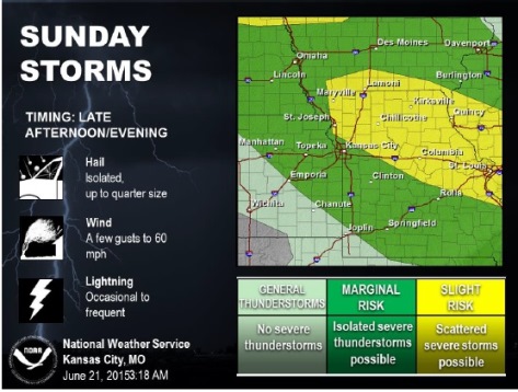
Severe weather will be possible late this afternoon into this evening along a stalled frontal boundary, the weather service said.
Wyandotte County has a 30 percent chance of showers and thunderstorms, mainly before 1 p.m., the weather service said. There is another chance of storms tonight.
Today’s high will be near 92 with the heat index as high as 99, the weather service said.
The best chance for severe weather will be along and north of a Sedalia, Mo., to St. Joseph, Mo., line although isolated severe storms will be possible south of that line, according to the weather service.
The main threat with thunderstorms will be large hail and damaging winds, the weather service said. Storms will begin to weaken and diminish after sunset.
Tonight, there is a 20 percent chance of showers and thunderstorms before 10 p.m. The low will be around 75.
Monday, it will be sunny with a high near 90, and a heat index possibly as high as 104, according to the weather service. The south southwest wind will be 15 to 22 mph Monday with gusts as high as 31 mph.
Hot and humid conditions will return on Monday with highs in the low to mid 90s and heat index values between 100 to 105 degrees, the weather service said.