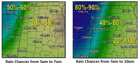
Thunderstorms could move into the area later this evening, according to the National Weather Service.
Strong to severe storms will be possible with gusty winds, frequent lightning and heavy rain being the primary concerns as these storms move southeast, the weather service said.
More showers and thunderstorms will be possible mid-week, according to the weather service. Severe weather is not anticipated with this activity.
Today, there is a 30 percent chance of showers and thunderstorms in Wyandotte County, mainly after 4 p.m., the weather service said. It will be partly sunny with a high near 89, and a south wind of 6 to 9 mph.
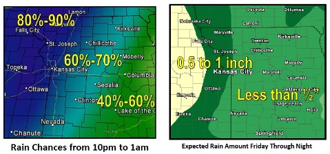
Tonight, the chance of showers and storms is 90 percent, according to the weather service. The low is around 67 and a south wind of 8 to 10 mph will become west after midnight. Between a half and three-quarters of an inch is possible.
On Saturday, there is a 60 percent chance of showers and thunderstorms likely, mainly before 7 a.m., the weather service said. The high will be near 76 with a north northwest wind of 10 to 14 mph, gusting as high as 20 mph.
Saturday night, it will be mostly clear with a low of 56, according to the weather service. A north northwest wind of 5 to 10 mph will become light after midnight.
On Sunday, expect sunny skies with a high near 80, the weather service said. A northwest wind will be around 6 mph.
Sunday night, the low will be about 60 with mostly clear skies, according to the weather service.