Isolated to scattered storms are possible today through the end of the weekend, according to the National Weather Service, and the heat index today could reach the lower to middle 90s.
The best chance for more widespread rain will be on Saturday, the weather service said.
Severe weather is not expected with these storms, but localized wind gusts up to 50 mph and small hail will be possible each day with any storm that develops, according to the weather service.
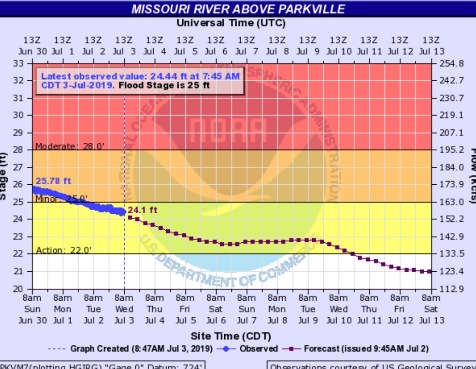
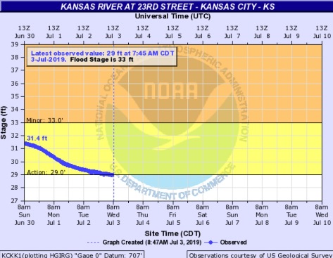
The Missouri River and the Kansas River in the Wyandotte County area are currently below flood stage. The Missouri River at Parkville, which includes Wyandotte County, has dropped below flood stage into the action stage, while the Kansas River at 23rd Street, where the gauge is at Kansas Avenue and the state line, almost has dropped below action stage.
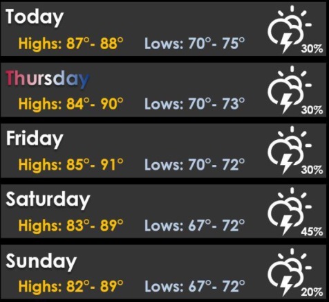
Today, there is a 30 percent chance of showers and thunderstorms, mainly after 3 p.m., the weather service said. The high will be near 88 with a south wind of 3 to 6 mph. Between a tenth and quarter-inch of rain is possible.
Tonight, there is a 30 percent chance of showers and thunderstorms, mainly between 1 a.m. and 4 a.m., with a low of 74, according to the weather service. A south wind of 5 mph will become calm in the evening. Less than a tenth of an inch of rain is possible.
On Thursday, Independence Day, there is a 30 percent chance of showers and thunderstorms, mainly after 1 p.m., with a high near 88 and a south wind of 3 to 6 mph, the weather service said. Less than a tenth of an inch of rain is expected. While there is a chance of storms and rain on Thursday and Thursday night, the chances are not high enough at this time to require cancellations of any outdoor events.
Thursday night, there is a 20 percent chance of showers and thunderstorms after 1 a.m., with a low of 72, according to the weather service, and a south wind of 5 mph becoming calm in the evening.
Friday, there is a 20 percent chance of showers and thunderstorms, with a high near 90 and a calm wind, the weather service said.
Friday night, there is a 30 percent chance of showers and thunderstorms, with a low of 72, according to the weather service.
Saturday, there is a 40 percent chance of showers and thunderstorms, with a high near 88, the weather service said.
Saturday night, there is a 30 percent chance of showers, with thunderstorms also possible after 1 a.m., according to the weather service. The low will be around 72.
Sunday, there is a 30 percent chance of showers and thunderstorms before 1 p.m., with a high near 88, the weather service said.
Sunday night, it will be mostly cloudy with a low of 71, according to the weather service.
Monday, it will be partly sunny with a high near 90, the weather service said.
Monday night, it will be partly cloudy, with a low of 73, according to the weather service.