The forecast contains a chance of isolated to scattered storms tonight into Tuesday morning, according to the National Weather Service.
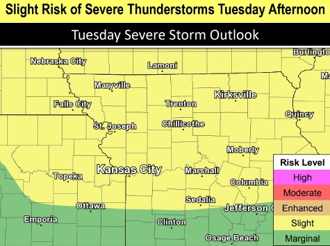
While widespread severe weather is not expected with the initial storms Monday night, storm chances may increase Tuesday afternoon and continue into the weekend, the weather service said.
Some storms may become severe Tuesday afternoon and evening, according to the weather service.
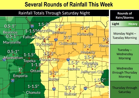
In Wyandotte County, there could be a quarter to half-inch of rain tonight and in the early morning Tuesday, the weather service said. By the end of the week, there could be from 1.5 inches to 2 inches of rain here.
There is rain in the forecast every day through Saturday. To check the hours of the day that are more likely to be dry, visit the hourly weather forecast at https://forecast.weather.gov/MapClick.php?lat=39.1313&lon=-94.6457&unit=0&lg=english&FcstType=graphical.
Flash flooding and general flooding are in the forecast. Moderate river flooding continues in the Kansas City area, on the Missouri River. The flood warning is in effect through June 13. Residents are advised to turn around and not drive through flooded roadways.
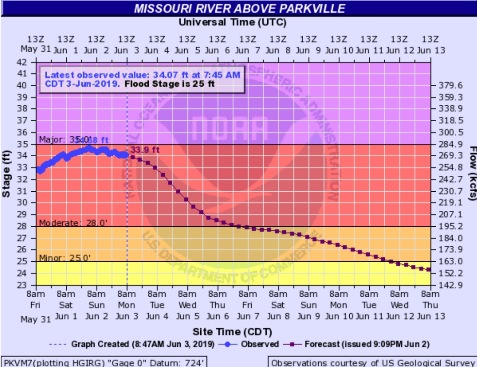
The Missouri River at Parkville, an area that includes Wyandotte County, was at 34.07 feet in moderate flood stage at 7:45 a.m. Monday, according to hydrology reports. Flood stage there is 25 feet. The river at that point reached 34.68 feet over the weekend, and is now declining slightly.
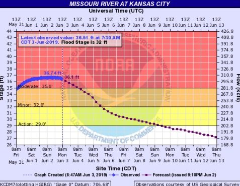
The Missouri River at Kansas City, where the gauge is at U.S. 169 and the Missouri River near the River Market area of Kansas City, Missouri, was at 36.51 feet at 7:30 a.m. Monday, at moderate flood stage, where flood stage begins at 32 feet. It had declined slightly since 36.74 feet over the weekend.
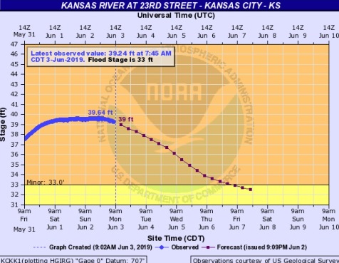
The Kansas River at 23rd Street, where the gauge is at Kansas Avenue and the state line, was at 39.24 feet at 7:45 a.m. Monday, where the flood stage is 33 feet. The river had declined slightly since it was 39.64 feet over the weekend.
Today, there is a 20 percent chance of showers and thunderstorms between 2 p.m. and 4 p.m., the weather service said. The high will be near 82 with a south southeast wind of 7 to 9 mph.
Tonight, there is a 60 percent chance of showers and thunderstorms likely, mainly after 4 a.m., according to the weather service. The low will be around 68, with a south southeast wind of 9 mph. New rainfall amounts of between a quarter and half-inch of rain is possible.
Tuesday, there is a 60 percent chance of showers and thunderstorms likely, mainly before 7 a.m., the weather service said. The high will be near 86, with a south wind of 9 to 13 mph. Between a quarter and half-inch of rain is possible.
Tuesday night, there is a 30 percent chance of showers and thunderstorms, mainly after 1 a.m., according to the weather service. The low will be around 69 with a south southwest wind of 8 to 11 mph, gusting as high as 18 mph. Less than a tenth of an inch of rain is possible.
Wednesday, expect a 40 percent chance of showers and thunderstorms after 1 p.m., the weather service said. The high will be near 86 with a west southwest wind of 5 to 7 mph. Less than a tenth of an inch of rain is expected.
Wednesday night, there is a 40 percent chance of showers and thunderstorms, with a low of 66, according to the weather service. Between a tenth and quarter-inch of rain is possible.
Thursday, there is a 50 percent chance of showers and thunderstorms, with a high near 80, the weather service said. The high will be near 80.
Thursday night, there is a 50 percent chance of showers and thunderstorms, with a low near 66, according to the weather service.
Friday, there is a 50 percent chance of showers and thunderstorms, with a high near 79, the weather service said.
Friday night, it will be mostly cloudy with a low of 66, according to the weather service.
Saturday, there is a 30 percent chance of showers and thunderstorms, with a high near 82, the weather service said.
Saturday night, it will be mostly cloudy, with a low of 66, according to the weather service.
Sunday, it will be partly sunny, with a high near 87, the weather service said.
For more weather information, visit www.weather.gov.