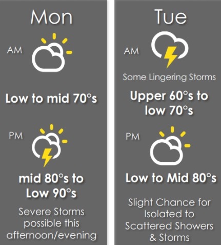
Scattered storms are expected this afternoon through Tuesday morning, according to the National Weather Service.
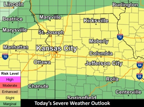
Some strong to severe storms are possible this afternoon and evening, the weather service said.
Damaging winds of 60 mph and frequent lightning are the main hazards. Isolated hail up to 1 inch is also possible, according to the weather service.
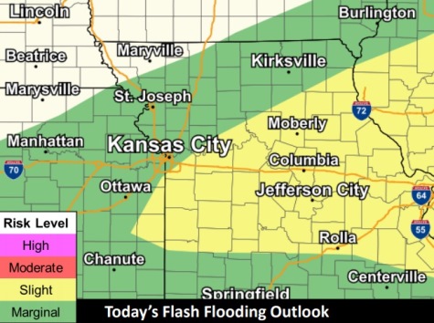
Heavy rain, leading the flash flooding, also is possible, the weather service said.
Multiple rounds of thunderstorms are possible through the work week; however, the potential for severe weather beyond today is low, according to the weather service.
Storms are possible after 1 p.m. today, and may continue until 7 p.m. Tuesday. After a short break, rain may start again around 1 a.m. Wednesday, according to the forecast.
Multiple rounds of thunderstorms are possible throughout the work week however, the potential for severe weather beyond today is low.
Today, there is a 40 percent chance of showers and thunderstorms after 1 p.m., the weather service said. The high will be near 91 with a heat index as high as 98. A south southwest wind will be 7 to 9 mph. Less than a tenth of an inch of rain is possible.
Tonight, there is a 50 percent chance of showers and thunderstorms, with a low around 70, according to the weather service. A light and variable wind will become southeast around 6 mph in the evening. Between a quarter and half-inch of rain is possible.
Tuesday, there is a 20 percent chance of showers and thunderstorms, with a high near 87, the weather service said. A calm wind will become southeast around 6 mph in the afternoon.
Tuesday night, there is a 20 percent chance of showers and thunderstorms after 1 a.m., according to the weather service. The low will be around 70 with a southeast wind around 5 mph becoming calm in the evening.
Wednesday, there is a 30 percent chance of showers and thunderstorms, mainly after 1 p.m., the weather service said. The high will be near 88 with a calm wind becoming south southeast around 6 mph in the morning. Less than a tenth of an inch of rain is expected.
Wednesday night, there is a 30 percent chance of showers and thunderstorms after 1 a.m., with a low of 71, according to the weather service. The low will be around 71. Between a quarter and half-inch of rain is possible.
Thursday, there is a 40 percent chance of showers and thunderstorms, with a high near 88, the weather service said.
Thursday night, there is a 40 percent chance of showers and thunderstorms after 1 a.m., according to the weather service. The low will be around 71.
Friday, there is a 30 percent chance of showers and thunderstorms before 1 p.m., the weather service said. The high will be near 88.
Friday night, it will be partly cloudy with a low of 72, according to the weather service.
Saturday, it will be mostly sunny, with a high near 89, the weather service said.
Saturday night, it will be mostly clear with a low of 70, according to the weather service.
Sunday, it will be mostly sunny, with a high near 85, the weather service said.
For more weather information, visit www.weather.gov.