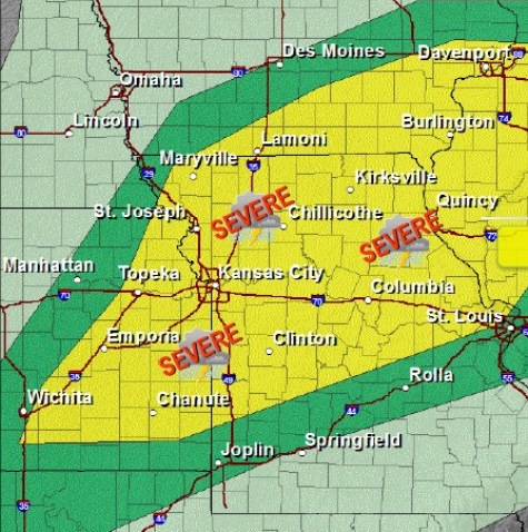
A strong cold front will move through the area this afternoon, triggering strong to severe thunderstorms as it moves from northwest to southeast, according to the National Weather Service.
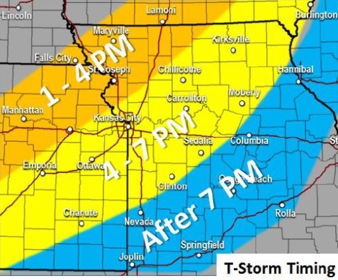
The best timing for any severe storms will be from 1 p.m. to 7 p.m. in the region, as the storm moves from northwest to southeast, the weather service said. In Wyandotte County, according to some weather forecasts, storms may be possible from 3 p.m. through 7 p.m., with storms most likely around 4 p.m. to 5 p.m. today.
To keep up-to-date on latest weather forecasts, visit www.weather.gov or listen to a weather radio station, KID 77 in Kansas City.
Large hail and damaging winds are possible with the strongest storms, according to the weather service.
The primary hazards of the storms include dangerous cloud-to-ground lightning, hail and gusty winds, possibly damaging winds, the weather service said.
The Missouri River at Leavenworth is currently at action stage, which is slightly below flood stage, according to NWS and NOAA hydrology charts. Stranger Creek at Tonganoxie, Kan., also is in the action stage.
In Wyandotte County, the rivers are currently not at flood stage. The Missouri River at Kansas City is currently at 24.07 feet, where flood stage is 32 feet. The Kansas River in Kansas City, Kan., is at 25.53 feet, where flood stage is 33 feet, according to hydrology charts.
The Missouri River at Atchison, Kan., and at St. Joseph, Mo., is experiencing flooding, according to NOAA.
An unsettled pattern will persist late Sunday night into the middle of next week, with multiple rounds of storm chances, the weather service said.
Today’s high will be near 77, the weather service said, with a 90 percent chance of precipitation. Showers and thunderstorms are in the forecast, with a west southwest wind of 7 to 16 mph, gusting to as high as 25 mph. Rainfall amounts may be between a tenth and quarter of an inch, with more rain possible in thunderstorms.
Tonight, there is a 30 percent chance of precipitation, mainly before 7 p.m., when showers and thunderstorms are possible, according to the weather service. The low will be around 43. A north northwest wind of 7 to 14 mph is possible.
Saturday, the forecast is mostly sunny with a high near 60, and a north northwest wind of 8 to 11 mph, the weather service said.
Saturday night, the low will be around 42, with partly cloudy skies, and a north northwest wind of 3 to 8 mph, according to the weather service.
Sunday, the high will be near 63 with mostly sunny skies, according to the weather service. A calm wind will become west southwest around 6 mph in the afternoon.
Sunday night, the low will be around 48 with a 40 percent chance of showers, the weather service said. Between a tenth and a quarter of an inch of rain is possible.
Monday, expect an 80 percent chance of showers with a high of 57, according to the weather service. Monday night, the low will be around 49 with a 70 percent chance of showers, the weather service said.