Scattered thunderstorms are possible today, mainly across northeast Kansas and northwest Missouri, according to the National Weather Service.
A few storms may produce gusty winds and small hail, the weather service said. Wednesday morning, the storms were to the north of the Kansas City area, but more storms were located to the west and moving in this direction in the afternoon.
Today, there is a 50 percent chance of showers and thunderstorms, mainly after noon, according to the weather service. Today’s high will be near 84, with a southeast wind of 6 to 8 mph. Rainfall amounts could be a tenth to a quarter of an inch.
Tonight, a rain and storm chance of 40 percent is in the forecast, with a low of 66 and a southeast wind of 6 mph, the weather service said. New rainfall amounts may be a tenth to a quarter of an inch.
Thursday’s forecast also contains a 40 percent chance of showers and thunderstorms, according to the weather service. The high will be near 84 with a south southeast wind of 6 mph becoming west in the afternoon. Between a tenth and a quarter inch of rain is possible.
Thursday night, expect a 50 percent chance of showers and storms, the weather service said. The low will be around 67 with a west wind of 5 mph becoming light and variable.
Friday, there is a 30 percent chance of showers and thunderstorms, with a high near 83, according to the weather service. The high will be near 83 with an east wind of 5 to 9 mph.
Friday night, there is a 50 percent chance of showers and thunderstorms, according to the weather service.
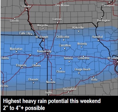
There is a 50 percent chance of precipitation and storms with a high near 77 on Saturday, the weather service said.
On Monday, Independence Day, there is a 30 percent chance of showers and storms with a high near 85, according to the weather service.