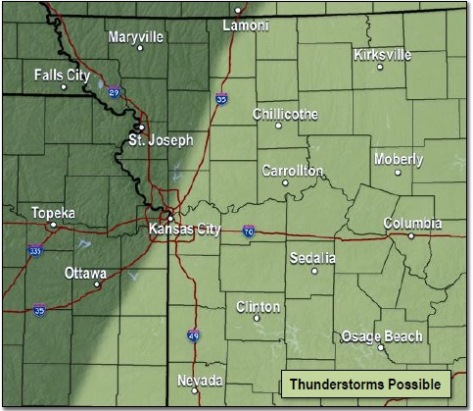
A cold front will move through the area today bringing a chance for showers and a few storms, mainly east of I-35, according to the National Weather Service.
No severe weather is expected with this activity, the weather service said.
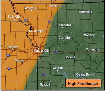
High fire danger is expected behind the front this afternoon as winds increase from the northwest and humidity values drop, according to the weather service.
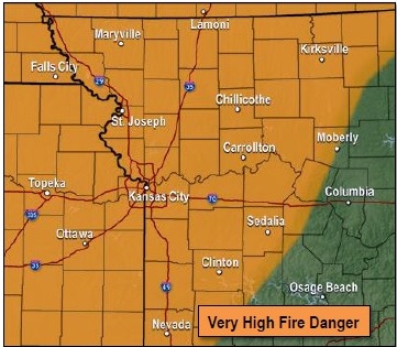
Very high fire danger with strong northwesterly winds is expected Tuesday, the weather service said. Outdoor burning should be postponed as the strong winds could quickly spread any fire, according to forecasters.
The factors leading to high fire danger this afternoon include increasing winds and dropping humidity values behind a cold front, the weather service said.
Very high fire danger on Tuesday afternoon will be caused by strong west to northwest winds and low humidity values, according to the weather service.
Today, patchy showers are possible in Wyandotte County before 2 p.m., then a 30 percent chance of showers and thunderstorms between 2 p.m. and 3 p.m., the weather service said. It will be cloudy through mid-morning, then gradually clearing, with a high of 69. The south wind of 17 to 22 mph will become west northwest in the afternoon. Winds may gust as high as 31 mph today.
Tonight, it will be mostly clear with a low of 29, according to the weather service. A northwest wind of 17 to 22 mph will decrease to 11 to 16 mph after midnight. Winds may gust as high as 31 mph.
Tuesday, it will be sunny with a high near 46, the weather service said. A west wind of 10 to 15 mph will increase to 18 to 23 mph in the afternoon, gusting as high as 38 mph.
Tuesday night, it will be mostly clear with a high of 30, according to the weather service, and a west wind of 6 to 13 mph.
Wednesday, the high will be near 45 with mostly sunny skies, the weather service said. A northwest wind will be 13 to 18 mph, with gusts as high as 28 mph.
Wednesday night, the low will be around 25 with partly cloudy skies, according to the weather service.
Thursday, expect a high near 36 with partly sunny skies, the weather service said.
Thursday night, the low will be around 23 with partly cloudy skies, according to the weather service.
Friday, the high will be near 36 with mostly sunny skies, the weather service said.
Friday night, the low will be around 22 with partly sunny skies, according to the weather service.
Saturday, it will be sunny with a high near 39, the weather service said.
Saturday night, it will be mostly clear with a low of 26, according to the weather service.
Sunday, it will be sunny with a high near 49, the weather service said.