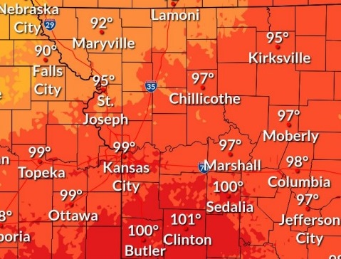
Thunderstorms are possible between 2 p.m. and 4 p.m. Friday, with the heat index reaching nearly 100, according to the National Weather Service forecast.
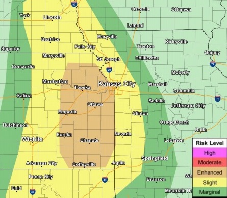
Strong to severe storms are possible, the weather service said. Winds up to 60 mph, lightning and hail up to the size of quarters will be the main threats, according to the weather service. Locally heavy rainfall will be possible.
While Wyandotte County was not under a thunderstorm watch at 9 a.m., areas to the north, including Atchison County, were under a thunderstorm watch, according to the weather service.
Storms may move south into the Kansas City area in the afternoon, clearing out of the forecast area by 7 to 9 p.m., the weather service said.
Also, the maximum heat index today will be approaching 100 degrees, according to the weather service. It was 84 degrees at 9 a.m., and the heat index was 90.
Residents need to use caution if spending time outdoors, the weather service said.
Today, there is a 60 percent chance of showers and thunderstorms, mainly between 2 p.m. and 4 p.m., the weather service said. The high will be near 92 with a heat index as high as 100. A south wind will be 3 to 8 mph. Between a tenth and quarter-inch of rain is in the forecast.
Tonight, there is a 40 percent chance of showers and thunderstorms, mainly before 1 a.m., according to the weather service. It will be mostly cloudy, with a low around 70, and a south southeast wind of 5 to 7 mph becoming northwest in the evening. Less than a tenth of an inch of rain is expected.
Saturday, it will be sunny with a high near 89 and a north wind of 6 to 10 mph, the weather service said.
Saturday night, it will be clear, with a low of 65 and a northeast wind of 6 mph becoming calm in the evening, according to the weather service.
Sunday, it will be sunny, with a high near 91 and a calm wind becoming east around 5 mph, the weather service said.
Sunday night, it will be mostly clear, with a low of 64, according to the weather service.
Monday, it will be sunny, with a high near 94, the weather service said.
Monday night, it will be mostly clear, with a low of 68, according to the weather service.
Tuesday, it will be sunny, with a high near 93, the weather service said.
Tuesday night, it will be mostly clear, with a low of 64, according to the weather service.
Wednesday, it will be sunny, with a high near 91, the weather service said.
Wednesday night, it will be clear, with a low of 64, according to the weather service.
Thursday, it will be sunny, with a high near 93, the weather service said.
For more weather information, visit www.weather.gov.