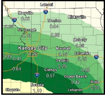
There is 30 percent chance of showers and thunderstorms today, mainly before 2 p.m., according to the National Weather Service. Most of the rain has moved south of Wyandotte County this morning.
It also is the final day of low temperatures this week, as the high will be near 81 today, the weather service said. An east wind of 5 to 9 mph will become calm in the afternoon.
Storms will approach from the south through the morning and early afternoon, according to the weather service. No severe storms are expected, and rain amounts will be less than an inch.
Another round of storms is possible late tonight, the weather service said. Tonight’s storms are mostly likely after 4 a.m., and the overnight low will be 72, according to the weather service.
Heat will begin to build back in Tuesday, the weather service said. By Wednesday and Thursday, a heat index of 105 is possible.
Tuesday’s forecast is a high of 89 with a heat index as high as 98, according to the weather service. There is a 30 percent chance of showers, mainly before 1 p.m.
On Tuesday night, the low will be around 75 with a south southeast wind of 7 mph, according to the weather service.
Wednesday, expect partly sunny skies and a high of 92, the weather service said, with a south southeast wind of 8 to 11 mph.
On Wednesday night, it will be partly cloudy with a low of 76, according to the weather service.
Thursday it will be mostly sunny with a high near 93, the weather service said.
Thursday night there is a 30 percent chance of showers and thunderstorms, with a low of 76, according to the weather service.