After some morning storms, more storms are possible today, according to the National Weather Service.
Southern Johnson County and Miami County are under flash flood warnings currently, but Wyandotte County is not under a flash flood warning.
A second round of thunderstorms may develop early this afternoon, the weather service said.
Many uncertainties remain regarding intensity of afternoon storms, according to the weather service.
Effects from this morning’s storms will greatly influence the intensity of afternoon storms, the weather service said.
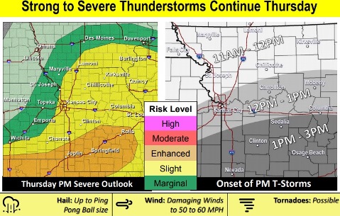
Primary hazards remain gusty winds, heavy rain, and increased flash flooding potential, according to the weather service. Some storms may contain hail. An isolated tornado also cannot be ruled out.
Highest likelihood for severe weather this afternoon is south of I-70, the weather service said. However severe weather is possible throughout the region.
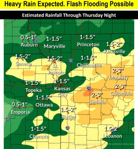
Heavy rainfall from overnight thunderstorms will increase the threat of flash flooding in the region, according to the weather service. More rainfall is expected today, and elevated stream and river levels are possible today.
The Missouri and Kansas rivers were well below flood stage at 9 a.m. Thursday, according to NOAA and USGS hydrology charts. Turkey Creek at Southwest Boulevard rose to 50.47 feet where flood stage is 61 feet at 9:35 a.m. Thursday, still well below flood stage. Action stage there is 55 feet.
Today, there is a 60 percent chance of showers and thunderstorms likely, mainly between noon and 5 p.m., the weather service said. The high will be near 80 with a south wind of 11 to 14 mph, gusting as high as 25 mph. Between a half and three-quarters of an inch of rain is possible.
Tonight, there is a 30 percent chance of showers and thunderstorms before 10 p.m., then a slight chance of showers between 10 p.m. and 11 p.m. The low will be around 48 with a north northwest wind of 9 to 13 mph, gusting as high as 23 mph. Less than a tenth of an inch of rain is possible.
Friday, it will be mostly cloudy, with a high near 63 and a north northwest wind of 10 to 13 mph, the weather service said.
Friday night, it will be partly cloudy, with a low of 46 and a north wind of 5 to 9 mph becoming calm after midnight, according to the weather service.
Saturday, it will be sunny, with a high near 58 and a calm wind becoming east northeast around 6 mph in the morning, the weather service said.
Saturday night, it will be partly cloudy, with a low of 49, according to the weather service.
Sunday, it will be partly sunny, with a high near 70, the weather service said.
Sunday night, there is a 40 percent chance of showers after 1 a.m. The low will be 55.
Monday, Memorial Day, there is a 60 percent chance of showers with a high near 69, the weather service said.
Monday night, there is a 50 percent chance of showers, with a low of 57, according to the weather service.
Tuesday, there is 40 percent chance of showers, with a high near 70, the weather service said.
Tuesday night, there is a 30 percent chance of showers, with a low of 57, according to the weather service.
Wednesday, there is a 40 percent chance of showers, with a high near 72, the weather service said.