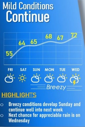
Springlike conditions are continuing through the weekend, with above normal temperatures and dry weather, according to the National Weather Service.
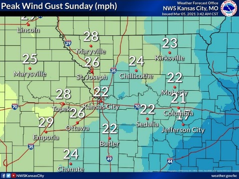
Low relative humidity values and breezy conditions on Sunday will create an elevated fire danger, the weather service said.
The best chance for precipitations will arrive on Wednesday of next week, according to the weather service.
Today, it will be mostly cloudy, then gradually becoming sunny, with a high near 56, and an east wind of 6 to 8 mph, the weather service said.
Tonight, it will be mostly clear, with a low of 36 and an east southeast wind of 5 mph becoming calm in the evening, according to the weather service.
Saturday, it will be sunny, with a high near 64 and a light south southwest wind becoming southwest 5 to 9 mph in the morning, the weather service said.
Saturday night, it will be mostly clear, with a low of 40 and a south wind of 7 mph, according to the weather service.
Sunday, it will mostly sunny, with a high near 65, and a south southwest wind of 8 to 18 mph, gusting as high as 25 mph, the weather service said.
Sunday night, it will be mostly clear, with a low of 46, according to the weather service.
Monday, it will be mostly sunny, with a high near 68, the weather service said.
Monday night, it will be mostly cloudy, with a low of 52, according to the weather service.
Tuesday, it will be partly sunny, with a high near 67, and breezy, the weather service said.
Tuesday night, it will be mostly cloudy, with a low of 58, according to the weather service.
Wednesday, there will be a 30 percent chance of showers with a high near 71, and it will be breezy, the weather service said.
Wednesday night, there is a 40 percent chance of showers, with a low of 47, according to the weather service.
Thursday, there is a 40 percent chance of showers, with a low of 47, the weather service said.