Spring officially started on Sunday. Look for some springtime rain midday and this afternoon, according to the National Weather Service.
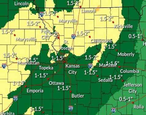
Rain is expected to continue overnight, with up to an inch possible. Then expect more rain and possibly a thunderstorm on Tuesday, the weather service said, with another quarter-inch possible.
Rain doesn’t stop there, as more rain and scattered showers are possible Tuesday night, Wednesday and Wednesday night, according to the weather service forecast.
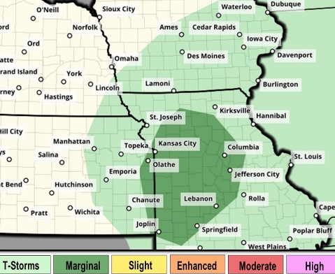
There is the possibility of severe weather Tuesday afternoon with hail, strong winds and a possible tornado, the weather service said. If severe weather occurs, it could be from 1 p.m. to 8 p.m. Tuesday. The forecast is not certain here for the potential tornado activity.
Thursday night, temperatures may go to freezing, as the low is predicted to be 32, according to the weather service.
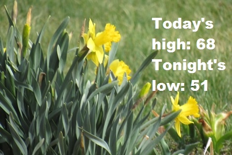
Today, there is a 60 percent chance of rain, mainly after 5 p.m., the weather service said. The high will be near 68 with a south wind of 11 to 16 mph, gusting as high as 30 mph. Between a tenth and quarter-inch of rain is possible.
Tonight, there is a 100 percent chance of rain, with a low of 51, according to the weather service. An east southeast wind of 9 to 11 mph will gust as high as 24 mph. Between three-quarters and one inch of rain is possible.
Tuesday, there is an 80 percent chance of rain and possibly a thunderstorm before 7 a.m., then showers and possibly a thunderstorm, mainly after 7 a.m., the weather service said. The high will be near 59 with a southeast wind of 6 to 14 mph, becoming west northwest in the afternoon. Winds may gust as high as 22 mph. Between a tenth and quarter-inch of rain is possible, except higher amounts are possible in thunderstorms.
Tuesday night, there is a 50 percent chance of rain and thunderstorms, with a low of 36, according to the weather service. A north northwest wind of 15 mph will gust as high as 26 mph. Between a tenth and quarter-inch of rain is possible, except higher amounts are possible in thunderstorms.
Wednesday, there is a 40 percent chance of rain, with a high near 44, the weather service said. A northwest wind of 14 to 17 mph will gust as high as 30 mph. Less than a tenth of an inch of rain is possible.
Wednesday night, there is a 50 percent chance of rain, with a low of 35, according to the weather service. Less than a tenth of an inch of rain is possible.
Thursday, it will be mostly cloudy, with a high near 47, the weather service said.
Thursday night, it will be partly cloudy, with a low of 32, according to the weather service.
Friday, it will be mostly sunny, with a high near 61, the weather service said.
Friday night, it will be mostly clear, with a low of 35, according to the weather service.
Saturday, it will be sunny, with a high near 57, the weather service said.
Saturday night, it will be mostly clear, with a low of 34, according to the weather service.
Sunday, it will be mostly clear, with a low of 34, according to the weather service.