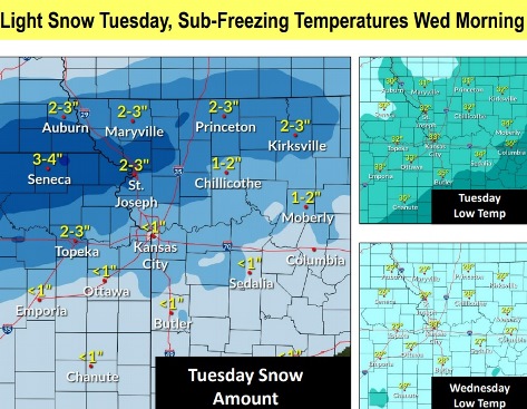
An unusual springtime snow is possible Monday night and Tuesday, according to the National Weather Service.
Temperatures reached a high of 61 on Sunday and are expected to reach a high of 55 on Monday, weather service information showed.
But the low on Monday night could reach 32, according to the weather service.
Snow totals reflect what will accumulate on grassy and elevated surfaces, the weather service said.
Roads will be slushy, and may see some accumulation, so careful travel is suggested, according to the weather service.
Snow will move out from west to east through the day on Tuesday, the weather service said.
A winter weather advisory will be in effect from 10 p.m. Monday, April 19, until 10 a.m. Tuesday, April 20, according to the weather service.
A freeze watch will be in effect from 7 p.m. Tuesday, April 20, through 10 a.m. Wednesday, April 21, the weather service said.
A rain and snow mix is possible after midnight tonight, with snow accumulation of less than one inch, according to the weather service forecast.
Slushy and slippery road conditions will be possible Tuesday, the weather service said. Motorists are asked to slow down and use caution while traveling. The latest road conditions are available by calling 5-1-1 or going to the website, http://www.kandrive.org/kandrive.
For the freeze warning Tuesday night through Wednesday morning, crops and vegetation could be killed in the freeze, and unprotected outdoor plumbing could be damaged, according to the weather service. Residents should take steps now to protect tender plants from the cold.
Outdoor water pipes should be wrapped, drained or allowed to drip slowly. In-ground sprinkler systems should be drained, and above-ground pipes should be covered, the weather service said.
Today, it will be mostly sunny with a high near 55 and a west wind of 7 to 13 mph becoming north in the afternoon, the weather service said.
Tonight, there is a 70 percent chance of rain before midnight, then rain and snow likely, according to the weather service. The low will be 32 with a north wind 11 to 16 mph, gusting as high as 24 mph. Less than 1 inch of snow is possible.
Tuesday, there is a 70 percent chance of rain and snow, becoming all rain after noon, then gradually ending, the weather service said. It will gradually become mostly sunny, with a high near 44. A north wind of 14 mph will gust as high as 18 mph. Less than 1 inch of new snow is possible.
Tuesday night, it will be mostly clear, with a low of 29, according to the weather service. A northwest wind of 5 to 9 mph will become light west after midnight.
Wednesday, it will be mostly sunny, with a high near 51, the weather service said. A light west wind will become northwest 6 to 11 mph in the morning. Winds may gust as high as 22 mph.
Wednesday night, it will be partly cloudy, with a low of 30, according to the weather service.
Thursday, it will be mostly sunny, with a high near 58, the weather service said.
Thursday night, there is a 40 percent chance of rain after 1 a.m., according to the weather service. The low will be around 44.
Friday, there is a 50 percent chance of rain, with a high near 58, the weather service said.
Friday night, there is a 40 percent chance of rain before 1 a.m., with a low of 45, according to the weather service.
Saturday, it will be mostly sunny, with a high near 63, the weather service said.
Saturday night, it will be mostly clear, with a low of 42, according to the weather service.
Sunday, it will be sunny, with a high near 68, the weather service said.